Written and Fact-checked by Whereig Editors, Reviewed by Mukesh Kumar| Updated On: May 15, 2026
Map of McIntosh County - McIntosh County is a county located in the U.S. state of Oklahoma. McIntosh County Map showing cities, highways, important places and water bodies. Get Where is McIntosh County located in the map, major cities in McIntosh county, population, areas, and places of interest.
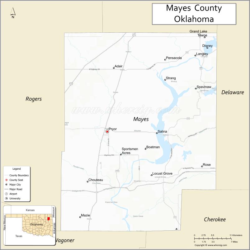
Map of Mayes County, Oklahoma
About McIntosh County Map, Oklahoma: The map showing the county boundary, county seat, major cities, highways, water bodies and neighbouring counties.
Related Oklahoma Maps
About Mayes County, Oklahoma
Mayes County is a county located in the U.S. state of Oklahoma. It's county seat is Pryor. As per 2020 census, the population of Mayes County is 39159 people and population density is 59.69 square miles. According to the United States Census Bureau, the county has a total area of 656 sq mi (1,699 km2). Mayes County was established on 1907.
Mayes County Facts
| Continent | North America |
| Country | United States |
| State | Oklahoma |
| County Seat | Pryor Creek |
| Largest City/Town | Pryor Creek |
| Established | 1907 |
| Total Area | 684 sq mi (1,772 sq km) |
| Land Area | 655 sq mi (1,696 sq km) |
| Water Area | 29 sq mi (75 sq km) |
| Population | 41,259 (Census 2020) |
| Population Density | 63.0 people per sq mi |
| Time Zone | Central Time Zone (CST/CDT) |
| Major Highways | U.S. Route 69, U.S. Route 412, State Highway 20 |
| Major Rivers | Grand River, Arkansas River nearby region, Verdigris River nearby region |
| Neighboring Counties | Craig County, Delaware County, Cherokee County, Wagoner County, Rogers County |
| Famous For | Grand Lake O' the Cherokees nearby region, Pryor industrial development, and eastern Oklahoma recreation |
| Top Attractions | Grand Lake nearby region, MidAmerica Industrial Park, Pryor Creek attractions, and outdoor recreation areas |
| Official Website | Official Website |
About Mayes County, Oklahoma
Mayes County is located in northeastern Oklahoma and was established in 1907 from former Cherokee Nation territory. The county seat and largest city is Pryor Creek. The county is known for industrial development, lake recreation, Cherokee heritage, and scenic eastern Oklahoma landscapes.
Cities and Towns in Mayes County, Oklahoma
| City/Town | Population (Census 2020) | Latitude & Longitude |
|---|---|---|
| Pryor Creek (county seat) | 9,539 | 36.3084°N, 95.3169°W |
| Chouteau | 2,137 | 36.1856°N, 95.3433°W |
| Salina | 1,345 | 36.2770°N, 95.1527°W |
| Locust Grove | 1,437 | 36.2020°N, 95.1689°W |
| Adair | 1,007 | 36.4362°N, 95.2711°W |
| Disney nearby region | 311 | 36.4768°N, 95.0211°W |
Golf Courses in Mayes County, Oklahoma
| Golf Course | Location | Latitude & Longitude |
|---|---|---|
| Pryor Creek Golf Club | Pryor Creek | 36.3204°N, 95.3328°W |
| Patricia Island Country Club nearby region | Grand Lake nearby region | 36.4982°N, 94.9797°W |
| Salina Community Golf Area | Salina nearby region | 36.2869°N, 95.1628°W |
Major Roads and Highways in Mayes County, Oklahoma
Major highways connect Mayes County with Tulsa, northeastern Oklahoma, and regional recreation areas.
- U.S. Route 69 - major north-south transportation corridor through eastern Oklahoma
- U.S. Route 412 - important east-west highway connecting Oklahoma and Arkansas
- State Highway 20 - regional route serving lake and rural communities
What are the Neighboring Counties of Mayes County
- Craig County (north)
- Delaware County (east)
- Cherokee County (south)
- Wagoner County (southwest)
- Rogers County (west)
What are the Top Places to Visit in Mayes County, Oklahoma
The county offers lakes, parks, industrial attractions, and outdoor recreation opportunities.
- Grand Lake O' the Cherokees nearby region - boating, fishing, marinas, and lakeside recreation
- MidAmerica Industrial Park - one of the largest industrial parks in the United States
- Historic Downtown Pryor Creek - local shops, restaurants, and entertainment venues
- Disney Rock Crawling Area nearby region - off-road recreation and scenic lake views
- Fishing and Wildlife Areas - outdoor recreation and birdwatching opportunities
- Camping and RV Parks - family vacations and outdoor recreation
- Community Festivals and Rodeos - local traditions and seasonal events
- Scenic Countryside Drives - photography and eastern Oklahoma landscapes
- Cherokee Heritage Sites nearby region - Native American history and culture
- Nature Trails and Recreation Areas - hiking and environmental exploration
What is the Distance from Mayes County to Nearby Cities
The following distances are measured by road (driving).
- Pryor Creek to Tulsa (Tulsa County), Oklahoma - 41 mi (66 km)
- Pryor Creek to Muskogee (Muskogee County), Oklahoma - 48 mi (77 km)
- Pryor Creek to Joplin (Jasper County), Missouri - 73 mi (117 km)
- Pryor Creek to Oklahoma City (Oklahoma County), Oklahoma - 141 mi (227 km)
- Pryor Creek to Chouteau (Mayes County), Oklahoma - 10 mi (16 km)
- Pryor Creek to Salina (Mayes County), Oklahoma - 23 mi (37 km)
- Pryor Creek to Fayetteville (Washington County), Arkansas - 83 mi (134 km)
- Pryor Creek to Fort Smith (Sebastian County), Arkansas - 98 mi (158 km)
- Pryor Creek to Kansas City (Jackson County), Missouri - 236 mi (380 km)
- Pryor Creek to Dallas (Dallas County), Texas - 278 mi (447 km)
- Pryor Creek to Little Rock (Pulaski County), Arkansas - 219 mi (352 km)
- Pryor Creek to Amarillo (Potter County), Texas - 442 mi (711 km)
- Pryor Creek to Denver (Denver County), Colorado - 648 mi (1,043 km)
FAQs about Mayes County
Mayes County is located in northeastern Oklahoma.
Mayes County had a population of 41,259 according to the 2020 United States Census.
Mayes County is known for Grand Lake recreation, industrial development, and Cherokee heritage.
The county is served by U.S. Route 69, U.S. Route 412, and State Highway 20.
Yes, Mayes County includes golf facilities near Pryor Creek and Grand Lake.
References
- QuickFacts - U.S. Census Bureau
- United States Census Bureau
- United States Geological Survey (USGS)
- National Geodetic Survey
- Official Website
- Adair County Map
- Alfalfa County Map
- Atoka County Map
- Beaver County Map
- Beckham County Map
- Blaine County Map
- Bryan County Map
- Caddo County Map
- Canadian County Map
- Carter County Map
- Cherokee County Map
- Choctaw County Map
- Cimarron County Map
- Cleveland County Map
- Coal County Map
- Comanche County Map
- Cotton County Map
- Craig County Map
- Creek County Map
- Custer County Map
- Delaware County Map
- Dewey County Map
- Ellis County Map
- Garfield County Map
- Garvin County Map
- Grady County Map
- Grant County Map
- Greer County Map
- Harmon County Map
- Harper County Map
- Haskell County Map
- Hughes County Map
- Jackson County Map
- Jefferson County Map
- Johnston County Map
- Kay County Map
- Kingfisher County Map
- Kiowa County Map
- Latimer County Map
- Le Flore County Map
- Lincoln County Map
- Logan County Map
- Love County Map
- McClain County Map
- McCurtain County Map
- McIntosh County Map
- Major County Map
- Marshall County Map
- Mayes County Map
- Murray County Map
- Muskogee County Map
- Noble County Map
- Nowata County Map
- Okfuskee County Map
- Oklahoma County Map
- Okmulgee County Map
- Osage County Map
- Ottawa County Map
- Pawnee County Map
- Payne County Map
- Pittsburg County Map
- Pontotoc County Map
- Pottawatomie County Map
- Pushmataha County Map
- Roger Mills County Map
- Rogers County Map
- Seminole County Map
- Sequoyah County Map
- Stephens County Map
- Texas County Map
- Tillman County Map
- Tulsa County Map
- Wagoner County Map
- Washington County Map
- Washita County Map
- Woods County Map
- Woodward County Map
- Alabama Counties
- Alaska boroughs
- Arizona Counties
- Arkansas Counties
- California County Map
- Colorado Counties
- Connecticut Counties
- Delaware Counties
- Florida County Map
- Georgia County Map
- Hawaii Counties
- Idaho Counties
- Illinois Counties
- Indiana Counties
- Iowa Counties
- Kansas Counties
- Kentucky Counties
- Louisiana Counties
- Maine Counties
- Maryland Counties
- Massachusetts Counties
- Michigan County Map
- Minnesota Counties
- Mississippi Counties
- Missouri Counties
- Montana Counties
- Nebraska Counties
- Nevada Counties
- New York Counties
- New Hampshire Counties
- New Jersey Counties
- New Mexico Counties
- North Carolina Counties
- North Dakota Counties
- Ohio County Map
- Oklahoma Counties
- Oregon Counties
- Pennsylvania Counties
- Rhode Island Counties
- South Carolina Counties
- South Dakota Counties
- Map of Tennessee
- Texas County Map
- Utah Counties
- Vermont Counties
- Virginia Counties
- Washington Counties
- West Virginia Counties
- Wisconsin Counties
- Wyoming Counties