Written and Fact-checked by Whereig Editors, Reviewed by Mukesh Kumar| Updated On: May 15, 2026
Map of Texas County - Texas County is a county located in the U.S. state of Oklahoma. Texas County Map showing cities, highways, important places and water bodies. Get Where is Texas County located in the map, major cities in Texas county, population, areas, and places of interest.
Map of Texas County, Oklahoma
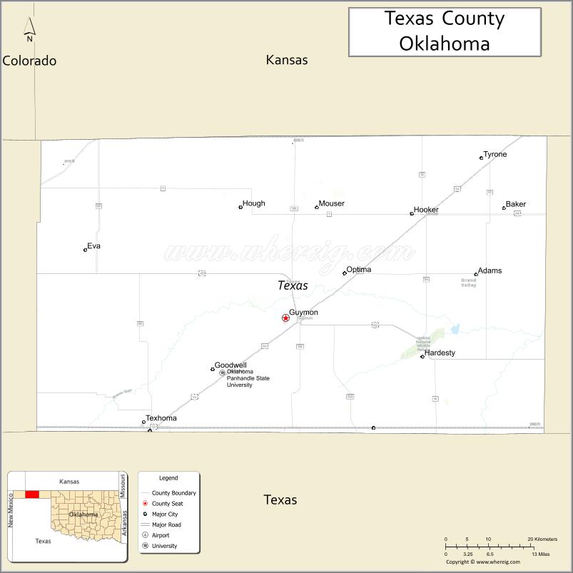
About Texas County Map, Oklahoma: The map showing the county boundary, county seat, major cities, highways, water bodies and neighbouring counties.
Related Oklahoma Maps
About Texas County, Oklahoma
Texas County is a county located in the U.S. state of Oklahoma. It's county seat is Guymon. As per 2020 census, the population of Texas County is 20865 people and population density is 10.24 square miles. According to the United States Census Bureau, the county has a total area of 2,037 sq mi (5,276 km2). Texas County was established on 1907.
Texas County Facts
| Continent | North America |
| Country | United States |
| State | Oklahoma |
| County Seat | Guymon |
| Largest City/Town | Guymon |
| Established | 1907 |
| Total Area | 2,049 sq mi (5,307 sq km) |
| Land Area | 2,041 sq mi (5,286 sq km) |
| Water Area | 8 sq mi (21 sq km) |
| Population | 20,211 (Census 2020) |
| Population Density | 9.9 people per sq mi |
| Time Zone | Central Time Zone (CST/CDT) |
| Major Highways | U.S. Route 54, U.S. Route 64, U.S. Route 412, State Highway 3 |
| Major Rivers | Beaver River, Cimarron River nearby region |
| Neighboring Counties | Cimarron County, Beaver County, Sherman County (Texas), Stevens County (Kansas), Morton County (Kansas) |
| Famous For | High Plains agriculture, cattle feedlots, energy production, and Panhandle culture |
| Top Attractions | No Man's Land Museum, Optima Lake nearby region, and High Plains recreation areas |
| Official Website | Official Website |
About Texas County, Oklahoma
Texas County is located in the Oklahoma Panhandle and is the largest county in Oklahoma by area. Established in 1907, the county seat and largest city is Guymon. The county is known for agriculture, cattle ranching, feedlots, wind energy, and High Plains landscapes.
Cities and Towns in Texas County, Oklahoma
| City/Town | Population (Census 2020) | Latitude & Longitude |
|---|---|---|
| Guymon (county seat) | 12,965 | 36.6828°N, 101.4815°W |
| Hooker | 1,928 | 36.8600°N, 101.2138°W |
| Texhoma | 939 | 36.5092°N, 101.7907°W |
| Tyrone | 762 | 36.9542°N, 101.0699°W |
| Goodwell | 1,293 | 36.5953°N, 101.6299°W |
| Hardesty | 212 | 36.6148°N, 101.1921°W |
Golf Courses in Texas County, Oklahoma
| Golf Course | Location | Latitude & Longitude |
|---|---|---|
| Sunset Hills Golf Course | Guymon | 36.6921°N, 101.4958°W |
| Hooker Community Golf Course | Hooker | 36.8694°N, 101.2252°W |
| Texhoma Recreation Golf Area | Texhoma nearby region | 36.5183°N, 101.8016°W |
Major Roads and Highways in Texas County, Oklahoma
Major highways connect Texas County with the Oklahoma Panhandle, Texas, Kansas, and regional agricultural centers.
- U.S. Route 54 - major transportation corridor through the Oklahoma Panhandle
- U.S. Route 64 - east-west highway serving High Plains communities
- U.S. Route 412 - important route connecting the Panhandle with eastern Oklahoma
- State Highway 3 - regional transportation corridor across northwestern Oklahoma
What are the Neighboring Counties of Texas County
- Morton County, Kansas (north)
- Stevens County, Kansas (northeast)
- Beaver County (east)
- Sherman County, Texas (south)
- Cimarron County (west)
What are the Top Places to Visit in Texas County, Oklahoma
The county offers museums, prairie landscapes, agricultural attractions, and outdoor recreation opportunities.
- No Man's Land Museum - regional history exhibits and Panhandle heritage collections
- Optima Lake nearby region - camping, fishing, boating, and recreation
- Historic Downtown Guymon - local dining, shopping, and cultural attractions
- Oklahoma Panhandle State University in Goodwell - educational and community attractions
- High Plains Scenic Drives - photography and prairie landscapes
- Fishing and Wildlife Areas - birdwatching and environmental exploration
- Community Rodeos and Agricultural Fairs - western traditions and entertainment
- Camping and RV Parks - recreation and travel accommodations
- Wind Energy Landscapes - renewable energy projects across the Panhandle
- Nature Trails and Recreation Areas - hiking and outdoor activities
What is the Distance from Texas County to Nearby Cities
The following distances are measured by road (driving).
- Guymon to Liberal (Seward County), Kansas - 42 mi (68 km)
- Guymon to Amarillo (Potter County), Texas - 118 mi (190 km)
- Guymon to Dodge City (Ford County), Kansas - 145 mi (233 km)
- Guymon to Oklahoma City (Oklahoma County), Oklahoma - 266 mi (428 km)
- Guymon to Hooker (Texas County), Oklahoma - 17 mi (27 km)
- Guymon to Texhoma (Texas County), Oklahoma - 32 mi (51 km)
- Guymon to Wichita (Sedgwick County), Kansas - 248 mi (399 km)
- Guymon to Denver (Denver County), Colorado - 295 mi (475 km)
- Guymon to Albuquerque (Bernalillo County), New Mexico - 326 mi (525 km)
- Guymon to Dallas (Dallas County), Texas - 403 mi (649 km)
- Guymon to Kansas City (Jackson County), Missouri - 489 mi (787 km)
- Guymon to Chicago (Cook County), Illinois - 860 mi (1,384 km)
- Guymon to Los Angeles (Los Angeles County), California - 1,120 mi (1,803 km)
FAQs about Texas County
Texas County is located in the Oklahoma Panhandle.
Texas County had a population of 20,211 according to the 2020 United States Census.
Texas County is known for High Plains agriculture, cattle ranching, feedlots, energy production, and Panhandle culture.
The county is served by U.S. Route 54, U.S. Route 64, U.S. Route 412, and State Highway 3.
Yes, Texas County includes golf facilities such as Sunset Hills Golf Course and Hooker Community Golf Course.
References
- QuickFacts - U.S. Census Bureau
- United States Census Bureau
- United States Geological Survey (USGS)
- National Geodetic Survey
- Official Website
- Adair County Map
- Alfalfa County Map
- Atoka County Map
- Beaver County Map
- Beckham County Map
- Blaine County Map
- Bryan County Map
- Caddo County Map
- Canadian County Map
- Carter County Map
- Cherokee County Map
- Choctaw County Map
- Cimarron County Map
- Cleveland County Map
- Coal County Map
- Comanche County Map
- Cotton County Map
- Craig County Map
- Creek County Map
- Custer County Map
- Delaware County Map
- Dewey County Map
- Ellis County Map
- Garfield County Map
- Garvin County Map
- Grady County Map
- Grant County Map
- Greer County Map
- Harmon County Map
- Harper County Map
- Haskell County Map
- Hughes County Map
- Jackson County Map
- Jefferson County Map
- Johnston County Map
- Kay County Map
- Kingfisher County Map
- Kiowa County Map
- Latimer County Map
- Le Flore County Map
- Lincoln County Map
- Logan County Map
- Love County Map
- McClain County Map
- McCurtain County Map
- McIntosh County Map
- Major County Map
- Marshall County Map
- Mayes County Map
- Murray County Map
- Muskogee County Map
- Noble County Map
- Nowata County Map
- Okfuskee County Map
- Oklahoma County Map
- Okmulgee County Map
- Osage County Map
- Ottawa County Map
- Pawnee County Map
- Payne County Map
- Pittsburg County Map
- Pontotoc County Map
- Pottawatomie County Map
- Pushmataha County Map
- Roger Mills County Map
- Rogers County Map
- Seminole County Map
- Sequoyah County Map
- Stephens County Map
- Texas County Map
- Tillman County Map
- Tulsa County Map
- Wagoner County Map
- Washington County Map
- Washita County Map
- Woods County Map
- Woodward County Map
- Alabama Counties
- Alaska boroughs
- Arizona Counties
- Arkansas Counties
- California County Map
- Colorado Counties
- Connecticut Counties
- Delaware Counties
- Florida County Map
- Georgia County Map
- Hawaii Counties
- Idaho Counties
- Illinois Counties
- Indiana Counties
- Iowa Counties
- Kansas Counties
- Kentucky Counties
- Louisiana Counties
- Maine Counties
- Maryland Counties
- Massachusetts Counties
- Michigan County Map
- Minnesota Counties
- Mississippi Counties
- Missouri Counties
- Montana Counties
- Nebraska Counties
- Nevada Counties
- New York Counties
- New Hampshire Counties
- New Jersey Counties
- New Mexico Counties
- North Carolina Counties
- North Dakota Counties
- Ohio County Map
- Oklahoma Counties
- Oregon Counties
- Pennsylvania Counties
- Rhode Island Counties
- South Carolina Counties
- South Dakota Counties
- Map of Tennessee
- Texas County Map
- Utah Counties
- Vermont Counties
- Virginia Counties
- Washington Counties
- West Virginia Counties
- Wisconsin Counties
- Wyoming Counties