Written and Fact-checked by Whereig Editors, Reviewed by Mukesh Kumar| Updated On: May 15, 2026
Map of Pottawatomie County - Pottawatomie County is a county located in the U.S. state of Oklahoma. Pottawatomie County Map showing cities, highways, important places and water bodies. Get Where is Pottawatomie County located in the map, major cities in Pottawatomie county, population, areas, and places of interest.
Map of Pottawatomie County, Oklahoma
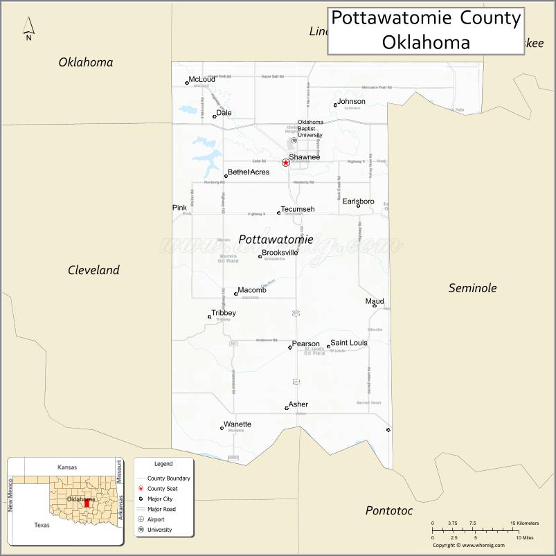
About Pottawatomie County Map, Oklahoma: The map showing the county boundary, county seat, major cities, highways, water bodies and neighbouring counties.
Related Oklahoma Maps
About Pottawatomie County, Oklahoma
Pottawatomie County is a county located in the U.S. state of Oklahoma. It's county seat is Shawnee. As per 2020 census, the population of Pottawatomie County is 73019 people and population density is 92.66 square miles. According to the United States Census Bureau, the county has a total area of 788 sq mi (2,041 km2). Pottawatomie County was established on 1891.
Pottawatomie County Facts
| Continent | North America |
| Country | United States |
| State | Oklahoma |
| County Seat | Shawnee |
| Largest City/Town | Shawnee |
| Established | 1891 |
| Total Area | 793 sq mi (2,054 sq km) |
| Land Area | 788 sq mi (2,041 sq km) |
| Water Area | 5 sq mi (13 sq km) |
| Population | 72,454 (Census 2020) |
| Population Density | 91.9 people per sq mi |
| Time Zone | Central Time Zone (CST/CDT) |
| Major Highways | Interstate 40, U.S. Route 177, State Highway 18, Kickapoo Turnpike nearby region |
| Major Rivers | North Canadian River, Little River |
| Neighboring Counties | Lincoln County, Seminole County, Oklahoma County, Cleveland County, Pontotoc County |
| Famous For | Shawnee heritage, Route 66 history, universities, and central Oklahoma culture |
| Top Attractions | Mabee-Gerrer Museum, Shawnee downtown district, FireLake attractions, and recreation parks |
| Official Website | Official Website |
About Pottawatomie County, Oklahoma
Pottawatomie County is located in central Oklahoma and was established during the Land Run era in 1891. The county seat and largest city is Shawnee. The county is known for Native American heritage, education, Route 66 history, agriculture, and growing suburban communities.
Cities and Towns in Pottawatomie County, Oklahoma
| City/Town | Population (Census 2020) | Latitude & Longitude |
|---|---|---|
| Shawnee (county seat) | 31,040 | 35.3273°N, 96.9253°W |
| Tecumseh | 6,898 | 35.2570°N, 96.9364°W |
| McLoud | 4,137 | 35.4356°N, 97.0911°W |
| Bethel Acres | 2,944 | 35.3609°N, 97.0258°W |
| Asher | 393 | 35.0090°N, 96.9258°W |
| Earlsboro | 599 | 35.2734°N, 96.8050°W |
Golf Courses in Pottawatomie County, Oklahoma
| Golf Course | Location | Latitude & Longitude |
|---|---|---|
| Shawnee Country Club | Shawnee | 35.3497°N, 96.9348°W |
| FireLake Golf Course | Shawnee nearby region | 35.3906°N, 96.9092°W |
| Tecumseh Golf and Recreation Area | Tecumseh | 35.2678°N, 96.9475°W |
Major Roads and Highways in Pottawatomie County, Oklahoma
Major highways connect Pottawatomie County with Oklahoma City, eastern Oklahoma, and regional communities.
- Interstate 40 - major east-west interstate through central Oklahoma
- U.S. Route 177 - important north-south transportation route
- State Highway 18 - regional route serving rural communities
- Kickapoo Turnpike nearby region - modern toll road connecting suburban Oklahoma City areas
What are the Neighboring Counties of Pottawatomie County
- Lincoln County (north)
- Seminole County (east)
- Pontotoc County (south)
- Cleveland County (west)
- Oklahoma County (northwest)
What are the Top Places to Visit in Pottawatomie County, Oklahoma
The county offers museums, parks, Native American cultural attractions, and recreational destinations.
- Mabee-Gerrer Museum of Art - art collections and historical exhibits in Shawnee
- Historic Downtown Shawnee - Route 66 history, restaurants, and shopping
- FireLake Entertainment and Casino nearby region - gaming, concerts, and dining
- Shawnee Twin Lakes - boating, fishing, camping, and outdoor recreation
- Oklahoma Baptist University - historic campus and educational attractions
- Heart of Oklahoma Exposition Center - rodeos, fairs, and community events
- Fishing and Wildlife Areas - birdwatching and outdoor exploration
- Community Festivals and Route 66 Events - seasonal entertainment and local traditions
- Scenic Countryside Drives - photography and central Oklahoma landscapes
- Nature Trails and Recreation Areas - hiking and environmental activities
What is the Distance from Pottawatomie County to Nearby Cities
The following distances are measured by road (driving).
- Shawnee to Oklahoma City (Oklahoma County), Oklahoma - 42 mi (68 km)
- Shawnee to Norman (Cleveland County), Oklahoma - 37 mi (60 km)
- Shawnee to Stillwater (Payne County), Oklahoma - 84 mi (135 km)
- Shawnee to Tulsa (Tulsa County), Oklahoma - 96 mi (154 km)
- Shawnee to Tecumseh (Pottawatomie County), Oklahoma - 4 mi (6 km)
- Shawnee to McLoud (Pottawatomie County), Oklahoma - 16 mi (26 km)
- Shawnee to Fort Smith (Sebastian County), Arkansas - 148 mi (238 km)
- Shawnee to Dallas (Dallas County), Texas - 223 mi (359 km)
- Shawnee to Little Rock (Pulaski County), Arkansas - 299 mi (481 km)
- Shawnee to Kansas City (Jackson County), Missouri - 356 mi (573 km)
- Shawnee to Amarillo (Potter County), Texas - 322 mi (518 km)
- Shawnee to Denver (Denver County), Colorado - 650 mi (1,046 km)
- Shawnee to Chicago (Cook County), Illinois - 731 mi (1,176 km)
FAQs about Pottawatomie County
Pottawatomie County is located in central Oklahoma.
Pottawatomie County had a population of 72,454 according to the 2020 United States Census.
Pottawatomie County is known for Shawnee heritage, Route 66 history, education, and Native American cultural attractions.
The county is served by Interstate 40, U.S. Route 177, State Highway 18, and nearby Kickapoo Turnpike.
Yes, Pottawatomie County includes golf facilities such as Shawnee Country Club and FireLake Golf Course.
References
- QuickFacts - U.S. Census Bureau
- United States Census Bureau
- United States Geological Survey (USGS)
- National Geodetic Survey
- Official Website
- Adair County Map
- Alfalfa County Map
- Atoka County Map
- Beaver County Map
- Beckham County Map
- Blaine County Map
- Bryan County Map
- Caddo County Map
- Canadian County Map
- Carter County Map
- Cherokee County Map
- Choctaw County Map
- Cimarron County Map
- Cleveland County Map
- Coal County Map
- Comanche County Map
- Cotton County Map
- Craig County Map
- Creek County Map
- Custer County Map
- Delaware County Map
- Dewey County Map
- Ellis County Map
- Garfield County Map
- Garvin County Map
- Grady County Map
- Grant County Map
- Greer County Map
- Harmon County Map
- Harper County Map
- Haskell County Map
- Hughes County Map
- Jackson County Map
- Jefferson County Map
- Johnston County Map
- Kay County Map
- Kingfisher County Map
- Kiowa County Map
- Latimer County Map
- Le Flore County Map
- Lincoln County Map
- Logan County Map
- Love County Map
- McClain County Map
- McCurtain County Map
- McIntosh County Map
- Major County Map
- Marshall County Map
- Mayes County Map
- Murray County Map
- Muskogee County Map
- Noble County Map
- Nowata County Map
- Okfuskee County Map
- Oklahoma County Map
- Okmulgee County Map
- Osage County Map
- Ottawa County Map
- Pawnee County Map
- Payne County Map
- Pittsburg County Map
- Pontotoc County Map
- Pottawatomie County Map
- Pushmataha County Map
- Roger Mills County Map
- Rogers County Map
- Seminole County Map
- Sequoyah County Map
- Stephens County Map
- Texas County Map
- Tillman County Map
- Tulsa County Map
- Wagoner County Map
- Washington County Map
- Washita County Map
- Woods County Map
- Woodward County Map
- Alabama Counties
- Alaska boroughs
- Arizona Counties
- Arkansas Counties
- California County Map
- Colorado Counties
- Connecticut Counties
- Delaware Counties
- Florida County Map
- Georgia County Map
- Hawaii Counties
- Idaho Counties
- Illinois Counties
- Indiana Counties
- Iowa Counties
- Kansas Counties
- Kentucky Counties
- Louisiana Counties
- Maine Counties
- Maryland Counties
- Massachusetts Counties
- Michigan County Map
- Minnesota Counties
- Mississippi Counties
- Missouri Counties
- Montana Counties
- Nebraska Counties
- Nevada Counties
- New York Counties
- New Hampshire Counties
- New Jersey Counties
- New Mexico Counties
- North Carolina Counties
- North Dakota Counties
- Ohio County Map
- Oklahoma Counties
- Oregon Counties
- Pennsylvania Counties
- Rhode Island Counties
- South Carolina Counties
- South Dakota Counties
- Map of Tennessee
- Texas County Map
- Utah Counties
- Vermont Counties
- Virginia Counties
- Washington Counties
- West Virginia Counties
- Wisconsin Counties
- Wyoming Counties