Written and Fact-checked by Whereig Editors, Reviewed by Mukesh Kumar| Updated On: May 15, 2026
Map of Johnston County - Johnston County is a county located in the U.S. state of Oklahoma. Johnston County Map showing cities, highways, important places and water bodies. Get Where is Johnston County located in the map, major cities in Johnston county, population, areas, and places of interest.
Map of Johnston County, Oklahoma
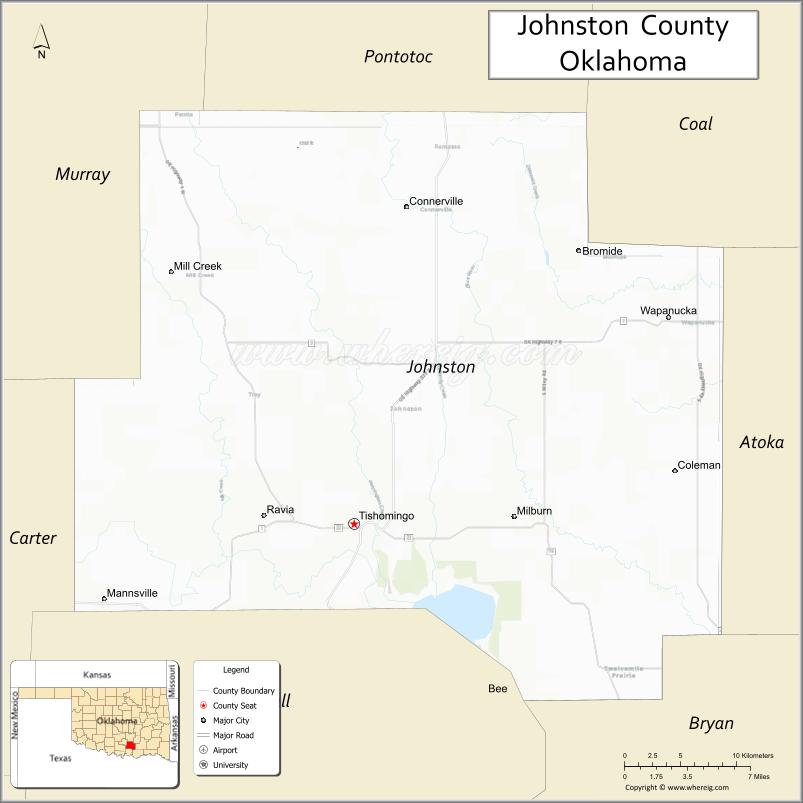
About Johnston County Map, Oklahoma: The map showing the county boundary, county seat, major cities, highways, water bodies and neighbouring counties.
Related Oklahoma Maps
About Johnston County, Oklahoma
Johnston County is a county located in the U.S. state of Oklahoma. It's county seat is Tishomingo. As per 2020 census, the population of Johnston County is 10301 people and population density is 15.97 square miles. According to the United States Census Bureau, the county has a total area of 645 sq mi (1,671 km2). Johnston County was established on 1907.
Johnston County Facts
| Continent | North America |
| Country | United States |
| State | Oklahoma |
| County Seat | Tishomingo |
| Largest City/Town | Tishomingo |
| Established | 1907 |
| Total Area | 658 sq mi (1,704 sq km) |
| Land Area | 643 sq mi (1,665 sq km) |
| Water Area | 15 sq mi (39 sq km) |
| Population | 10,928 (Census 2020) |
| Population Density | 17.0 people per sq mi |
| Time Zone | Central Time Zone (CST/CDT) |
| Major Highways | U.S. Route 377, State Highway 22, State Highway 99 |
| Major Rivers | Blue River, Washita River nearby region, Lake Texoma nearby region |
| Neighboring Counties | Pontotoc County, Coal County, Atoka County, Bryan County, Marshall County, Murray County |
| Famous For | Chickasaw Nation heritage, Blue River fishing, Tishomingo, and southern Oklahoma recreation |
| Top Attractions | Blue River Public Fishing Area, Chickasaw Council House Museum, Pennington Creek Park, and Lake Texoma nearby region |
| Official Website | Official Website |
About Johnston County, Oklahoma
Johnston County is located in south-central Oklahoma and was established in 1907 from former Chickasaw Nation territory. The county seat and largest city is Tishomingo, which once served as the capital of the Chickasaw Nation. The county is known for Native American heritage, outdoor recreation, rivers, and scenic landscapes.
Cities and Towns in Johnston County, Oklahoma
| City/Town | Population (Census 2020) | Latitude & Longitude |
|---|---|---|
| Tishomingo (county seat) | 3,034 | 34.2362°N, 96.6786°W |
| Milburn | 284 | 34.1737°N, 96.5456°W |
| Ravia | 528 | 34.2409°N, 96.7550°W |
| Bromide | 133 | 34.4131°N, 96.5119°W |
| Mannsville nearby region | 804 | 34.1854°N, 96.8793°W |
| Wapanucka nearby area | 379 | 34.3759°N, 96.4202°W |
Golf Courses in Johnston County, Oklahoma
| Golf Course | Location | Latitude & Longitude |
|---|---|---|
| Tishomingo Golf Course | Tishomingo | 34.2471°N, 96.6924°W |
| Blue River Recreation Golf Area | Tishomingo nearby region | 34.2236°N, 96.7012°W |
| Southern Prairie Golf Area | Ravia nearby region | 34.2528°N, 96.7685°W |
Major Roads and Highways in Johnston County, Oklahoma
Major highways connect Johnston County with south-central Oklahoma, Lake Texoma, and neighboring regional communities.
- U.S. Route 377 - major north-south transportation route through southern Oklahoma
- State Highway 22 - important east-west regional corridor
- State Highway 99 - transportation route connecting central and southern Oklahoma
What are the Neighboring Counties of Johnston County
- Coal County (north)
- Pontotoc County (northwest)
- Murray County (west)
- Marshall County (southwest)
- Bryan County (south)
- Atoka County (east)
What are the Top Places to Visit in Johnston County, Oklahoma
The county offers rivers, Native American heritage sites, parks, and outdoor recreation opportunities.
- Blue River Public Fishing Area - trout fishing, hiking, and scenic recreation
- Chickasaw Council House Museum - exhibits on Chickasaw Nation history and culture
- Pennington Creek Park - outdoor recreation and family picnic facilities
- Lake Texoma nearby region - boating, fishing, and lakeside activities
- Historic Downtown Tishomingo - local shops, restaurants, and community attractions
- Fishing and Wildlife Areas - outdoor recreation and birdwatching opportunities
- Scenic Countryside Drives - rolling hills and prairie photography
- Community Festivals and Rodeos - seasonal entertainment and local traditions
- Camping and RV Parks - outdoor recreation and vacation destinations
- Nature Trails and Environmental Exploration - hiking and ecological education
What is the Distance from Johnston County to Nearby Cities
The following distances are measured by road (driving).
- Tishomingo to Ardmore (Carter County), Oklahoma - 42 mi (68 km)
- Tishomingo to Ada (Pontotoc County), Oklahoma - 36 mi (58 km)
- Tishomingo to Durant (Bryan County), Oklahoma - 54 mi (87 km)
- Tishomingo to Oklahoma City (Oklahoma County), Oklahoma - 118 mi (190 km)
- Tishomingo to Milburn (Johnston County), Oklahoma - 10 mi (16 km)
- Tishomingo to Ravia (Johnston County), Oklahoma - 6 mi (10 km)
- Tishomingo to Dallas (Dallas County), Texas - 130 mi (209 km)
- Tishomingo to Tulsa (Tulsa County), Oklahoma - 152 mi (245 km)
- Tishomingo to Wichita Falls (Wichita County), Texas - 132 mi (212 km)
- Tishomingo to Little Rock (Pulaski County), Arkansas - 250 mi (402 km)
- Tishomingo to Kansas City (Jackson County), Missouri - 379 mi (610 km)
- Tishomingo to Amarillo (Potter County), Texas - 350 mi (563 km)
- Tishomingo to Denver (Denver County), Colorado - 699 mi (1,125 km)
FAQs about Johnston County
Johnston County is located in south-central Oklahoma.
Johnston County had a population of 10,928 according to the 2020 United States Census.
Johnston County is known for Chickasaw Nation heritage, Blue River recreation, and scenic southern Oklahoma landscapes.
The county is served by U.S. Route 377, State Highway 22, and State Highway 99.
Yes, Johnston County includes golf and recreation facilities near Tishomingo and the Blue River area.
References
- QuickFacts - U.S. Census Bureau
- United States Census Bureau
- United States Geological Survey (USGS)
- National Geodetic Survey
- Official Website
- Adair County Map
- Alfalfa County Map
- Atoka County Map
- Beaver County Map
- Beckham County Map
- Blaine County Map
- Bryan County Map
- Caddo County Map
- Canadian County Map
- Carter County Map
- Cherokee County Map
- Choctaw County Map
- Cimarron County Map
- Cleveland County Map
- Coal County Map
- Comanche County Map
- Cotton County Map
- Craig County Map
- Creek County Map
- Custer County Map
- Delaware County Map
- Dewey County Map
- Ellis County Map
- Garfield County Map
- Garvin County Map
- Grady County Map
- Grant County Map
- Greer County Map
- Harmon County Map
- Harper County Map
- Haskell County Map
- Hughes County Map
- Jackson County Map
- Jefferson County Map
- Johnston County Map
- Kay County Map
- Kingfisher County Map
- Kiowa County Map
- Latimer County Map
- Le Flore County Map
- Lincoln County Map
- Logan County Map
- Love County Map
- McClain County Map
- McCurtain County Map
- McIntosh County Map
- Major County Map
- Marshall County Map
- Mayes County Map
- Murray County Map
- Muskogee County Map
- Noble County Map
- Nowata County Map
- Okfuskee County Map
- Oklahoma County Map
- Okmulgee County Map
- Osage County Map
- Ottawa County Map
- Pawnee County Map
- Payne County Map
- Pittsburg County Map
- Pontotoc County Map
- Pottawatomie County Map
- Pushmataha County Map
- Roger Mills County Map
- Rogers County Map
- Seminole County Map
- Sequoyah County Map
- Stephens County Map
- Texas County Map
- Tillman County Map
- Tulsa County Map
- Wagoner County Map
- Washington County Map
- Washita County Map
- Woods County Map
- Woodward County Map
- Alabama Counties
- Alaska boroughs
- Arizona Counties
- Arkansas Counties
- California County Map
- Colorado Counties
- Connecticut Counties
- Delaware Counties
- Florida County Map
- Georgia County Map
- Hawaii Counties
- Idaho Counties
- Illinois Counties
- Indiana Counties
- Iowa Counties
- Kansas Counties
- Kentucky Counties
- Louisiana Counties
- Maine Counties
- Maryland Counties
- Massachusetts Counties
- Michigan County Map
- Minnesota Counties
- Mississippi Counties
- Missouri Counties
- Montana Counties
- Nebraska Counties
- Nevada Counties
- New York Counties
- New Hampshire Counties
- New Jersey Counties
- New Mexico Counties
- North Carolina Counties
- North Dakota Counties
- Ohio County Map
- Oklahoma Counties
- Oregon Counties
- Pennsylvania Counties
- Rhode Island Counties
- South Carolina Counties
- South Dakota Counties
- Map of Tennessee
- Texas County Map
- Utah Counties
- Vermont Counties
- Virginia Counties
- Washington Counties
- West Virginia Counties
- Wisconsin Counties
- Wyoming Counties