Written and Fact-checked by Whereig Editors, Reviewed by Mukesh Kumar| Updated On: May 15, 2026
Map of Tillman County - Tillman County is a county located in the U.S. state of Oklahoma. Tillman County Map showing cities, highways, important places and water bodies. Get Where is Tillman County located in the map, major cities in Tillman county, population, areas, and places of interest.
Map of Tillman County, Oklahoma
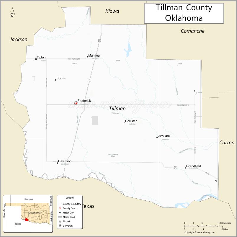
About Tillman County Map, Oklahoma: The map showing the county boundary, county seat, major cities, highways, water bodies and neighbouring counties.
Related Oklahoma Maps
About Tillman County, Oklahoma
Tillman County is a county located in the U.S. state of Oklahoma. It's county seat is Frederick. As per 2020 census, the population of Tillman County is 7076 people and population density is 8.11 square miles. According to the United States Census Bureau, the county has a total area of 872 sq mi (2,258 km2). Tillman County was established on 1907.
Tillman County Facts
| Continent | North America |
| Country | United States |
| State | Oklahoma |
| County Seat | Frederick |
| Largest City/Town | Frederick |
| Established | 1907 |
| Total Area | 879 sq mi (2,277 sq km) |
| Land Area | 871 sq mi (2,256 sq km) |
| Water Area | 8 sq mi (21 sq km) |
| Population | 6,968 (Census 2020) |
| Population Density | 8.0 people per sq mi |
| Time Zone | Central Time Zone |
| Major Highways | U.S. Highway 70, U.S. Highway 183, State Highway 5, State Highway 36 |
| Major Rivers | Red River, North Fork Red River |
| Neighboring Counties | Kiowa County, Comanche County, Cotton County, Jackson County, Wichita County (Texas), Wilbarger County (Texas) |
| Famous For | Agriculture, cotton farming, Red River border region, and historic Frederick Army Airfield |
| Top Attractions | Hackberry Flat Wildlife Management Area, Tillman County Courthouse, Pioneer Townsite Museum, Frederick Lake, and Red River recreation areas |
| Official Website | Official Website |
About Tillman County, Oklahoma
Tillman County is located in the southwestern part of Oklahoma along the Texas border and was established in 1907. The county seat is Frederick, which is also the largest city in the county. The area is known for its flat prairie landscape, farming communities, and Red River scenery that forms the southern boundary of the county.
Cities and Towns in Tillman County, Oklahoma
| City/Town | Population (Census 2020) | Latitude & Longitude |
|---|---|---|
| Frederick (county seat) | 3,468 | 34.3920°N, 99.0187°W |
| Grandfield | 936 | 34.2312°N, 98.6845°W |
| Tipton | 847 | 34.5029°N, 99.1403°W |
| Davidson | 242 | 34.2423°N, 99.0728°W |
| Manitou | 150 | 34.5081°N, 98.9809°W |
| Hollister | 48 | 34.3342°N, 99.4339°W |
Golf Courses in Tillman County, Oklahoma
| Golf Course | Location | Latitude & Longitude |
|---|---|---|
| Frederick Golf Club | Frederick | 34.3974°N, 99.0089°W |
| Grandfield Golf and Country Club | Grandfield | 34.2378°N, 98.6925°W |
Major Roads and Highways in Tillman County, Oklahoma
Major highways connect the county to nearby regions and cities.
- U.S. Highway 70 - east-west route connecting Frederick with Ardmore and western Oklahoma
- U.S. Highway 183 - north-south route linking Frederick with Snyder and Vernon, Texas
- State Highway 5 - connects Tipton with Frederick and neighboring Jackson County
- State Highway 36 - serves rural communities in western Tillman County
What are the Neighboring Counties of Tillman County
- Kiowa County (north)
- Comanche County (northeast)
- Cotton County (east)
- Wichita County, Texas (south)
- Wilbarger County, Texas (southwest)
- Jackson County (northwest)
What are the Top Places to Visit in Tillman County, Oklahoma
The county offers a mix of natural and cultural attractions.
- Hackberry Flat Wildlife Management Area - large wetland and birdwatching area known for migrating waterfowl
- Tillman County Courthouse - historic courthouse building located in downtown Frederick
- Pioneer Townsite Museum - local history museum featuring pioneer and military exhibits
- Frederick Lake - popular spot for fishing, boating, and camping
- Frederick Army Airfield Historic Area - former World War II military training airfield
- Red River Access Areas - scenic recreation and fishing locations along the Oklahoma-Texas border
- Tipton City Park - community park with picnic and sports facilities
- Grandfield Community Park - local recreation area with playgrounds and open space
- Tom Steed Reservoir - nearby lake area popular for outdoor recreation
- Main Street Frederick - historic downtown district with local shops and murals
What is the Distance from Tillman County to Nearby Cities
The following distances are measured by road (driving).
- Frederick to Lawton (Comanche County), Oklahoma - 48 mi (77 km)
- Frederick to Altus (Jackson County), Oklahoma - 33 mi (53 km)
- Frederick to Wichita Falls (Wichita County), Texas - 61 mi (98 km)
- Frederick to Vernon (Wilbarger County), Texas - 32 mi (51 km)
- Frederick to Duncan (Stephens County), Oklahoma - 74 mi (119 km)
- Frederick to Ardmore (Carter County), Oklahoma - 121 mi (195 km)
- Frederick to Oklahoma City (Oklahoma County), Oklahoma - 165 mi (266 km)
- Frederick to Amarillo (Potter County), Texas - 218 mi (351 km)
- Frederick to Tulsa (Tulsa County), Oklahoma - 255 mi (410 km)
- Frederick to Clinton (Custer County), Oklahoma - 118 mi (190 km)
- Frederick to Mangum (Greer County), Oklahoma - 62 mi (100 km)
- Frederick to Chickasha (Grady County), Oklahoma - 108 mi (174 km)
FAQs about Tillman County
Tillman County is located in southwestern Oklahoma along the Texas border.
The population of Tillman County was 6,968 according to the Census 2020.
Tillman County is known for agriculture, cotton farming, wildlife areas, and its historic military aviation history.
The main highways include U.S. Highway 70, U.S. Highway 183, State Highway 5, and State Highway 36.
Yes, Tillman County has golf facilities including Frederick Golf Club and Grandfield Golf and Country Club.
References
- QuickFacts - U.S. Census Bureau
- United States Census Bureau
- United States Geological Survey (USGS)
- National Geodetic Survey
- Official County Website
- Adair County Map
- Alfalfa County Map
- Atoka County Map
- Beaver County Map
- Beckham County Map
- Blaine County Map
- Bryan County Map
- Caddo County Map
- Canadian County Map
- Carter County Map
- Cherokee County Map
- Choctaw County Map
- Cimarron County Map
- Cleveland County Map
- Coal County Map
- Comanche County Map
- Cotton County Map
- Craig County Map
- Creek County Map
- Custer County Map
- Delaware County Map
- Dewey County Map
- Ellis County Map
- Garfield County Map
- Garvin County Map
- Grady County Map
- Grant County Map
- Greer County Map
- Harmon County Map
- Harper County Map
- Haskell County Map
- Hughes County Map
- Jackson County Map
- Jefferson County Map
- Johnston County Map
- Kay County Map
- Kingfisher County Map
- Kiowa County Map
- Latimer County Map
- Le Flore County Map
- Lincoln County Map
- Logan County Map
- Love County Map
- McClain County Map
- McCurtain County Map
- McIntosh County Map
- Major County Map
- Marshall County Map
- Mayes County Map
- Murray County Map
- Muskogee County Map
- Noble County Map
- Nowata County Map
- Okfuskee County Map
- Oklahoma County Map
- Okmulgee County Map
- Osage County Map
- Ottawa County Map
- Pawnee County Map
- Payne County Map
- Pittsburg County Map
- Pontotoc County Map
- Pottawatomie County Map
- Pushmataha County Map
- Roger Mills County Map
- Rogers County Map
- Seminole County Map
- Sequoyah County Map
- Stephens County Map
- Texas County Map
- Tillman County Map
- Tulsa County Map
- Wagoner County Map
- Washington County Map
- Washita County Map
- Woods County Map
- Woodward County Map
- Alabama Counties
- Alaska boroughs
- Arizona Counties
- Arkansas Counties
- California County Map
- Colorado Counties
- Connecticut Counties
- Delaware Counties
- Florida County Map
- Georgia County Map
- Hawaii Counties
- Idaho Counties
- Illinois Counties
- Indiana Counties
- Iowa Counties
- Kansas Counties
- Kentucky Counties
- Louisiana Counties
- Maine Counties
- Maryland Counties
- Massachusetts Counties
- Michigan County Map
- Minnesota Counties
- Mississippi Counties
- Missouri Counties
- Montana Counties
- Nebraska Counties
- Nevada Counties
- New York Counties
- New Hampshire Counties
- New Jersey Counties
- New Mexico Counties
- North Carolina Counties
- North Dakota Counties
- Ohio County Map
- Oklahoma Counties
- Oregon Counties
- Pennsylvania Counties
- Rhode Island Counties
- South Carolina Counties
- South Dakota Counties
- Map of Tennessee
- Texas County Map
- Utah Counties
- Vermont Counties
- Virginia Counties
- Washington Counties
- West Virginia Counties
- Wisconsin Counties
- Wyoming Counties