Written and Fact-checked by Whereig Editors, Reviewed by Mukesh Kumar| Updated On: May 15, 2026
Map of Blaine County - Blaine County is a county located in the U.S. state of Oklahoma. Blaine County Map showing cities, highways, important places and water bodies. Get Where is Blaine County located in the map, major cities in Blaine county, population, areas, and places of interest.
Map of Blaine County, Oklahoma
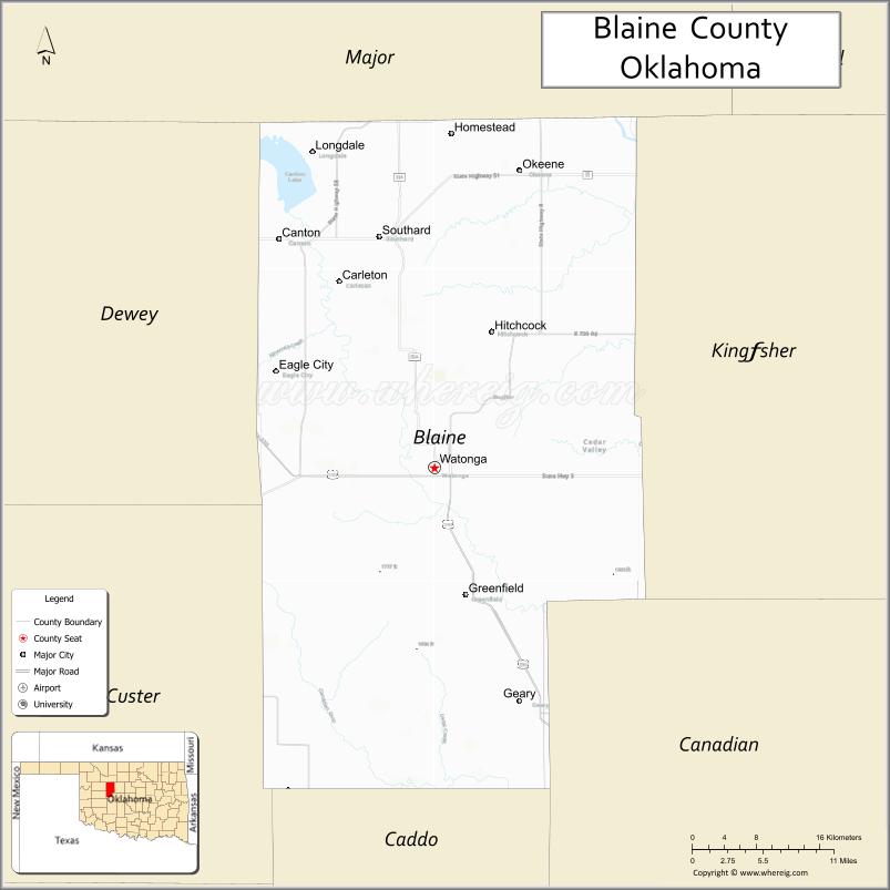
About Blaine County Map, Oklahoma: The map showing the county boundary, county seat, major cities, highways, water bodies and neighbouring counties.
Related Oklahoma Maps
About Blaine County, Oklahoma
Blaine County is a county located in the U.S. state of Oklahoma. It's county seat is Watonga. As per 2020 census, the population of Blaine County is 8562 people and population density is 9.22 square miles. According to the United States Census Bureau, the county has a total area of 929 sq mi (2,406 km2). Blaine County was established on 1890.
Blaine County Facts
| Continent | North America |
| Country | United States |
| State | Oklahoma |
| County Seat | Watonga |
| Largest City/Town | Watonga |
| Established | 1892 |
| Total Area | 939 sq mi (2,432 sq km) |
| Land Area | 928 sq mi (2,404 sq km) |
| Water Area | 11 sq mi (28 sq km) |
| Population | 8,418 (Census 2020) |
| Population Density | 9.1 people per sq mi |
| Time Zone | Central Time Zone (CST/CDT) |
| Major Highways | U.S. Route 270, State Highway 3, State Highway 8 |
| Major Rivers | North Canadian River, Canton Lake nearby region |
| Neighboring Counties | Kingfisher County, Canadian County, Custer County, Dewey County, Major County |
| Famous For | Watonga Cheese Festival, prairie landscapes, Native American heritage, and outdoor recreation |
| Top Attractions | Roman Nose State Park, Canton Lake nearby region, Watonga Cheese Festival, and prairie scenic drives |
| Official Website | Official Website |
About Blaine County, Oklahoma
Blaine County is located in west-central Oklahoma and was established during the Land Run era in 1892. The county seat and largest city is Watonga. The county is known for rolling prairie landscapes, Native American history, outdoor recreation, and the annual Watonga Cheese Festival.
Cities and Towns in Blaine County, Oklahoma
| City/Town | Population (Census 2020) | Latitude & Longitude |
|---|---|---|
| Watonga (county seat) | 2,690 | 35.8445°N, 98.4137°W |
| Geary | 1,057 | 35.6317°N, 98.3170°W |
| Okeene | 1,069 | 36.1184°N, 98.3178°W |
| Longdale | 217 | 36.1331°N, 98.5446°W |
| Hitchcock | 102 | 35.9681°N, 98.3482°W |
| Canton nearby region | 381 | 35.8759°N, 98.5889°W |
Golf Courses in Blaine County, Oklahoma
| Golf Course | Location | Latitude & Longitude |
|---|---|---|
| Watonga Golf Club | Watonga | 35.8548°N, 98.4255°W |
| Roman Nose Golf Course | Roman Nose State Park nearby region | 35.9314°N, 98.4342°W |
| Okeene Recreation Golf Area | Okeene | 36.1271°N, 98.3298°W |
Major Roads and Highways in Blaine County, Oklahoma
Major highways connect Blaine County with western Oklahoma, Oklahoma City, and regional recreation areas.
- U.S. Route 270 - major east-west transportation corridor through west-central Oklahoma
- State Highway 3 - important regional route connecting rural communities
- State Highway 8 - north-south highway serving agricultural and recreation regions
What are the Neighboring Counties of Blaine County
- Major County (north)
- Kingfisher County (east)
- Canadian County (southeast)
- Custer County (west)
- Dewey County (northwest)
What are the Top Places to Visit in Blaine County, Oklahoma
The county offers prairie scenery, parks, recreation lakes, and cultural heritage attractions.
- Roman Nose State Park - hiking, camping, golf, lakes, and canyon scenery
- Watonga Cheese Festival - annual celebration featuring food, music, and community events
- Canton Lake nearby region - boating, fishing, swimming, and camping activities
- Prairie Scenic Drives - rolling hills and countryside photography opportunities
- Historic Downtown Watonga - local shops, restaurants, and community heritage
- Native American Heritage Sites - regional cultural history and traditions
- Hunting and Wildlife Areas - deer hunting and birdwatching activities
- Camping and RV Parks - family recreation and outdoor exploration
- Community Festivals and Rodeo Events - local traditions and seasonal entertainment
- Nature Observation Areas - prairie wildlife and environmental education
What is the Distance from Blaine County to Nearby Cities
The following distances are measured by road (driving).
- Watonga to Oklahoma City (Oklahoma County), Oklahoma - 70 mi (113 km)
- Watonga to Enid (Garfield County), Oklahoma - 63 mi (101 km)
- Watonga to Weatherford (Custer County), Oklahoma - 47 mi (76 km)
- Watonga to Clinton (Custer County), Oklahoma - 57 mi (92 km)
- Watonga to Okeene (Blaine County), Oklahoma - 20 mi (32 km)
- Watonga to Geary (Blaine County), Oklahoma - 15 mi (24 km)
- Watonga to Tulsa (Tulsa County), Oklahoma - 155 mi (249 km)
- Watonga to Wichita (Sedgwick County), Kansas - 175 mi (282 km)
- Watonga to Amarillo (Potter County), Texas - 233 mi (375 km)
- Watonga to Dallas (Dallas County), Texas - 304 mi (489 km)
- Watonga to Kansas City (Jackson County), Missouri - 353 mi (568 km)
- Watonga to Denver (Denver County), Colorado - 503 mi (809 km)
- Watonga to Chicago (Cook County), Illinois - 744 mi (1,198 km)
FAQs about Blaine County
Blaine County is located in west-central Oklahoma.
Blaine County had a population of 8,418 according to the 2020 United States Census.
Blaine County is known for Roman Nose State Park, prairie scenery, and the Watonga Cheese Festival.
The county is served by U.S. Route 270, State Highway 3, and State Highway 8.
Yes, Blaine County includes golf facilities such as Roman Nose Golf Course and Watonga Golf Club.
References
- QuickFacts - U.S. Census Bureau
- United States Census Bureau
- United States Geological Survey (USGS)
- National Geodetic Survey
- Official Website
- Adair County Map
- Alfalfa County Map
- Atoka County Map
- Beaver County Map
- Beckham County Map
- Blaine County Map
- Bryan County Map
- Caddo County Map
- Canadian County Map
- Carter County Map
- Cherokee County Map
- Choctaw County Map
- Cimarron County Map
- Cleveland County Map
- Coal County Map
- Comanche County Map
- Cotton County Map
- Craig County Map
- Creek County Map
- Custer County Map
- Delaware County Map
- Dewey County Map
- Ellis County Map
- Garfield County Map
- Garvin County Map
- Grady County Map
- Grant County Map
- Greer County Map
- Harmon County Map
- Harper County Map
- Haskell County Map
- Hughes County Map
- Jackson County Map
- Jefferson County Map
- Johnston County Map
- Kay County Map
- Kingfisher County Map
- Kiowa County Map
- Latimer County Map
- Le Flore County Map
- Lincoln County Map
- Logan County Map
- Love County Map
- McClain County Map
- McCurtain County Map
- McIntosh County Map
- Major County Map
- Marshall County Map
- Mayes County Map
- Murray County Map
- Muskogee County Map
- Noble County Map
- Nowata County Map
- Okfuskee County Map
- Oklahoma County Map
- Okmulgee County Map
- Osage County Map
- Ottawa County Map
- Pawnee County Map
- Payne County Map
- Pittsburg County Map
- Pontotoc County Map
- Pottawatomie County Map
- Pushmataha County Map
- Roger Mills County Map
- Rogers County Map
- Seminole County Map
- Sequoyah County Map
- Stephens County Map
- Texas County Map
- Tillman County Map
- Tulsa County Map
- Wagoner County Map
- Washington County Map
- Washita County Map
- Woods County Map
- Woodward County Map
- Alabama Counties
- Alaska boroughs
- Arizona Counties
- Arkansas Counties
- California County Map
- Colorado Counties
- Connecticut Counties
- Delaware Counties
- Florida County Map
- Georgia County Map
- Hawaii Counties
- Idaho Counties
- Illinois Counties
- Indiana Counties
- Iowa Counties
- Kansas Counties
- Kentucky Counties
- Louisiana Counties
- Maine Counties
- Maryland Counties
- Massachusetts Counties
- Michigan County Map
- Minnesota Counties
- Mississippi Counties
- Missouri Counties
- Montana Counties
- Nebraska Counties
- Nevada Counties
- New York Counties
- New Hampshire Counties
- New Jersey Counties
- New Mexico Counties
- North Carolina Counties
- North Dakota Counties
- Ohio County Map
- Oklahoma Counties
- Oregon Counties
- Pennsylvania Counties
- Rhode Island Counties
- South Carolina Counties
- South Dakota Counties
- Map of Tennessee
- Texas County Map
- Utah Counties
- Vermont Counties
- Virginia Counties
- Washington Counties
- West Virginia Counties
- Wisconsin Counties
- Wyoming Counties