Written and Fact-checked by Whereig Editors, Reviewed by Mukesh Kumar| Updated On: May 15, 2026
Map of Greer County - Greer County is a county located in the U.S. state of Oklahoma. Greer County Map showing cities, highways, important places and water bodies. Get Where is Greer County located in the map, major cities in Greer county, population, areas, and places of interest.
Map of Greer County, Oklahoma
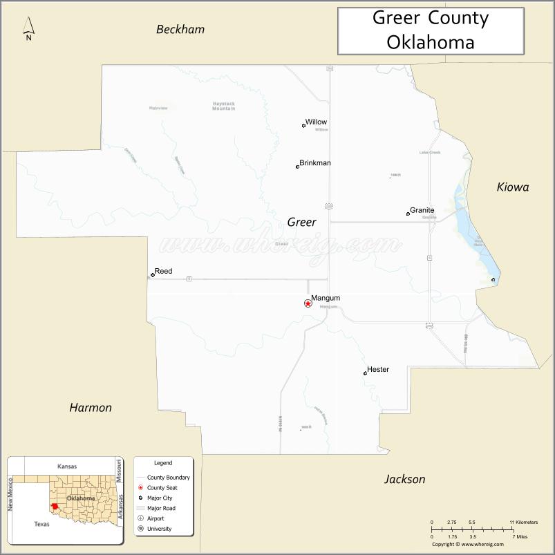
About Greer County Map, Oklahoma: The map showing the county boundary, county seat, major cities, highways, water bodies and neighbouring counties.
Related Oklahoma Maps
About Greer County, Oklahoma
Greer County is a county located in the U.S. state of Oklahoma. It's county seat is Mangum. As per 2020 census, the population of Greer County is 5487 people and population density is 8.59 square miles. According to the United States Census Bureau, the county has a total area of 639 sq mi (1,655 km2). Greer County was established on 1896.
Greer County Facts
| Continent | North America |
| Country | United States |
| State | Oklahoma |
| County Seat | Mangum |
| Largest City/Town | Mangum |
| Established | 1907 |
| Total Area | 644 sq mi (1,668 sq km) |
| Land Area | 639 sq mi (1,655 sq km) |
| Water Area | 5 sq mi (13 sq km) |
| Population | 5,491 (Census 2020) |
| Population Density | 8.6 people per sq mi |
| Time Zone | Central Time Zone (CST/CDT) |
| Major Highways | U.S. Route 283, U.S. Route 62, State Highway 9 |
| Major Rivers | Salt Fork Red River, North Fork Red River nearby region |
| Neighboring Counties | Harmon County, Jackson County, Kiowa County, Beckham County, Roger Mills County |
| Famous For | Western Oklahoma agriculture, cotton farming, prairie landscapes, and Red River history |
| Top Attractions | Quartz Mountain nearby region, Mangum historical sites, prairie recreation areas, and western heritage events |
| Official Website | Official Website |
About Greer County, Oklahoma
Greer County is located in southwestern Oklahoma and was established in 1907 following a long boundary dispute between Texas and the federal government. The county seat and largest city is Mangum. The county is known for agriculture, cotton farming, western heritage, and scenic prairie landscapes.
Cities and Towns in Greer County, Oklahoma
| City/Town | Population (Census 2020) | Latitude & Longitude |
|---|---|---|
| Mangum (county seat) | 2,762 | 34.8770°N, 99.5056°W |
| Granite | 1,628 | 34.9620°N, 99.3787°W |
| Willow | 149 | 34.9037°N, 99.5462°W |
| Brinkman | 27 | 35.0161°N, 99.4212°W |
| Jester nearby region | 49 | 34.7965°N, 99.4127°W |
| Reed nearby area | 263 | 34.9148°N, 99.6948°W |
Golf Courses in Greer County, Oklahoma
| Golf Course | Location | Latitude & Longitude |
|---|---|---|
| Mangum Municipal Golf Course | Mangum | 34.8882°N, 99.5198°W |
| Granite Community Golf Area | Granite nearby region | 34.9725°N, 99.3924°W |
| Prairie Hills Recreation Golf Area | Willow nearby region | 34.9142°N, 99.5583°W |
Major Roads and Highways in Greer County, Oklahoma
Major highways connect Greer County with southwestern Oklahoma, Texas, and western agricultural regions.
- U.S. Route 283 - major north-south transportation route through western Oklahoma
- U.S. Route 62 - important east-west highway across southern Oklahoma
- State Highway 9 - regional transportation corridor serving rural communities
What are the Neighboring Counties of Greer County
- Roger Mills County (northwest)
- Beckham County (north)
- Kiowa County (east)
- Jackson County (south)
- Harmon County (southwest)
What are the Top Places to Visit in Greer County, Oklahoma
The county offers prairie scenery, western heritage attractions, and outdoor recreation opportunities.
- Quartz Mountain nearby region - hiking, wildlife viewing, and scenic recreation areas
- Historic Downtown Mangum - local shops, restaurants, and community heritage
- Greer County Museum - exhibits on agriculture, pioneer history, and local culture
- Prairie Scenic Drives - countryside photography and open plains landscapes
- Granite Historical Sites - regional history and western Oklahoma heritage
- Community Rodeos and Festivals - seasonal entertainment and ranching traditions
- Hunting and Wildlife Areas - outdoor recreation and birdwatching opportunities
- Camping and RV Parks - quiet recreation and prairie exploration
- Salt Fork Red River Recreation Areas - fishing and family outdoor activities
- Nature Trails and Grassland Exploration - environmental education and hiking
What is the Distance from Greer County to Nearby Cities
The following distances are measured by road (driving).
- Mangum to Altus (Jackson County), Oklahoma - 27 mi (43 km)
- Mangum to Elk City (Beckham County), Oklahoma - 54 mi (87 km)
- Mangum to Lawton (Comanche County), Oklahoma - 86 mi (138 km)
- Mangum to Clinton (Custer County), Oklahoma - 77 mi (124 km)
- Mangum to Granite (Greer County), Oklahoma - 11 mi (18 km)
- Mangum to Willow (Greer County), Oklahoma - 12 mi (19 km)
- Mangum to Oklahoma City (Oklahoma County), Oklahoma - 143 mi (230 km)
- Mangum to Amarillo (Potter County), Texas - 157 mi (253 km)
- Mangum to Wichita Falls (Wichita County), Texas - 116 mi (187 km)
- Mangum to Dallas (Dallas County), Texas - 257 mi (414 km)
- Mangum to Wichita (Sedgwick County), Kansas - 274 mi (441 km)
- Mangum to Kansas City (Jackson County), Missouri - 457 mi (736 km)
- Mangum to Denver (Denver County), Colorado - 483 mi (777 km)
FAQs about Greer County
Greer County is located in southwestern Oklahoma.
Greer County had a population of 5,491 according to the 2020 United States Census.
Greer County is known for cotton farming, prairie landscapes, western heritage, and Red River history.
The county is served by U.S. Route 283, U.S. Route 62, and State Highway 9.
Yes, Greer County includes golf and recreation facilities near Mangum and Granite.
References
- QuickFacts - U.S. Census Bureau
- United States Census Bureau
- United States Geological Survey (USGS)
- National Geodetic Survey
- Official Website
- Adair County Map
- Alfalfa County Map
- Atoka County Map
- Beaver County Map
- Beckham County Map
- Blaine County Map
- Bryan County Map
- Caddo County Map
- Canadian County Map
- Carter County Map
- Cherokee County Map
- Choctaw County Map
- Cimarron County Map
- Cleveland County Map
- Coal County Map
- Comanche County Map
- Cotton County Map
- Craig County Map
- Creek County Map
- Custer County Map
- Delaware County Map
- Dewey County Map
- Ellis County Map
- Garfield County Map
- Garvin County Map
- Grady County Map
- Grant County Map
- Greer County Map
- Harmon County Map
- Harper County Map
- Haskell County Map
- Hughes County Map
- Jackson County Map
- Jefferson County Map
- Johnston County Map
- Kay County Map
- Kingfisher County Map
- Kiowa County Map
- Latimer County Map
- Le Flore County Map
- Lincoln County Map
- Logan County Map
- Love County Map
- McClain County Map
- McCurtain County Map
- McIntosh County Map
- Major County Map
- Marshall County Map
- Mayes County Map
- Murray County Map
- Muskogee County Map
- Noble County Map
- Nowata County Map
- Okfuskee County Map
- Oklahoma County Map
- Okmulgee County Map
- Osage County Map
- Ottawa County Map
- Pawnee County Map
- Payne County Map
- Pittsburg County Map
- Pontotoc County Map
- Pottawatomie County Map
- Pushmataha County Map
- Roger Mills County Map
- Rogers County Map
- Seminole County Map
- Sequoyah County Map
- Stephens County Map
- Texas County Map
- Tillman County Map
- Tulsa County Map
- Wagoner County Map
- Washington County Map
- Washita County Map
- Woods County Map
- Woodward County Map
- Alabama Counties
- Alaska boroughs
- Arizona Counties
- Arkansas Counties
- California County Map
- Colorado Counties
- Connecticut Counties
- Delaware Counties
- Florida County Map
- Georgia County Map
- Hawaii Counties
- Idaho Counties
- Illinois Counties
- Indiana Counties
- Iowa Counties
- Kansas Counties
- Kentucky Counties
- Louisiana Counties
- Maine Counties
- Maryland Counties
- Massachusetts Counties
- Michigan County Map
- Minnesota Counties
- Mississippi Counties
- Missouri Counties
- Montana Counties
- Nebraska Counties
- Nevada Counties
- New York Counties
- New Hampshire Counties
- New Jersey Counties
- New Mexico Counties
- North Carolina Counties
- North Dakota Counties
- Ohio County Map
- Oklahoma Counties
- Oregon Counties
- Pennsylvania Counties
- Rhode Island Counties
- South Carolina Counties
- South Dakota Counties
- Map of Tennessee
- Texas County Map
- Utah Counties
- Vermont Counties
- Virginia Counties
- Washington Counties
- West Virginia Counties
- Wisconsin Counties
- Wyoming Counties