Written and Fact-checked by Whereig Editors, Reviewed by Mukesh Kumar| Updated On: May 15, 2026
Map of Creek County - Creek County is a county located in the U.S. state of Oklahoma. Creek County Map showing cities, highways, important places and water bodies. Get Where is Creek County located in the map, major cities in Creek county, population, areas, and places of interest.
Map of Creek County, Oklahoma
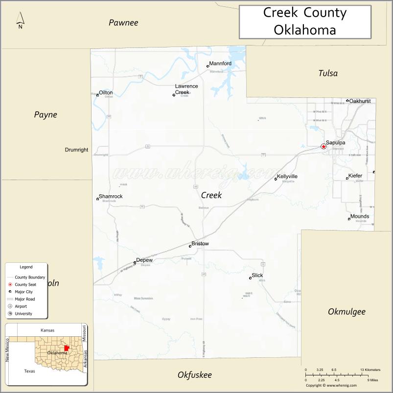
About Creek County Map, Oklahoma: The map showing the county boundary, county seat, major cities, highways, water bodies and neighbouring counties.
Related Oklahoma Maps
About Creek County, Oklahoma
Creek County is a county located in the U.S. state of Oklahoma. It's county seat is Sapulpa. As per 2020 census, the population of Creek County is 72029 people and population density is 75.34 square miles. According to the United States Census Bureau, the county has a total area of 956 sq mi (2,476 km2). Creek County was established on 1907.
Creek County Facts
| Continent | North America |
| Country | United States |
| State | Oklahoma |
| County Seat | Sapulpa |
| Largest City/Town | Sapulpa |
| Established | 1907 |
| Total Area | 970 sq mi (2,512 sq km) |
| Land Area | 950 sq mi (2,461 sq km) |
| Water Area | 20 sq mi (52 sq km) |
| Population | 71,754 (Census 2020) |
| Population Density | 75.5 people per sq mi |
| Time Zone | Central Time Zone (CST/CDT) |
| Major Highways | Interstate 44, State Highway 66, U.S. Route 75A, State Highway 16 |
| Major Rivers | Arkansas River, Cimarron River nearby region, Keystone Lake nearby region |
| Neighboring Counties | Tulsa County, Pawnee County, Okfuskee County, Okmulgee County, Lincoln County, Payne County |
| Famous For | Historic Route 66, oil industry heritage, Keystone Lake recreation, and Creek Nation history |
| Top Attractions | Route 66 attractions, Keystone Lake, Sapulpa Historical Museum, and outdoor recreation areas |
| Official Website | Official Website |
About Creek County, Oklahoma
Creek County is located in northeastern Oklahoma west of Tulsa and was established in 1907 from former Creek Nation territory. The county seat and largest city is Sapulpa. The county is known for Route 66 history, oil production heritage, lakes, rolling hills, and suburban communities near Tulsa.
Cities and Towns in Creek County, Oklahoma
| City/Town | Population (Census 2020) | Latitude & Longitude |
|---|---|---|
| Sapulpa (county seat) | 22,512 | 35.9987°N, 96.1142°W |
| Sand Springs nearby region | 19,879 | 36.1398°N, 96.1089°W |
| Drumright | 2,560 | 35.9917°N, 96.6011°W |
| Bristow | 4,134 | 35.8301°N, 96.3911°W |
| Mannford nearby region | 3,076 | 36.1334°N, 96.3542°W |
| Kiefer | 2,038 | 35.9440°N, 96.0653°W |
Golf Courses in Creek County, Oklahoma
| Golf Course | Location | Latitude & Longitude |
|---|---|---|
| Rock Creek Golf Course | Sapulpa | 36.0091°N, 96.1273°W |
| Cushing Country Club nearby region | Drumright nearby region | 35.9989°N, 96.6124°W |
| Keystone Lake Golf Area | Mannford nearby region | 36.1447°N, 96.3650°W |
Major Roads and Highways in Creek County, Oklahoma
Major highways connect Creek County with Tulsa, central Oklahoma, and Route 66 communities.
- Interstate 44 - major interstate highway through northeastern Oklahoma
- State Highway 66 - historic Route 66 corridor across the county
- U.S. Route 75A - regional transportation route near Tulsa metropolitan areas
- State Highway 16 - connector highway serving rural communities and recreation areas
What are the Neighboring Counties of Creek County
- Pawnee County (northwest)
- Payne County (west)
- Lincoln County (southwest)
- Okfuskee County (south)
- Okmulgee County (southeast)
- Tulsa County (east)
What are the Top Places to Visit in Creek County, Oklahoma
The county offers Route 66 landmarks, lakes, museums, parks, and outdoor recreation opportunities.
- Historic Route 66 Attractions - classic roadside landmarks and travel history sites
- Keystone Lake nearby region - boating, fishing, camping, and water recreation
- Sapulpa Historical Museum - exhibits on oil history and local heritage
- Historic Downtown Sapulpa - shopping, restaurants, and community events
- Drumright Oil Heritage Attractions - early petroleum industry history
- Pretty Water Lake Recreation Area - fishing and outdoor family activities
- Community Festivals and Rodeos - seasonal entertainment and local traditions
- Scenic Creek Nation Countryside Drives - rolling hills and prairie landscapes
- Camping and RV Parks - outdoor recreation and relaxation
- Nature Trails and Wildlife Areas - hiking and environmental exploration
What is the Distance from Creek County to Nearby Cities
The following distances are measured by road (driving).
- Sapulpa to Tulsa (Tulsa County), Oklahoma - 15 mi (24 km)
- Sapulpa to Oklahoma City (Oklahoma County), Oklahoma - 101 mi (163 km)
- Sapulpa to Stillwater (Payne County), Oklahoma - 65 mi (105 km)
- Sapulpa to Muskogee (Muskogee County), Oklahoma - 63 mi (101 km)
- Sapulpa to Bristow (Creek County), Oklahoma - 28 mi (45 km)
- Sapulpa to Drumright (Creek County), Oklahoma - 42 mi (68 km)
- Sapulpa to Fayetteville (Washington County), Arkansas - 121 mi (195 km)
- Sapulpa to Joplin (Jasper County), Missouri - 123 mi (198 km)
- Sapulpa to Dallas (Dallas County), Texas - 267 mi (430 km)
- Sapulpa to Kansas City (Jackson County), Missouri - 256 mi (412 km)
- Sapulpa to Little Rock (Pulaski County), Arkansas - 272 mi (438 km)
- Sapulpa to Denver (Denver County), Colorado - 664 mi (1,069 km)
- Sapulpa to Chicago (Cook County), Illinois - 661 mi (1,064 km)
FAQs about Creek County
Creek County is located in northeastern Oklahoma west of Tulsa.
Creek County had a population of 71,754 according to the 2020 United States Census.
Creek County is known for Route 66 history, oil industry heritage, Keystone Lake, and Creek Nation history.
The county is served by Interstate 44, State Highway 66, U.S. Route 75A, and State Highway 16.
Yes, Creek County includes golf facilities such as Rock Creek Golf Course and recreation golf areas near Keystone Lake.
References
- QuickFacts - U.S. Census Bureau
- United States Census Bureau
- United States Geological Survey (USGS)
- National Geodetic Survey
- Official Website
- Adair County Map
- Alfalfa County Map
- Atoka County Map
- Beaver County Map
- Beckham County Map
- Blaine County Map
- Bryan County Map
- Caddo County Map
- Canadian County Map
- Carter County Map
- Cherokee County Map
- Choctaw County Map
- Cimarron County Map
- Cleveland County Map
- Coal County Map
- Comanche County Map
- Cotton County Map
- Craig County Map
- Creek County Map
- Custer County Map
- Delaware County Map
- Dewey County Map
- Ellis County Map
- Garfield County Map
- Garvin County Map
- Grady County Map
- Grant County Map
- Greer County Map
- Harmon County Map
- Harper County Map
- Haskell County Map
- Hughes County Map
- Jackson County Map
- Jefferson County Map
- Johnston County Map
- Kay County Map
- Kingfisher County Map
- Kiowa County Map
- Latimer County Map
- Le Flore County Map
- Lincoln County Map
- Logan County Map
- Love County Map
- McClain County Map
- McCurtain County Map
- McIntosh County Map
- Major County Map
- Marshall County Map
- Mayes County Map
- Murray County Map
- Muskogee County Map
- Noble County Map
- Nowata County Map
- Okfuskee County Map
- Oklahoma County Map
- Okmulgee County Map
- Osage County Map
- Ottawa County Map
- Pawnee County Map
- Payne County Map
- Pittsburg County Map
- Pontotoc County Map
- Pottawatomie County Map
- Pushmataha County Map
- Roger Mills County Map
- Rogers County Map
- Seminole County Map
- Sequoyah County Map
- Stephens County Map
- Texas County Map
- Tillman County Map
- Tulsa County Map
- Wagoner County Map
- Washington County Map
- Washita County Map
- Woods County Map
- Woodward County Map
- Alabama Counties
- Alaska boroughs
- Arizona Counties
- Arkansas Counties
- California County Map
- Colorado Counties
- Connecticut Counties
- Delaware Counties
- Florida County Map
- Georgia County Map
- Hawaii Counties
- Idaho Counties
- Illinois Counties
- Indiana Counties
- Iowa Counties
- Kansas Counties
- Kentucky Counties
- Louisiana Counties
- Maine Counties
- Maryland Counties
- Massachusetts Counties
- Michigan County Map
- Minnesota Counties
- Mississippi Counties
- Missouri Counties
- Montana Counties
- Nebraska Counties
- Nevada Counties
- New York Counties
- New Hampshire Counties
- New Jersey Counties
- New Mexico Counties
- North Carolina Counties
- North Dakota Counties
- Ohio County Map
- Oklahoma Counties
- Oregon Counties
- Pennsylvania Counties
- Rhode Island Counties
- South Carolina Counties
- South Dakota Counties
- Map of Tennessee
- Texas County Map
- Utah Counties
- Vermont Counties
- Virginia Counties
- Washington Counties
- West Virginia Counties
- Wisconsin Counties
- Wyoming Counties