Written and Fact-checked by Whereig Editors, Reviewed by Mukesh Kumar| Updated On: May 15, 2026
Map of Garvin County - Garvin County is a county located in the U.S. state of Oklahoma. Garvin County Map showing cities, highways, important places and water bodies. Get Where is Garvin County located in the map, major cities in Garvin county, population, areas, and places of interest.
Map of Garvin County, Oklahoma
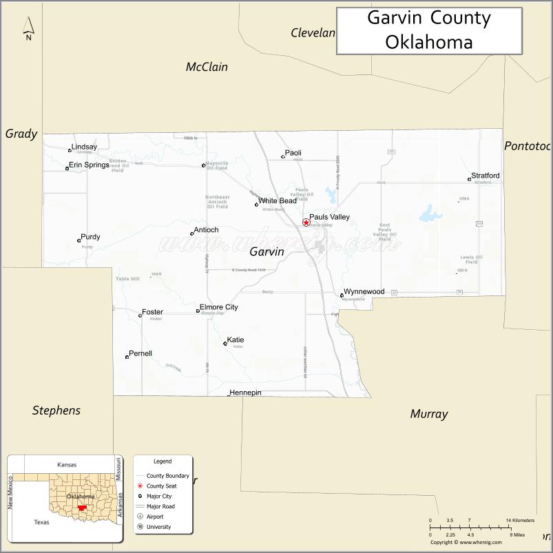
About Garvin County Map, Oklahoma: The map showing the county boundary, county seat, major cities, highways, water bodies and neighbouring counties.
Related Oklahoma Maps
About Garvin County, Oklahoma
Garvin County is a county located in the U.S. state of Oklahoma. It's county seat is Pauls Valley. As per 2020 census, the population of Garvin County is 25804 people and population density is 31.9 square miles. According to the United States Census Bureau, the county has a total area of 809 sq mi (2,095 km2). Garvin County was established on 1907.
Garvin County Facts
| Continent | North America |
| Country | United States |
| State | Oklahoma |
| County Seat | Pauls Valley |
| Largest City/Town | Pauls Valley |
| Established | 1907 |
| Total Area | 814 sq mi (2,108 sq km) |
| Land Area | 802 sq mi (2,077 sq km) |
| Water Area | 12 sq mi (31 sq km) |
| Population | 27,754 (Census 2020) |
| Population Density | 34.6 people per sq mi |
| Time Zone | Central Time Zone (CST/CDT) |
| Major Highways | Interstate 35, U.S. Route 77, State Highway 19 |
| Major Rivers | Washita River, Canadian River nearby region |
| Neighboring Counties | McClain County, Murray County, Pontotoc County, Grady County, Stephens County, Carter County |
| Famous For | Pauls Valley, agricultural production, toy and action figure museum, and south-central Oklahoma landscapes |
| Top Attractions | Toy and Action Figure Museum, Turner Falls nearby region, Washita River recreation, and historic downtown Pauls Valley |
| Official Website | Official Website |
About Garvin County, Oklahoma
Garvin County is located in south-central Oklahoma and was established in 1907 from former Chickasaw Nation lands. The county seat and largest city is Pauls Valley. The county is known for agriculture, small-town heritage, outdoor recreation, and convenient access along Interstate 35.
Cities and Towns in Garvin County, Oklahoma
| City/Town | Population (Census 2020) | Latitude & Longitude |
|---|---|---|
| Pauls Valley (county seat) | 6,078 | 34.7406°N, 97.2222°W |
| Lindsay | 2,840 | 34.8373°N, 97.6028°W |
| Wynnewood | 1,927 | 34.6437°N, 97.1645°W |
| Elmore City | 697 | 34.6220°N, 97.3967°W |
| Maysville | 1,218 | 34.8187°N, 97.4056°W |
| Paoli | 610 | 34.8315°N, 97.2592°W |
Golf Courses in Garvin County, Oklahoma
| Golf Course | Location | Latitude & Longitude |
|---|---|---|
| Pauls Valley Golf & Country Club | Pauls Valley | 34.7529°N, 97.2368°W |
| Lindsay Municipal Golf Course | Lindsay | 34.8486°N, 97.6163°W |
| Wynnewood Community Golf Area | Wynnewood nearby region | 34.6548°N, 97.1789°W |
Major Roads and Highways in Garvin County, Oklahoma
Major highways connect Garvin County with Oklahoma City, southern Oklahoma, and Texas.
- Interstate 35 - major north-south interstate linking Oklahoma City and Dallas
- U.S. Route 77 - historic transportation corridor parallel to Interstate 35
- State Highway 19 - important regional route across south-central Oklahoma
What are the Neighboring Counties of Garvin County
- McClain County (north)
- Grady County (northwest)
- Stephens County (west)
- Carter County (southwest)
- Murray County (south)
- Pontotoc County (east)
What are the Top Places to Visit in Garvin County, Oklahoma
The county offers museums, outdoor recreation, rivers, and family-friendly attractions.
- Toy and Action Figure Museum - unique museum featuring toys, comics, and collectibles
- Historic Downtown Pauls Valley - shopping, restaurants, and local heritage attractions
- Washita River Recreation Areas - fishing, boating, and outdoor activities
- Turner Falls nearby region - waterfalls, hiking, swimming, and scenic recreation
- Wacker Park - community recreation and family picnic facilities
- Community Festivals and Rodeos - seasonal entertainment and local traditions
- Scenic Countryside Drives - farmland and prairie photography opportunities
- Fishing and Wildlife Areas - outdoor recreation and nature observation
- Camping and RV Parks - family recreation and travel accommodations
- Nature Trails and Rural Landscapes - hiking and environmental exploration
What is the Distance from Garvin County to Nearby Cities
The following distances are measured by road (driving).
- Pauls Valley to Oklahoma City (Oklahoma County), Oklahoma - 57 mi (92 km)
- Pauls Valley to Ardmore (Carter County), Oklahoma - 47 mi (76 km)
- Pauls Valley to Norman (Cleveland County), Oklahoma - 36 mi (58 km)
- Pauls Valley to Ada (Pontotoc County), Oklahoma - 43 mi (69 km)
- Pauls Valley to Lindsay (Garvin County), Oklahoma - 28 mi (45 km)
- Pauls Valley to Wynnewood (Garvin County), Oklahoma - 12 mi (19 km)
- Pauls Valley to Tulsa (Tulsa County), Oklahoma - 131 mi (211 km)
- Pauls Valley to Dallas (Dallas County), Texas - 164 mi (264 km)
- Pauls Valley to Wichita (Sedgwick County), Kansas - 218 mi (351 km)
- Pauls Valley to Amarillo (Potter County), Texas - 313 mi (504 km)
- Pauls Valley to Kansas City (Jackson County), Missouri - 352 mi (566 km)
- Pauls Valley to Denver (Denver County), Colorado - 666 mi (1,072 km)
- Pauls Valley to Chicago (Cook County), Illinois - 807 mi (1,299 km)
FAQs about Garvin County
Garvin County is located in south-central Oklahoma.
Garvin County had a population of 27,754 according to the 2020 United States Census.
Garvin County is known for Pauls Valley, agriculture, toy museums, and outdoor recreation.
The county is served by Interstate 35, U.S. Route 77, and State Highway 19.
Yes, Garvin County includes golf facilities such as Pauls Valley Golf & Country Club and Lindsay Municipal Golf Course.
References
- QuickFacts - U.S. Census Bureau
- United States Census Bureau
- United States Geological Survey (USGS)
- National Geodetic Survey
- Official Website
- Adair County Map
- Alfalfa County Map
- Atoka County Map
- Beaver County Map
- Beckham County Map
- Blaine County Map
- Bryan County Map
- Caddo County Map
- Canadian County Map
- Carter County Map
- Cherokee County Map
- Choctaw County Map
- Cimarron County Map
- Cleveland County Map
- Coal County Map
- Comanche County Map
- Cotton County Map
- Craig County Map
- Creek County Map
- Custer County Map
- Delaware County Map
- Dewey County Map
- Ellis County Map
- Garfield County Map
- Garvin County Map
- Grady County Map
- Grant County Map
- Greer County Map
- Harmon County Map
- Harper County Map
- Haskell County Map
- Hughes County Map
- Jackson County Map
- Jefferson County Map
- Johnston County Map
- Kay County Map
- Kingfisher County Map
- Kiowa County Map
- Latimer County Map
- Le Flore County Map
- Lincoln County Map
- Logan County Map
- Love County Map
- McClain County Map
- McCurtain County Map
- McIntosh County Map
- Major County Map
- Marshall County Map
- Mayes County Map
- Murray County Map
- Muskogee County Map
- Noble County Map
- Nowata County Map
- Okfuskee County Map
- Oklahoma County Map
- Okmulgee County Map
- Osage County Map
- Ottawa County Map
- Pawnee County Map
- Payne County Map
- Pittsburg County Map
- Pontotoc County Map
- Pottawatomie County Map
- Pushmataha County Map
- Roger Mills County Map
- Rogers County Map
- Seminole County Map
- Sequoyah County Map
- Stephens County Map
- Texas County Map
- Tillman County Map
- Tulsa County Map
- Wagoner County Map
- Washington County Map
- Washita County Map
- Woods County Map
- Woodward County Map
- Alabama Counties
- Alaska boroughs
- Arizona Counties
- Arkansas Counties
- California County Map
- Colorado Counties
- Connecticut Counties
- Delaware Counties
- Florida County Map
- Georgia County Map
- Hawaii Counties
- Idaho Counties
- Illinois Counties
- Indiana Counties
- Iowa Counties
- Kansas Counties
- Kentucky Counties
- Louisiana Counties
- Maine Counties
- Maryland Counties
- Massachusetts Counties
- Michigan County Map
- Minnesota Counties
- Mississippi Counties
- Missouri Counties
- Montana Counties
- Nebraska Counties
- Nevada Counties
- New York Counties
- New Hampshire Counties
- New Jersey Counties
- New Mexico Counties
- North Carolina Counties
- North Dakota Counties
- Ohio County Map
- Oklahoma Counties
- Oregon Counties
- Pennsylvania Counties
- Rhode Island Counties
- South Carolina Counties
- South Dakota Counties
- Map of Tennessee
- Texas County Map
- Utah Counties
- Vermont Counties
- Virginia Counties
- Washington Counties
- West Virginia Counties
- Wisconsin Counties
- Wyoming Counties