Written and Fact-checked by Whereig Editors, Reviewed by Mukesh Kumar| Updated On: May 15, 2026
Map of Tulsa County - Tulsa County is a county located in the U.S. state of Oklahoma. Tulsa County Map showing cities, highways, important places and water bodies. Get Where is Tulsa County located in the map, major cities in Tulsa county, population, areas, and places of interest.
Map of Tulsa County, Oklahoma
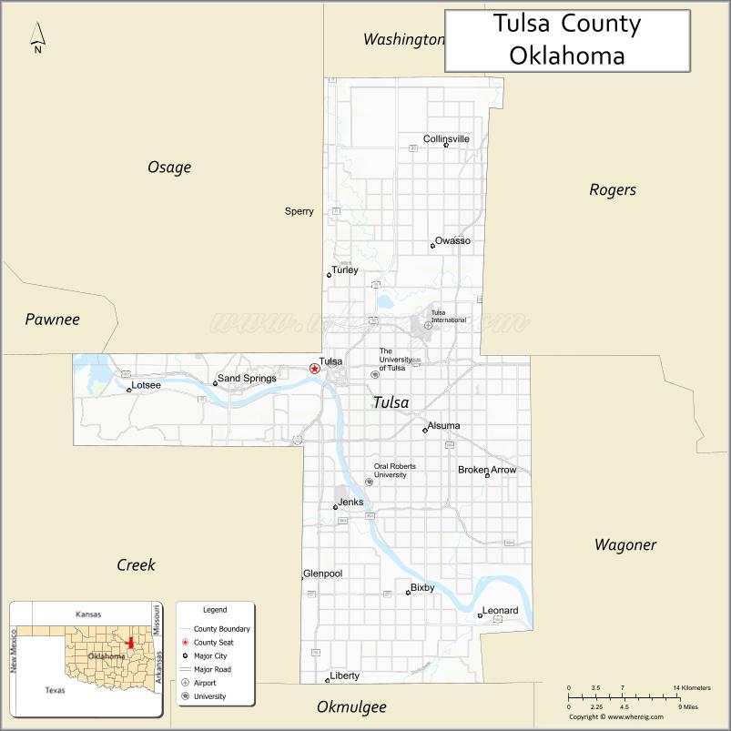
About Tulsa County Map, Oklahoma: The map showing the county boundary, county seat, major cities, highways, water bodies and neighbouring counties.
Related Oklahoma Maps
About Tulsa County, Oklahoma
Tulsa County is a county located in the U.S. state of Oklahoma. It's county seat is Tulsa. As per 2020 census, the population of Tulsa County is 672858 people and population density is 1180.45 square miles. According to the United States Census Bureau, the county has a total area of 570 sq mi (1,476 km2). Tulsa County was established on 1907.
Tulsa County Facts
| Continent | North America |
| Country | United States |
| State | Oklahoma |
| County Seat | Tulsa |
| Largest City/Town | Tulsa |
| Established | 1907 |
| Total Area | 587 sq mi (1,520 sq km) |
| Land Area | 570 sq mi (1,476 sq km) |
| Water Area | 17 sq mi (44 sq km) |
| Population | 669,279 (Census 2020) |
| Population Density | 1,174.2 people per sq mi |
| Time Zone | Central Time Zone |
| Major Highways | Interstate 44, Interstate 244, U.S. Highway 64, U.S. Highway 75, U.S. Highway 169, State Highway 51, Creek Turnpike, Gilcrease Expressway |
| Major Rivers | Arkansas River, Verdigris River, Bird Creek |
| Neighboring Counties | Osage County, Pawnee County, Creek County, Wagoner County, Rogers County, Okmulgee County |
| Famous For | Art Deco architecture, Route 66 history, oil industry heritage, and major cultural attractions |
| Top Attractions | Gathering Place, Philbrook Museum of Art, Tulsa Zoo, Turkey Mountain Urban Wilderness Area, and Route 66 landmarks |
| Official Website | Official Website |
About Tulsa County, Oklahoma
Tulsa County is located in northeastern Oklahoma and was established in 1907 when Oklahoma became a state. The county seat is Tulsa, which is also the largest city and one of the most important economic and cultural centers in Oklahoma. The county features rolling hills, the Arkansas River corridor, major parks, and a strong connection to the historic oil industry and Route 66.
Cities and Towns in Tulsa County, Oklahoma
| City/Town | Population (Census 2020) | Latitude & Longitude |
|---|---|---|
| Tulsa (county seat) | 413,066 | 36.1540°N, 95.9928°W |
| Bixby | 28,609 | 35.9420°N, 95.8833°W |
| Broken Arrow | 113,540 | 36.0609°N, 95.7975°W |
| Collinsville | 6,606 | 36.3645°N, 95.8389°W |
| Glenpool | 14,457 | 35.9554°N, 96.0089°W |
| Jenks | 25,949 | 36.0229°N, 95.9683°W |
| Owasso | 39,328 | 36.2695°N, 95.8547°W |
| Sand Springs | 19,879 | 36.1398°N, 96.1089°W |
| Skiatook | 8,343 | 36.3684°N, 96.0014°W |
| Sperry | 1,149 | 36.2954°N, 95.9914°W |
| Turley (CDP) | 2,756 | 36.2420°N, 95.9750°W |
| Liberty (CDP) | 2,840 | 36.0190°N, 95.9075°W |
| Catoosa | 7,159 | 36.1884°N, 95.7458°W |
| Lotsee | 5 | 36.1336°N, 96.2097°W |
| Verdigris | 5,328 | 36.2337°N, 95.6914°W |
Golf Courses in Tulsa County, Oklahoma
| Golf Course | Location | Latitude & Longitude |
|---|---|---|
| Southern Hills Country Club | Tulsa | 36.0825°N, 95.9556°W |
| Tulsa Country Club | Tulsa | 36.1269°N, 95.9298°W |
| LaFortune Park Golf Course | Tulsa | 36.1044°N, 95.9206°W |
| Page Belcher Golf Course | Tulsa | 36.1042°N, 96.0718°W |
| Battle Creek Golf Club | Broken Arrow | 36.0401°N, 95.7458°W |
| Forest Ridge Golf Club | Broken Arrow | 36.0498°N, 95.7008°W |
| MeadowBrook Country Club | Tulsa | 36.1215°N, 95.8698°W |
| The Golf Club of Oklahoma | Broken Arrow | 36.0005°N, 95.6860°W |
| Bailey Ranch Golf Club | Owasso | 36.3070°N, 95.8430°W |
| Mohawk Park Golf Course | Tulsa | 36.2158°N, 95.9146°W |
| South Lakes Golf Course | Jenks | 36.0164°N, 95.9734°W |
| The Canyons at Blackjack Ridge | Sand Springs | 36.1289°N, 96.1707°W |
Major Roads and Highways in Tulsa County, Oklahoma
Major highways connect the county to nearby regions and cities.
- Interstate 44 - major east-west route connecting Tulsa with Oklahoma City and Missouri
- Interstate 244 - loop highway serving downtown Tulsa and surrounding districts
- U.S. Highway 64 - regional highway connecting Tulsa with western and eastern Oklahoma
- U.S. Highway 75 - north-south corridor linking Tulsa with Okmulgee and Kansas
- U.S. Highway 169 - major commuter route through eastern Tulsa County
- State Highway 51 - connects Tulsa with Broken Arrow and Stillwater areas
- Creek Turnpike - toll road serving southern Tulsa County suburbs
- Gilcrease Expressway - western bypass around Tulsa metropolitan area
What are the Neighboring Counties of Tulsa County
- Osage County (northwest)
- Pawnee County (west)
- Creek County (southwest)
- Okmulgee County (south)
- Wagoner County (east)
- Rogers County (northeast)
What are the Top Places to Visit in Tulsa County, Oklahoma
The county offers a mix of natural and cultural attractions.
- Gathering Place - nationally recognized riverfront park with trails, gardens, and playgrounds
- Philbrook Museum of Art - historic mansion museum with fine art collections and gardens
- Tulsa Zoo - major zoo featuring wildlife exhibits and conservation programs
- Turkey Mountain Urban Wilderness Area - popular hiking and biking destination with scenic trails
- Gilcrease Museum - museum focused on American West history and Native American art
- Golden Driller - iconic Tulsa landmark honoring the region's oil heritage
- Route 66 Historical Village - historic Route 66 attraction with vintage transportation exhibits
- Woodward Park and Gardens - botanical garden and public park in Tulsa
- ONEOK Field - downtown baseball stadium home to the Tulsa Drillers
- Oklahoma Aquarium - large aquarium located in Jenks with shark exhibits and marine life displays
- Cain's Ballroom - famous historic music venue known for country and rock performances
- Tulsa Air and Space Museum - aviation museum with aircraft displays and simulators
- Keystone Lake - nearby recreation area popular for boating and fishing
- BOK Center - major sports and entertainment arena in downtown Tulsa
What is the Distance from Tulsa County to Nearby Cities
The following distances are measured by road (driving).
- Tulsa to Oklahoma City (Oklahoma County), Oklahoma - 106 mi (171 km)
- Tulsa to Broken Arrow (Tulsa County), Oklahoma - 13 mi (21 km)
- Tulsa to Owasso (Tulsa County), Oklahoma - 14 mi (23 km)
- Tulsa to Bartlesville (Washington County), Oklahoma - 47 mi (76 km)
- Tulsa to Muskogee (Muskogee County), Oklahoma - 49 mi (79 km)
- Tulsa to Stillwater (Payne County), Oklahoma - 73 mi (117 km)
- Tulsa to Joplin (Jasper County), Missouri - 116 mi (187 km)
- Tulsa to Fayetteville (Washington County), Arkansas - 118 mi (190 km)
- Tulsa to McAlester (Pittsburg County), Oklahoma - 92 mi (148 km)
- Tulsa to Ponca City (Kay County), Oklahoma - 102 mi (164 km)
- Tulsa to Wichita (Sedgwick County), Kansas - 178 mi (286 km)
- Tulsa to Fort Smith (Sebastian County), Arkansas - 108 mi (174 km)
- Tulsa to Norman (Cleveland County), Oklahoma - 121 mi (195 km)
- Tulsa to Claremore (Rogers County), Oklahoma - 29 mi (47 km)
- Tulsa to Sapulpa (Creek County), Oklahoma - 15 mi (24 km)
FAQs about Tulsa County
Tulsa County is located in northeastern Oklahoma and is part of the Tulsa metropolitan area.
The population of Tulsa County was 669,279 according to the Census 2020.
Tulsa County is known for its Art Deco architecture, oil industry history, Route 66 attractions, and cultural landmarks.
The county is served by Interstate 44, Interstate 244, U.S. Highway 64, U.S. Highway 75, and several major state highways and turnpikes.
Yes, Tulsa County has many golf courses including Southern Hills Country Club, Forest Ridge Golf Club, and Page Belcher Golf Course.
References
- QuickFacts - U.S. Census Bureau
- United States Census Bureau
- United States Geological Survey (USGS)
- National Geodetic Survey
- Official County Website
- Adair County Map
- Alfalfa County Map
- Atoka County Map
- Beaver County Map
- Beckham County Map
- Blaine County Map
- Bryan County Map
- Caddo County Map
- Canadian County Map
- Carter County Map
- Cherokee County Map
- Choctaw County Map
- Cimarron County Map
- Cleveland County Map
- Coal County Map
- Comanche County Map
- Cotton County Map
- Craig County Map
- Creek County Map
- Custer County Map
- Delaware County Map
- Dewey County Map
- Ellis County Map
- Garfield County Map
- Garvin County Map
- Grady County Map
- Grant County Map
- Greer County Map
- Harmon County Map
- Harper County Map
- Haskell County Map
- Hughes County Map
- Jackson County Map
- Jefferson County Map
- Johnston County Map
- Kay County Map
- Kingfisher County Map
- Kiowa County Map
- Latimer County Map
- Le Flore County Map
- Lincoln County Map
- Logan County Map
- Love County Map
- McClain County Map
- McCurtain County Map
- McIntosh County Map
- Major County Map
- Marshall County Map
- Mayes County Map
- Murray County Map
- Muskogee County Map
- Noble County Map
- Nowata County Map
- Okfuskee County Map
- Oklahoma County Map
- Okmulgee County Map
- Osage County Map
- Ottawa County Map
- Pawnee County Map
- Payne County Map
- Pittsburg County Map
- Pontotoc County Map
- Pottawatomie County Map
- Pushmataha County Map
- Roger Mills County Map
- Rogers County Map
- Seminole County Map
- Sequoyah County Map
- Stephens County Map
- Texas County Map
- Tillman County Map
- Tulsa County Map
- Wagoner County Map
- Washington County Map
- Washita County Map
- Woods County Map
- Woodward County Map
- Alabama Counties
- Alaska boroughs
- Arizona Counties
- Arkansas Counties
- California County Map
- Colorado Counties
- Connecticut Counties
- Delaware Counties
- Florida County Map
- Georgia County Map
- Hawaii Counties
- Idaho Counties
- Illinois Counties
- Indiana Counties
- Iowa Counties
- Kansas Counties
- Kentucky Counties
- Louisiana Counties
- Maine Counties
- Maryland Counties
- Massachusetts Counties
- Michigan County Map
- Minnesota Counties
- Mississippi Counties
- Missouri Counties
- Montana Counties
- Nebraska Counties
- Nevada Counties
- New York Counties
- New Hampshire Counties
- New Jersey Counties
- New Mexico Counties
- North Carolina Counties
- North Dakota Counties
- Ohio County Map
- Oklahoma Counties
- Oregon Counties
- Pennsylvania Counties
- Rhode Island Counties
- South Carolina Counties
- South Dakota Counties
- Map of Tennessee
- Texas County Map
- Utah Counties
- Vermont Counties
- Virginia Counties
- Washington Counties
- West Virginia Counties
- Wisconsin Counties
- Wyoming Counties