Written and Fact-checked by Whereig Editors, Reviewed by Mukesh Kumar| Updated On: May 15, 2026
Map of Cimarron County - Cimarron County is a county located in the U.S. state of Oklahoma. Cimarron County Map showing cities, highways, important places and water bodies. Get Where is Cimarron County located in the map, major cities in Cimarron county, population, areas, and places of interest.
Map of Cimarron County, Oklahoma
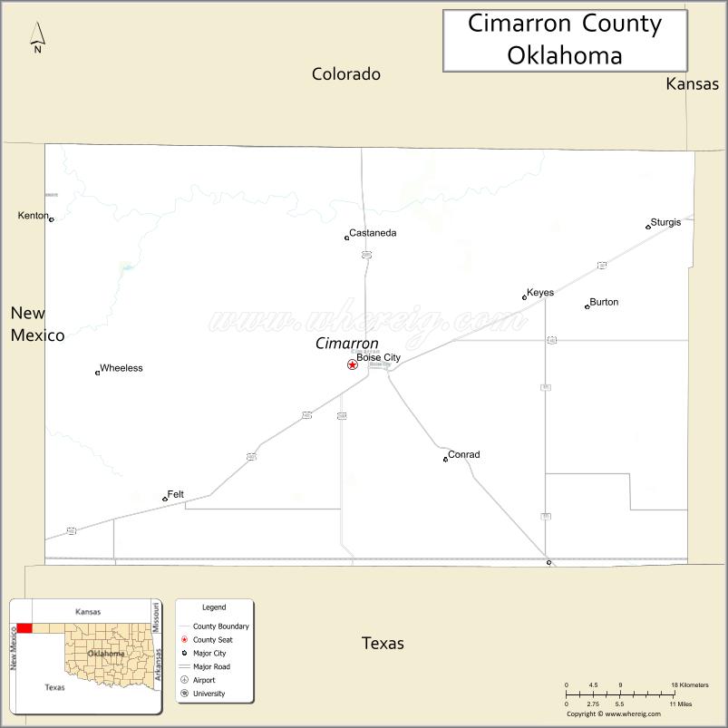
About Cimarron County Map, Oklahoma: The map showing the county boundary, county seat, major cities, highways, water bodies and neighbouring counties.
Related Oklahoma Maps
About Cimarron County, Oklahoma
Cimarron County is a county located in the U.S. state of Oklahoma. It's county seat is Boise City. As per 2020 census, the population of Cimarron County is 2248 people and population density is 1.23 square miles. According to the United States Census Bureau, the county has a total area of 1,835 sq mi (4,753 km2). Cimarron County was established on 1907.
Cimarron County Facts
| Continent | North America |
| Country | United States |
| State | Oklahoma |
| County Seat | Boise City |
| Largest City/Town | Boise City |
| Established | 1907 |
| Total Area | 1,841 sq mi (4,768 sq km) |
| Land Area | 1,835 sq mi (4,753 sq km) |
| Water Area | 6 sq mi (16 sq km) |
| Population | 2,184 (Census 2020) |
| Population Density | 1.2 people per sq mi |
| Time Zone | Central Time Zone (CST/CDT) |
| Major Highways | U.S. Route 287, U.S. Route 385, U.S. Route 56, State Highway 3 |
| Major Rivers | Cimarron River, Beaver River nearby region |
| Neighboring Counties | Texas County, Union County (New Mexico), Baca County (Colorado), Morton County (Kansas), Dallam County (Texas) |
| Famous For | Black Mesa, Oklahoma Panhandle landscapes, dinosaur tracks, and western frontier history |
| Top Attractions | Black Mesa State Park, Black Mesa Nature Preserve, dinosaur trackways, and Santa Fe Trail history |
| Official Website | Official Website |
About Cimarron County, Oklahoma
Cimarron County is located in the far western Oklahoma Panhandle and is the only Oklahoma county that borders four different states. The county seat and largest town is Boise City. The county is known for Black Mesa, high plains scenery, dinosaur fossil sites, ranching, and western frontier heritage.
Cities and Towns in Cimarron County, Oklahoma
| City/Town | Population (Census 2020) | Latitude & Longitude |
|---|---|---|
| Boise City (county seat) | 1,166 | 36.7295°N, 102.5130°W |
| Keyes | 276 | 36.8061°N, 102.2391°W |
| Kenton | 17 | 36.9014°N, 102.9630°W |
| Felt | 74 | 36.5667°N, 102.7841°W |
| Griggs nearby region | 58 | 36.3498°N, 102.4925°W |
| Sturgis nearby area | 22 | 36.8775°N, 102.5658°W |
Golf Courses in Cimarron County, Oklahoma
| Golf Course | Location | Latitude & Longitude |
|---|---|---|
| Boise City Golf Course | Boise City | 36.7388°N, 102.5267°W |
| Black Mesa Recreation Golf Area | Kenton nearby region | 36.9124°N, 102.9755°W |
| Panhandle Plains Golf Area | Keyes nearby region | 36.8179°N, 102.2526°W |
Major Roads and Highways in Cimarron County, Oklahoma
Major highways connect Cimarron County with the Oklahoma Panhandle, Colorado, New Mexico, Kansas, and Texas.
- U.S. Route 287 - major north-south transportation route through the High Plains
- U.S. Route 385 - regional highway linking Oklahoma, Colorado, and Texas
- U.S. Route 56 - east-west highway serving western Kansas and the Panhandle
- State Highway 3 - important Oklahoma Panhandle transportation corridor
What are the Neighboring Counties of Cimarron County
- Morton County, Kansas (north)
- Baca County, Colorado (northwest)
- Union County, New Mexico (west)
- Dallam County, Texas (south)
- Texas County (east)
What are the Top Places to Visit in Cimarron County, Oklahoma
The county offers high plains scenery, hiking, fossil sites, and western heritage attractions.
- Black Mesa State Park - hiking, camping, fishing, and scenic mountain views
- Black Mesa Nature Preserve - Oklahoma's highest point and unique desert landscapes
- Dinosaur Trackways nearby region - preserved prehistoric fossil footprints
- Santa Fe Trail Historic Areas - frontier history and pioneer travel routes
- Cimarron Heritage Center Museum - regional history and western exhibits
- High Plains Scenic Drives - open landscapes and photography opportunities
- Dark Sky Stargazing Areas - astronomy and night-sky observation
- Camping and RV Parks - outdoor recreation and western exploration
- Wildlife Observation Areas - prairie birds and grassland animals
- Historic Downtown Boise City - local shops and Panhandle heritage attractions
What is the Distance from Cimarron County to Nearby Cities
The following distances are measured by road (driving).
- Boise City to Guymon (Texas County), Oklahoma - 81 mi (130 km)
- Boise City to Amarillo (Potter County), Texas - 141 mi (227 km)
- Boise City to Trinidad (Las Animas County), Colorado - 146 mi (235 km)
- Boise City to Clayton (Union County), New Mexico - 63 mi (101 km)
- Boise City to Keyes (Cimarron County), Oklahoma - 17 mi (27 km)
- Boise City to Kenton (Cimarron County), Oklahoma - 36 mi (58 km)
- Boise City to Oklahoma City (Oklahoma County), Oklahoma - 330 mi (531 km)
- Boise City to Denver (Denver County), Colorado - 298 mi (480 km)
- Boise City to Albuquerque (Bernalillo County), New Mexico - 285 mi (459 km)
- Boise City to Dallas (Dallas County), Texas - 438 mi (705 km)
- Boise City to Kansas City (Jackson County), Missouri - 541 mi (871 km)
- Boise City to Wichita (Sedgwick County), Kansas - 284 mi (457 km)
- Boise City to Chicago (Cook County), Illinois - 918 mi (1,477 km)
FAQs about Cimarron County
Cimarron County is located in the far western Oklahoma Panhandle.
Cimarron County had a population of 2,184 according to the 2020 United States Census.
Cimarron County is known for Black Mesa, dinosaur tracks, western frontier history, and high plains landscapes.
The county is served by U.S. Route 287, U.S. Route 385, U.S. Route 56, and State Highway 3.
Yes, Cimarron County includes golf and recreation facilities near Boise City and Black Mesa.
References
- QuickFacts - U.S. Census Bureau
- United States Census Bureau
- United States Geological Survey (USGS)
- National Geodetic Survey
- Official Website
- Adair County Map
- Alfalfa County Map
- Atoka County Map
- Beaver County Map
- Beckham County Map
- Blaine County Map
- Bryan County Map
- Caddo County Map
- Canadian County Map
- Carter County Map
- Cherokee County Map
- Choctaw County Map
- Cimarron County Map
- Cleveland County Map
- Coal County Map
- Comanche County Map
- Cotton County Map
- Craig County Map
- Creek County Map
- Custer County Map
- Delaware County Map
- Dewey County Map
- Ellis County Map
- Garfield County Map
- Garvin County Map
- Grady County Map
- Grant County Map
- Greer County Map
- Harmon County Map
- Harper County Map
- Haskell County Map
- Hughes County Map
- Jackson County Map
- Jefferson County Map
- Johnston County Map
- Kay County Map
- Kingfisher County Map
- Kiowa County Map
- Latimer County Map
- Le Flore County Map
- Lincoln County Map
- Logan County Map
- Love County Map
- McClain County Map
- McCurtain County Map
- McIntosh County Map
- Major County Map
- Marshall County Map
- Mayes County Map
- Murray County Map
- Muskogee County Map
- Noble County Map
- Nowata County Map
- Okfuskee County Map
- Oklahoma County Map
- Okmulgee County Map
- Osage County Map
- Ottawa County Map
- Pawnee County Map
- Payne County Map
- Pittsburg County Map
- Pontotoc County Map
- Pottawatomie County Map
- Pushmataha County Map
- Roger Mills County Map
- Rogers County Map
- Seminole County Map
- Sequoyah County Map
- Stephens County Map
- Texas County Map
- Tillman County Map
- Tulsa County Map
- Wagoner County Map
- Washington County Map
- Washita County Map
- Woods County Map
- Woodward County Map
- Alabama Counties
- Alaska boroughs
- Arizona Counties
- Arkansas Counties
- California County Map
- Colorado Counties
- Connecticut Counties
- Delaware Counties
- Florida County Map
- Georgia County Map
- Hawaii Counties
- Idaho Counties
- Illinois Counties
- Indiana Counties
- Iowa Counties
- Kansas Counties
- Kentucky Counties
- Louisiana Counties
- Maine Counties
- Maryland Counties
- Massachusetts Counties
- Michigan County Map
- Minnesota Counties
- Mississippi Counties
- Missouri Counties
- Montana Counties
- Nebraska Counties
- Nevada Counties
- New York Counties
- New Hampshire Counties
- New Jersey Counties
- New Mexico Counties
- North Carolina Counties
- North Dakota Counties
- Ohio County Map
- Oklahoma Counties
- Oregon Counties
- Pennsylvania Counties
- Rhode Island Counties
- South Carolina Counties
- South Dakota Counties
- Map of Tennessee
- Texas County Map
- Utah Counties
- Vermont Counties
- Virginia Counties
- Washington Counties
- West Virginia Counties
- Wisconsin Counties
- Wyoming Counties