Written and Fact-checked by Whereig Editors, Reviewed by Mukesh Kumar| Updated On: May 15, 2026
Map of Ottawa County - Ottawa County is a county located in the U.S. state of Oklahoma. Ottawa County Map showing cities, highways, important places and water bodies. Get Where is Ottawa County located in the map, major cities in Ottawa county, population, areas, and places of interest.
Map of Ottawa County, Oklahoma
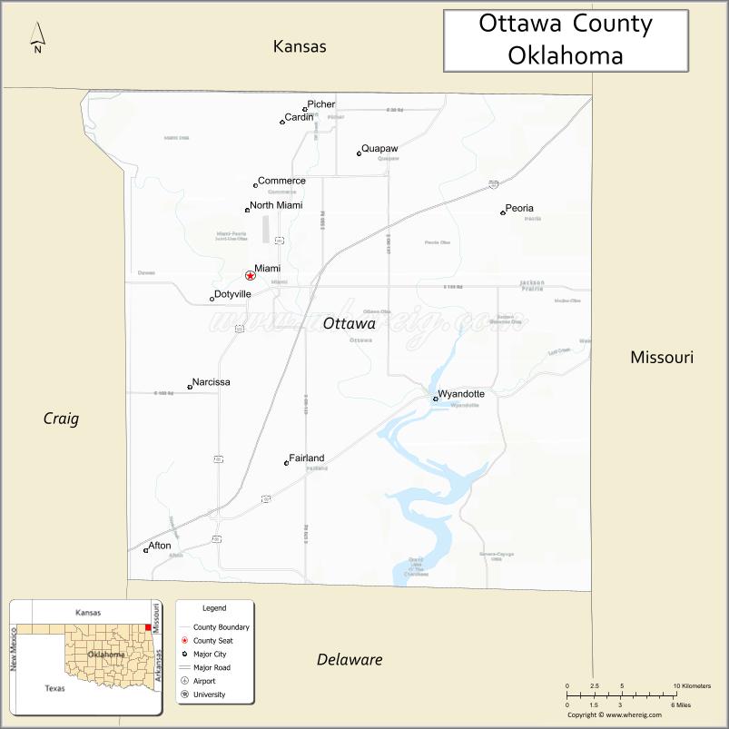
About Ottawa County Map, Oklahoma: The map showing the county boundary, county seat, major cities, highways, water bodies and neighbouring counties.
Related Oklahoma Maps
About Ottawa County, Oklahoma
Ottawa County is a county located in the U.S. state of Oklahoma. It's county seat is Miami. As per 2020 census, the population of Ottawa County is 30340 people and population density is 64.42 square miles. According to the United States Census Bureau, the county has a total area of 471 sq mi (1,220 km2). Ottawa County was established on 1907.
Ottawa County Facts
| Continent | North America |
| Country | United States |
| State | Oklahoma |
| County Seat | Miami |
| Largest City/Town | Miami |
| Established | 1907 |
| Total Area | 485 sq mi (1,256 sq km) |
| Land Area | 471 sq mi (1,220 sq km) |
| Water Area | 14 sq mi (36 sq km) |
| Population | 30,285 (Census 2020) |
| Population Density | 64.3 people per sq mi |
| Time Zone | Central Time Zone (CST/CDT) |
| Major Highways | Interstate 44, U.S. Route 59, U.S. Route 69, Historic Route 66 |
| Major Rivers | Neosho River, Spring River, Grand River nearby region |
| Neighboring Counties | Craig County, Delaware County, Cherokee County (Kansas), Jasper County (Missouri), Newton County (Missouri) |
| Famous For | Route 66 heritage, Native American culture, mining history, and casino tourism |
| Top Attractions | Route 66 attractions, Miami historic district, Downstream Casino nearby region, and Twin Bridges State Park |
| Official Website | Official Website |
About Ottawa County, Oklahoma
Ottawa County is located in northeastern Oklahoma in the state's corner region near Kansas and Missouri. Established in 1907 from former Quapaw Agency lands, the county seat and largest city is Miami. The county is known for Route 66 heritage, Native American history, mining traditions, tourism, and outdoor recreation.
Cities and Towns in Ottawa County, Oklahoma
| City/Town | Population (Census 2020) | Latitude & Longitude |
|---|---|---|
| Miami (county seat) | 12,900 | 36.8745°N, 94.8775°W |
| Commerce | 2,337 | 36.9334°N, 94.8736°W |
| Picher nearby region | 20 | 36.9820°N, 94.8261°W |
| Quapaw | 906 | 36.9562°N, 94.7877°W |
| Wyandotte | 387 | 36.7954°N, 94.7249°W |
| Afton nearby region | 1,049 | 36.6951°N, 94.9630°W |
Golf Courses in Ottawa County, Oklahoma
| Golf Course | Location | Latitude & Longitude |
|---|---|---|
| Miami Golf and Country Club | Miami | 36.8894°N, 94.8952°W |
| Peoria Ridge Golf Course | Quapaw nearby region | 36.9686°N, 94.7724°W |
| Afton Recreation Golf Area | Afton nearby region | 36.7058°N, 94.9756°W |
Major Roads and Highways in Ottawa County, Oklahoma
Major highways connect Ottawa County with Kansas, Missouri, and northeastern Oklahoma tourism destinations.
- Interstate 44 - major interstate corridor across northeastern Oklahoma
- U.S. Route 59 - important north-south transportation route
- U.S. Route 69 - regional highway connecting Oklahoma and Kansas
- Historic Route 66 - iconic highway passing through Miami and nearby communities
What are the Neighboring Counties of Ottawa County
- Cherokee County, Kansas (north)
- Jasper County, Missouri (east)
- Newton County, Missouri (southeast)
- Delaware County (south)
- Craig County (west)
What are the Top Places to Visit in Ottawa County, Oklahoma
The county offers Route 66 history, Native American heritage, casinos, parks, and outdoor recreation opportunities.
- Historic Route 66 Attractions - vintage motels, murals, and roadside landmarks
- Downstream Casino Resort nearby region - entertainment, gaming, dining, and concerts
- Twin Bridges State Park - boating, fishing, camping, and recreation areas
- Historic Downtown Miami - architecture, restaurants, and local shops
- Peoria Ridge Golf Course - championship golf and scenic landscapes
- Mining Heritage Sites - history of lead and zinc mining in the Tri-State district
- Fishing and Wildlife Areas - birdwatching and outdoor exploration
- Native American Cultural Sites - tribal heritage and community attractions
- Community Festivals and Route 66 Events - seasonal entertainment and tourism celebrations
- Nature Trails and Scenic Drives - countryside landscapes and photography opportunities
What is the Distance from Ottawa County to Nearby Cities
The following distances are measured by road (driving).
- Miami to Joplin (Jasper County), Missouri - 27 mi (43 km)
- Miami to Tulsa (Tulsa County), Oklahoma - 91 mi (146 km)
- Miami to Fayetteville (Washington County), Arkansas - 86 mi (138 km)
- Miami to Kansas City (Jackson County), Missouri - 164 mi (264 km)
- Miami to Commerce (Ottawa County), Oklahoma - 5 mi (8 km)
- Miami to Quapaw (Ottawa County), Oklahoma - 10 mi (16 km)
- Miami to Springfield (Greene County), Missouri - 112 mi (180 km)
- Miami to Oklahoma City (Oklahoma County), Oklahoma - 214 mi (344 km)
- Miami to Little Rock (Pulaski County), Arkansas - 243 mi (391 km)
- Miami to Dallas (Dallas County), Texas - 339 mi (546 km)
- Miami to Amarillo (Potter County), Texas - 504 mi (811 km)
- Miami to Denver (Denver County), Colorado - 684 mi (1,101 km)
- Miami to Chicago (Cook County), Illinois - 560 mi (901 km)
FAQs about Ottawa County
Ottawa County is located in northeastern Oklahoma near the Kansas and Missouri borders.
Ottawa County had a population of 30,285 according to the 2020 United States Census.
Ottawa County is known for Route 66 heritage, Native American culture, mining history, and tourism attractions.
The county is served by Interstate 44, U.S. Route 59, U.S. Route 69, and historic Route 66.
Yes, Ottawa County includes golf facilities such as Miami Golf and Country Club and Peoria Ridge Golf Course.
References
- QuickFacts - U.S. Census Bureau
- United States Census Bureau
- United States Geological Survey (USGS)
- National Geodetic Survey
- Official Website
- Adair County Map
- Alfalfa County Map
- Atoka County Map
- Beaver County Map
- Beckham County Map
- Blaine County Map
- Bryan County Map
- Caddo County Map
- Canadian County Map
- Carter County Map
- Cherokee County Map
- Choctaw County Map
- Cimarron County Map
- Cleveland County Map
- Coal County Map
- Comanche County Map
- Cotton County Map
- Craig County Map
- Creek County Map
- Custer County Map
- Delaware County Map
- Dewey County Map
- Ellis County Map
- Garfield County Map
- Garvin County Map
- Grady County Map
- Grant County Map
- Greer County Map
- Harmon County Map
- Harper County Map
- Haskell County Map
- Hughes County Map
- Jackson County Map
- Jefferson County Map
- Johnston County Map
- Kay County Map
- Kingfisher County Map
- Kiowa County Map
- Latimer County Map
- Le Flore County Map
- Lincoln County Map
- Logan County Map
- Love County Map
- McClain County Map
- McCurtain County Map
- McIntosh County Map
- Major County Map
- Marshall County Map
- Mayes County Map
- Murray County Map
- Muskogee County Map
- Noble County Map
- Nowata County Map
- Okfuskee County Map
- Oklahoma County Map
- Okmulgee County Map
- Osage County Map
- Ottawa County Map
- Pawnee County Map
- Payne County Map
- Pittsburg County Map
- Pontotoc County Map
- Pottawatomie County Map
- Pushmataha County Map
- Roger Mills County Map
- Rogers County Map
- Seminole County Map
- Sequoyah County Map
- Stephens County Map
- Texas County Map
- Tillman County Map
- Tulsa County Map
- Wagoner County Map
- Washington County Map
- Washita County Map
- Woods County Map
- Woodward County Map
- Alabama Counties
- Alaska boroughs
- Arizona Counties
- Arkansas Counties
- California County Map
- Colorado Counties
- Connecticut Counties
- Delaware Counties
- Florida County Map
- Georgia County Map
- Hawaii Counties
- Idaho Counties
- Illinois Counties
- Indiana Counties
- Iowa Counties
- Kansas Counties
- Kentucky Counties
- Louisiana Counties
- Maine Counties
- Maryland Counties
- Massachusetts Counties
- Michigan County Map
- Minnesota Counties
- Mississippi Counties
- Missouri Counties
- Montana Counties
- Nebraska Counties
- Nevada Counties
- New York Counties
- New Hampshire Counties
- New Jersey Counties
- New Mexico Counties
- North Carolina Counties
- North Dakota Counties
- Ohio County Map
- Oklahoma Counties
- Oregon Counties
- Pennsylvania Counties
- Rhode Island Counties
- South Carolina Counties
- South Dakota Counties
- Map of Tennessee
- Texas County Map
- Utah Counties
- Vermont Counties
- Virginia Counties
- Washington Counties
- West Virginia Counties
- Wisconsin Counties
- Wyoming Counties