Written and Fact-checked by Whereig Editors, Reviewed by Mukesh Kumar| Updated On: May 15, 2026
Map of Garfield County - Garfield County is a county located in the U.S. state of Oklahoma. Garfield County Map showing cities, highways, important places and water bodies. Get Where is Garfield County located in the map, major cities in Garfield county, population, areas, and places of interest.
Map of Garfield County, Oklahoma
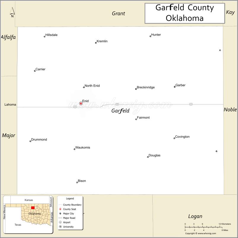
About Garfield County Map, Oklahoma: The map showing the county boundary, county seat, major cities, highways, water bodies and neighbouring counties.
Related Oklahoma Maps
About Garfield County, Oklahoma
Garfield County is a county located in the U.S. state of Oklahoma. It's county seat is Enid. As per 2020 census, the population of Garfield County is 61926 people and population density is 58.53 square miles. According to the United States Census Bureau, the county has a total area of 1,058 sq mi (2,740 km2). Garfield County was established on 1893.
Garfield County Facts
| Continent | North America |
| Country | United States |
| State | Oklahoma |
| County Seat | Enid |
| Largest City/Town | Enid |
| Established | 1893 |
| Total Area | 1,060 sq mi (2,745 sq km) |
| Land Area | 1,058 sq mi (2,740 sq km) |
| Water Area | 2 sq mi (5 sq km) |
| Population | 61,090 (Census 2020) |
| Population Density | 57.7 people per sq mi |
| Time Zone | Central Time Zone (CST/CDT) |
| Major Highways | U.S. Route 81, U.S. Route 60, State Highway 412, U.S. Route 64 |
| Major Rivers | Cimarron River nearby region, Skeleton Creek, Turkey Creek |
| Neighboring Counties | Grant County, Kay County, Noble County, Logan County, Kingfisher County, Major County, Alfalfa County |
| Famous For | Enid, wheat production, Vance Air Force Base, and north-central Oklahoma agriculture |
| Top Attractions | Leonardo's Children's Museum, Railroad Museum of Oklahoma, Vance Air Force Base, and downtown Enid |
| Official Website | Official Website |
About Garfield County, Oklahoma
Garfield County is located in north-central Oklahoma and was established during the Cherokee Outlet Land Run of 1893. The county seat and largest city is Enid. The county is known for wheat farming, aviation training, oil production, and its role as a major agricultural center in Oklahoma.
Cities and Towns in Garfield County, Oklahoma
| City/Town | Population (Census 2020) | Latitude & Longitude |
|---|---|---|
| Enid (county seat) | 51,308 | 36.3956°N, 97.8784°W |
| Garber | 822 | 36.4364°N, 97.5853°W |
| Waukomis | 1,286 | 36.2806°N, 97.8992°W |
| North Enid | 860 | 36.4325°N, 97.8678°W |
| Kremlin | 255 | 36.5489°N, 97.8339°W |
| Carrier nearby region | 79 | 36.4561°N, 98.0203°W |
Golf Courses in Garfield County, Oklahoma
| Golf Course | Location | Latitude & Longitude |
|---|---|---|
| Pheasant Run Golf Club | Enid | 36.4088°N, 97.9026°W |
| Meadowlake Golf Course | Enid | 36.3762°N, 97.8574°W |
| Willow View Golf Course | Kremlin nearby region | 36.5581°N, 97.8457°W |
Major Roads and Highways in Garfield County, Oklahoma
Major highways connect Garfield County with Oklahoma City, Kansas, and agricultural regions across north-central Oklahoma.
- U.S. Route 81 - major north-south transportation route through Oklahoma and Kansas
- U.S. Route 60 - important east-west highway across northern Oklahoma
- State Highway 412 - major regional corridor linking western and northeastern Oklahoma
- U.S. Route 64 - transportation route serving Enid and surrounding communities
What are the Neighboring Counties of Garfield County
- Grant County (north)
- Kay County (northeast)
- Noble County (east)
- Logan County (south)
- Kingfisher County (southwest)
- Major County (west)
- Alfalfa County (northwest)
What are the Top Places to Visit in Garfield County, Oklahoma
The county offers museums, aviation history, parks, and agricultural heritage attractions.
- Leonardo's Children's Museum - interactive exhibits and family activities
- Railroad Museum of Oklahoma - railroad history and historic train displays
- Vance Air Force Base - aviation training facility and military heritage
- Historic Downtown Enid - shopping, dining, and entertainment venues
- Cherokee Strip Regional Heritage Center - exhibits on the Land Run and pioneer history
- Meadowlake Park - outdoor recreation, walking trails, and sports facilities
- Community Festivals and Concerts - seasonal entertainment and local events
- Prairie Scenic Drives - agricultural landscapes and countryside photography
- Fishing and Recreation Areas - family outdoor activities and relaxation
- Arts and Cultural Venues - galleries, theaters, and local performances
What is the Distance from Garfield County to Nearby Cities
The following distances are measured by road (driving).
- Enid to Oklahoma City (Oklahoma County), Oklahoma - 98 mi (158 km)
- Enid to Stillwater (Payne County), Oklahoma - 70 mi (113 km)
- Enid to Wichita (Sedgwick County), Kansas - 113 mi (182 km)
- Enid to Woodward (Woodward County), Oklahoma - 85 mi (137 km)
- Enid to Waukomis (Garfield County), Oklahoma - 8 mi (13 km)
- Enid to Garber (Garfield County), Oklahoma - 24 mi (39 km)
- Enid to Tulsa (Tulsa County), Oklahoma - 145 mi (233 km)
- Enid to Amarillo (Potter County), Texas - 247 mi (398 km)
- Enid to Dallas (Dallas County), Texas - 293 mi (472 km)
- Enid to Kansas City (Jackson County), Missouri - 305 mi (491 km)
- Enid to Denver (Denver County), Colorado - 460 mi (740 km)
- Enid to Little Rock (Pulaski County), Arkansas - 375 mi (604 km)
- Enid to Chicago (Cook County), Illinois - 742 mi (1,194 km)
FAQs about Garfield County
Garfield County is located in north-central Oklahoma.
Garfield County had a population of 61,090 according to the 2020 United States Census.
Garfield County is known for Enid, wheat farming, Vance Air Force Base, and agricultural production.
The county is served by U.S. Route 81, U.S. Route 60, State Highway 412, and U.S. Route 64.
Yes, Garfield County includes golf facilities such as Pheasant Run Golf Club and Meadowlake Golf Course.
References
- QuickFacts - U.S. Census Bureau
- United States Census Bureau
- United States Geological Survey (USGS)
- National Geodetic Survey
- Official Website
- Adair County Map
- Alfalfa County Map
- Atoka County Map
- Beaver County Map
- Beckham County Map
- Blaine County Map
- Bryan County Map
- Caddo County Map
- Canadian County Map
- Carter County Map
- Cherokee County Map
- Choctaw County Map
- Cimarron County Map
- Cleveland County Map
- Coal County Map
- Comanche County Map
- Cotton County Map
- Craig County Map
- Creek County Map
- Custer County Map
- Delaware County Map
- Dewey County Map
- Ellis County Map
- Garfield County Map
- Garvin County Map
- Grady County Map
- Grant County Map
- Greer County Map
- Harmon County Map
- Harper County Map
- Haskell County Map
- Hughes County Map
- Jackson County Map
- Jefferson County Map
- Johnston County Map
- Kay County Map
- Kingfisher County Map
- Kiowa County Map
- Latimer County Map
- Le Flore County Map
- Lincoln County Map
- Logan County Map
- Love County Map
- McClain County Map
- McCurtain County Map
- McIntosh County Map
- Major County Map
- Marshall County Map
- Mayes County Map
- Murray County Map
- Muskogee County Map
- Noble County Map
- Nowata County Map
- Okfuskee County Map
- Oklahoma County Map
- Okmulgee County Map
- Osage County Map
- Ottawa County Map
- Pawnee County Map
- Payne County Map
- Pittsburg County Map
- Pontotoc County Map
- Pottawatomie County Map
- Pushmataha County Map
- Roger Mills County Map
- Rogers County Map
- Seminole County Map
- Sequoyah County Map
- Stephens County Map
- Texas County Map
- Tillman County Map
- Tulsa County Map
- Wagoner County Map
- Washington County Map
- Washita County Map
- Woods County Map
- Woodward County Map
- Alabama Counties
- Alaska boroughs
- Arizona Counties
- Arkansas Counties
- California County Map
- Colorado Counties
- Connecticut Counties
- Delaware Counties
- Florida County Map
- Georgia County Map
- Hawaii Counties
- Idaho Counties
- Illinois Counties
- Indiana Counties
- Iowa Counties
- Kansas Counties
- Kentucky Counties
- Louisiana Counties
- Maine Counties
- Maryland Counties
- Massachusetts Counties
- Michigan County Map
- Minnesota Counties
- Mississippi Counties
- Missouri Counties
- Montana Counties
- Nebraska Counties
- Nevada Counties
- New York Counties
- New Hampshire Counties
- New Jersey Counties
- New Mexico Counties
- North Carolina Counties
- North Dakota Counties
- Ohio County Map
- Oklahoma Counties
- Oregon Counties
- Pennsylvania Counties
- Rhode Island Counties
- South Carolina Counties
- South Dakota Counties
- Map of Tennessee
- Texas County Map
- Utah Counties
- Vermont Counties
- Virginia Counties
- Washington Counties
- West Virginia Counties
- Wisconsin Counties
- Wyoming Counties