Written and Fact-checked by Whereig Editors, Reviewed by Mukesh Kumar| Updated On: May 15, 2026
Map of Oklahoma County - Oklahoma County is a county located in the U.S. state of Oklahoma. Oklahoma County Map showing cities, highways, important places and water bodies. Get Where is Oklahoma County located in the map, major cities in Oklahoma county, population, areas, and places of interest.
Map of Oklahoma County, Oklahoma
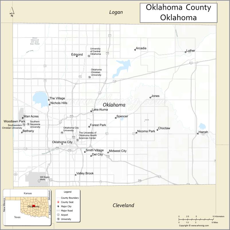
About Oklahoma County Map, Oklahoma: The map showing the county boundary, county seat, major cities, highways, water bodies and neighbouring counties.
Related Oklahoma Maps
About Oklahoma County, Oklahoma
Oklahoma County is a county located in the U.S. state of Oklahoma. It's county seat is Oklahoma City. As per 2020 census, the population of Oklahoma County is 798575 people and population density is 1126.34 square miles. According to the United States Census Bureau, the county has a total area of 709 sq mi (1,836 km2). Oklahoma County was established on 1891.
Oklahoma County Facts
| Continent | North America |
| Country | United States |
| State | Oklahoma |
| County Seat | Oklahoma City |
| Largest City/Town | Oklahoma City |
| Established | 1890 |
| Total Area | 718 sq mi (1,860 sq km) |
| Land Area | 709 sq mi (1,836 sq km) |
| Water Area | 9 sq mi (23 sq km) |
| Population | 796,292 (Census 2020) |
| Population Density | 1,123 people per sq mi |
| Time Zone | Central Time Zone (CST/CDT) |
| Major Highways | Interstate 35, Interstate 40, Interstate 44, Interstate 235, U.S. Route 66 |
| Major Rivers | North Canadian River, Deep Fork River |
| Neighboring Counties | Canadian County, Cleveland County, Logan County, Lincoln County, Pottawatomie County |
| Famous For | Oklahoma City, government centers, professional sports, museums, and major business districts |
| Top Attractions | Oklahoma City National Memorial, Bricktown, Oklahoma City Zoo, and Scissortail Park |
| Official Website | Official Website |
About Oklahoma County, Oklahoma
Oklahoma County is located in central Oklahoma and is home to Oklahoma City, the state capital and largest city. Established in 1890 during the Land Run era, the county serves as the political, economic, cultural, and transportation center of Oklahoma. The county is known for government institutions, sports venues, museums, entertainment districts, and rapidly growing suburban communities.
Cities and Towns in Oklahoma County, Oklahoma
| City/Town | Population (Census 2020) | Latitude & Longitude |
|---|---|---|
| Oklahoma City (county seat) | 681,054 | 35.4676°N, 97.5164°W |
| Edmond | 94,428 | 35.6528°N, 97.4781°W |
| Midwest City | 57,249 | 35.4495°N, 97.3967°W |
| Del City | 21,332 | 35.4420°N, 97.4409°W |
| Choctaw | 12,182 | 35.4976°N, 97.2689°W |
| Nichols Hills | 3,879 | 35.5509°N, 97.5489°W |
Golf Courses in Oklahoma County, Oklahoma
| Golf Course | Location | Latitude & Longitude |
|---|---|---|
| Lincoln Park Golf Course | Oklahoma City | 35.4956°N, 97.5014°W |
| Gaillardia Country Club | Oklahoma City | 35.6393°N, 97.6148°W |
| KickingBird Golf Club | Edmond | 35.6408°N, 97.4376°W |
Major Roads and Highways in Oklahoma County, Oklahoma
Oklahoma County contains one of the most important highway networks in the central United States, connecting Oklahoma City with regional and national destinations.
- Interstate 35 - major north-south interstate linking Texas and Kansas
- Interstate 40 - major east-west interstate connecting California and North Carolina
- Interstate 44 - transportation corridor connecting Oklahoma City, Tulsa, and Missouri
- Interstate 235 - urban interstate through central Oklahoma City
- Historic U.S. Route 66 - iconic highway passing through Oklahoma City
What are the Neighboring Counties of Oklahoma County
- Logan County (north)
- Lincoln County (east)
- Pottawatomie County (southeast)
- Cleveland County (south)
- Canadian County (west)
What are the Top Places to Visit in Oklahoma County, Oklahoma
The county offers museums, entertainment districts, parks, sports venues, and major cultural attractions.
- Oklahoma City National Memorial and Museum - memorial honoring the victims of the 1995 bombing
- Bricktown Entertainment District - restaurants, nightlife, canals, and entertainment venues
- Oklahoma City Zoo and Botanical Garden - wildlife exhibits and family attractions
- Scissortail Park - downtown urban park with trails, gardens, and recreation areas
- National Cowboy and Western Heritage Museum - western art and history exhibits
- Paycom Center - home arena for the Oklahoma City Thunder NBA team
- Myriad Botanical Gardens - indoor tropical conservatory and gardens
- Science Museum Oklahoma - interactive science and technology exhibits
- Lake Hefner Recreation Area - sailing, cycling, fishing, and waterfront dining
- Frontier City and Hurricane Harbor - amusement and water park attractions
What is the Distance from Oklahoma County to Nearby Cities
The following distances are measured by road (driving).
- Oklahoma City to Tulsa (Tulsa County), Oklahoma - 106 mi (171 km)
- Oklahoma City to Norman (Cleveland County), Oklahoma - 21 mi (34 km)
- Oklahoma City to Edmond (Oklahoma County), Oklahoma - 14 mi (23 km)
- Oklahoma City to Stillwater (Payne County), Oklahoma - 66 mi (106 km)
- Oklahoma City to Wichita Falls (Wichita County), Texas - 139 mi (224 km)
- Oklahoma City to Dallas (Dallas County), Texas - 206 mi (332 km)
- Oklahoma City to Amarillo (Potter County), Texas - 260 mi (418 km)
- Oklahoma City to Little Rock (Pulaski County), Arkansas - 347 mi (558 km)
- Oklahoma City to Kansas City (Jackson County), Missouri - 352 mi (566 km)
- Oklahoma City to Denver (Denver County), Colorado - 679 mi (1,093 km)
- Oklahoma City to Chicago (Cook County), Illinois - 792 mi (1,275 km)
- Oklahoma City to Atlanta (Fulton County), Georgia - 882 mi (1,419 km)
- Oklahoma City to Los Angeles (Los Angeles County), California - 1,332 mi (2,144 km)
FAQs about Oklahoma County
Oklahoma County is located in central Oklahoma and includes Oklahoma City, the state capital.
Oklahoma County had a population of 796,292 according to the 2020 United States Census.
Oklahoma County is known for Oklahoma City, government institutions, museums, sports, and entertainment districts.
The county is served by Interstate 35, Interstate 40, Interstate 44, Interstate 235, and historic U.S. Route 66.
Yes, Oklahoma County includes major golf facilities such as Lincoln Park Golf Course, Gaillardia Country Club, and KickingBird Golf Club.
References
- QuickFacts - U.S. Census Bureau
- United States Census Bureau
- United States Geological Survey (USGS)
- National Geodetic Survey
- Official Website
- Adair County Map
- Alfalfa County Map
- Atoka County Map
- Beaver County Map
- Beckham County Map
- Blaine County Map
- Bryan County Map
- Caddo County Map
- Canadian County Map
- Carter County Map
- Cherokee County Map
- Choctaw County Map
- Cimarron County Map
- Cleveland County Map
- Coal County Map
- Comanche County Map
- Cotton County Map
- Craig County Map
- Creek County Map
- Custer County Map
- Delaware County Map
- Dewey County Map
- Ellis County Map
- Garfield County Map
- Garvin County Map
- Grady County Map
- Grant County Map
- Greer County Map
- Harmon County Map
- Harper County Map
- Haskell County Map
- Hughes County Map
- Jackson County Map
- Jefferson County Map
- Johnston County Map
- Kay County Map
- Kingfisher County Map
- Kiowa County Map
- Latimer County Map
- Le Flore County Map
- Lincoln County Map
- Logan County Map
- Love County Map
- McClain County Map
- McCurtain County Map
- McIntosh County Map
- Major County Map
- Marshall County Map
- Mayes County Map
- Murray County Map
- Muskogee County Map
- Noble County Map
- Nowata County Map
- Okfuskee County Map
- Oklahoma County Map
- Okmulgee County Map
- Osage County Map
- Ottawa County Map
- Pawnee County Map
- Payne County Map
- Pittsburg County Map
- Pontotoc County Map
- Pottawatomie County Map
- Pushmataha County Map
- Roger Mills County Map
- Rogers County Map
- Seminole County Map
- Sequoyah County Map
- Stephens County Map
- Texas County Map
- Tillman County Map
- Tulsa County Map
- Wagoner County Map
- Washington County Map
- Washita County Map
- Woods County Map
- Woodward County Map
- Alabama Counties
- Alaska boroughs
- Arizona Counties
- Arkansas Counties
- California County Map
- Colorado Counties
- Connecticut Counties
- Delaware Counties
- Florida County Map
- Georgia County Map
- Hawaii Counties
- Idaho Counties
- Illinois Counties
- Indiana Counties
- Iowa Counties
- Kansas Counties
- Kentucky Counties
- Louisiana Counties
- Maine Counties
- Maryland Counties
- Massachusetts Counties
- Michigan County Map
- Minnesota Counties
- Mississippi Counties
- Missouri Counties
- Montana Counties
- Nebraska Counties
- Nevada Counties
- New York Counties
- New Hampshire Counties
- New Jersey Counties
- New Mexico Counties
- North Carolina Counties
- North Dakota Counties
- Ohio County Map
- Oklahoma Counties
- Oregon Counties
- Pennsylvania Counties
- Rhode Island Counties
- South Carolina Counties
- South Dakota Counties
- Map of Tennessee
- Texas County Map
- Utah Counties
- Vermont Counties
- Virginia Counties
- Washington Counties
- West Virginia Counties
- Wisconsin Counties
- Wyoming Counties