Written and Fact-checked by Whereig Editors, Reviewed by Mukesh Kumar| Updated On: May 15, 2026
Map of Wagoner County - Wagoner County is a county located in the U.S. state of Oklahoma. Wagoner County Map showing cities, highways, important places and water bodies. Get Where is Wagoner County located in the map, major cities in Wagoner county, population, areas, and places of interest.
Map of Wagoner County, Oklahoma
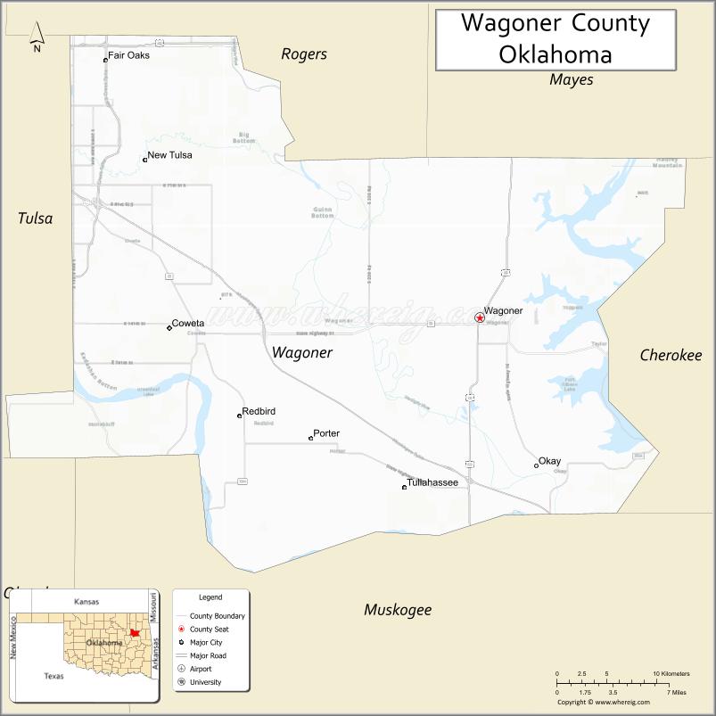
About Wagoner County Map, Oklahoma: The map showing the county boundary, county seat, major cities, highways, water bodies and neighbouring counties.
Related Oklahoma Maps
About Wagoner County, Oklahoma
Wagoner County is a county located in the U.S. state of Oklahoma. It's county seat is Wagoner. As per 2020 census, the population of Wagoner County is 84050 people and population density is 149.29 square miles. According to the United States Census Bureau, the county has a total area of 563 sq mi (1,458 km2). Wagoner County was established on 1907.
Wagoner County Facts
| Continent | North America |
| Country | United States |
| State | Oklahoma |
| County Seat | Wagoner |
| Largest City/Town | Broken Arrow (partly) |
| Established | 1907 |
| Total Area | 568 sq mi (1,471 sq km) |
| Land Area | 562 sq mi (1,456 sq km) |
| Water Area | 6 sq mi (16 sq km) |
| Population | 80,981 (Census 2020) |
| Population Density | 144.1 people per sq mi |
| Time Zone | Central Time Zone |
| Major Highways | U.S. Highway 69, State Highway 51, State Highway 16, State Highway 72, Muskogee Turnpike |
| Major Rivers | Arkansas River, Verdigris River, Neosho River |
| Neighboring Counties | Rogers County, Mayes County, Cherokee County, Muskogee County, Tulsa County |
| Famous For | Fort Gibson Lake, outdoor recreation, boating, fishing, and growing Tulsa suburbs |
| Top Attractions | Fort Gibson Lake, Sequoyah State Park, Three Forks Harbor, and historic downtown Wagoner |
| Official Website | Official Website |
About Wagoner County, Oklahoma
Wagoner County is located in northeastern Oklahoma and was established in 1907. The county seat is Wagoner, while Broken Arrow is the county’s largest community by population. The county is known for its lakes, rivers, wooded hills, and strong connection to outdoor recreation in the Tulsa metropolitan region.
Cities and Towns in Wagoner County, Oklahoma
| City/Town | Population (Census 2020) | Latitude & Longitude |
|---|---|---|
| Wagoner (county seat) | 8,610 | 35.9595°N, 95.3697°W |
| Broken Arrow (partly) | 113,540 | 36.0526°N, 95.7908°W |
| Coweta | 9,943 | 35.9515°N, 95.6508°W |
| Porter | 602 | 35.8734°N, 95.5225°W |
| Redbird | 5 | 35.8415°N, 95.5869°W |
| Tullahassee | 104 | 35.8406°N, 95.4225°W |
| Okay | 621 | 35.8506°N, 95.3200°W |
| Oktaha | 390 | 35.5770°N, 95.4755°W |
| Fort Gibson | 3,981 | 35.7987°N, 95.2508°W |
| Hulbert | 500 | 35.9326°N, 95.1419°W |
| Taft | 174 | 35.7690°N, 95.5450°W |
| Wagoner (CDP) | Unincorporated areas | 35.9595°N, 95.3697°W |
Golf Courses in Wagoner County, Oklahoma
| Golf Course | Location | Latitude & Longitude |
|---|---|---|
| Cherokee Hills Golf Club | Catoosa | 36.1787°N, 95.7278°W |
| Indian Springs Country Club | Broken Arrow | 36.0112°N, 95.7579°W |
| The Club at Forest Ridge | Broken Arrow | 36.0459°N, 95.6992°W |
| Wagoner Golf Club | Wagoner | 35.9555°N, 95.3918°W |
| Emerald Falls Golf Course | Broken Arrow | 36.0215°N, 95.7104°W |
Major Roads and Highways in Wagoner County, Oklahoma
Major highways connect the county to nearby regions and cities.
- U.S. Highway 69 - north-south route connecting Wagoner with Muskogee and Pryor
- State Highway 51 - major east-west highway linking Broken Arrow, Coweta, and Wagoner
- State Highway 16 - connects Wagoner County with Rogers and Muskogee counties
- State Highway 72 - serves rural communities and lake areas
- Muskogee Turnpike - toll highway connecting Tulsa with Muskogee
What are the Neighboring Counties of Wagoner County
- Rogers County (north)
- Mayes County (northeast)
- Cherokee County (east)
- Muskogee County (south)
- Tulsa County (west)
What are the Top Places to Visit in Wagoner County, Oklahoma
The county offers a mix of natural and cultural attractions.
- Fort Gibson Lake - large reservoir known for boating, fishing, and camping
- Sequoyah State Park - scenic park with trails, golf, marina, and lake recreation
- Three Forks Harbor - river port and recreational waterfront area near Muskogee
- Fort Gibson Historic Site - preserved military fort with museums and historic buildings
- Wagoner City Park - local recreation area with playgrounds and sports facilities
- Blue Bell Creameries Country Store - popular regional attraction near Broken Arrow
- Coweta Historical Museum - exhibits focused on local and Native American history
- Verdigris River Area - fishing and boating access points throughout the county
- Ray Harral Nature Park - walking trails and wooded outdoor recreation area
- Bass Pro Shops Outdoor World - major outdoor retail and entertainment destination
What is the Distance from Wagoner County to Nearby Cities
The following distances are measured by road (driving).
- Wagoner to Tulsa (Tulsa County), Oklahoma - 38 mi (61 km)
- Wagoner to Muskogee (Muskogee County), Oklahoma - 18 mi (29 km)
- Wagoner to Broken Arrow (Tulsa County), Oklahoma - 24 mi (39 km)
- Wagoner to Owasso (Tulsa County), Oklahoma - 40 mi (64 km)
- Wagoner to Claremore (Rogers County), Oklahoma - 36 mi (58 km)
- Wagoner to Tahlequah (Cherokee County), Oklahoma - 41 mi (66 km)
- Wagoner to Pryor Creek (Mayes County), Oklahoma - 39 mi (63 km)
- Wagoner to Oklahoma City (Oklahoma County), Oklahoma - 150 mi (241 km)
- Wagoner to McAlester (Pittsburg County), Oklahoma - 101 mi (163 km)
- Wagoner to Joplin (Jasper County), Missouri - 112 mi (180 km)
- Wagoner to Fort Smith (Sebastian County), Arkansas - 101 mi (163 km)
- Wagoner to Fayetteville (Washington County), Arkansas - 108 mi (174 km)
FAQs about Wagoner County
Wagoner County is located in northeastern Oklahoma and is part of the Tulsa metropolitan region.
The population of Wagoner County was 80,981 according to the Census 2020.
Wagoner County is known for Fort Gibson Lake, boating, fishing, outdoor recreation, and growing suburban communities.
The county is served by U.S. Highway 69, State Highway 51, State Highway 16, State Highway 72, and the Muskogee Turnpike.
Yes, Wagoner County has several golf courses including Wagoner Golf Club and Forest Ridge Golf Club.
References
- QuickFacts - U.S. Census Bureau
- United States Census Bureau
- United States Geological Survey (USGS)
- National Geodetic Survey
- Official County Website
- Adair County Map
- Alfalfa County Map
- Atoka County Map
- Beaver County Map
- Beckham County Map
- Blaine County Map
- Bryan County Map
- Caddo County Map
- Canadian County Map
- Carter County Map
- Cherokee County Map
- Choctaw County Map
- Cimarron County Map
- Cleveland County Map
- Coal County Map
- Comanche County Map
- Cotton County Map
- Craig County Map
- Creek County Map
- Custer County Map
- Delaware County Map
- Dewey County Map
- Ellis County Map
- Garfield County Map
- Garvin County Map
- Grady County Map
- Grant County Map
- Greer County Map
- Harmon County Map
- Harper County Map
- Haskell County Map
- Hughes County Map
- Jackson County Map
- Jefferson County Map
- Johnston County Map
- Kay County Map
- Kingfisher County Map
- Kiowa County Map
- Latimer County Map
- Le Flore County Map
- Lincoln County Map
- Logan County Map
- Love County Map
- McClain County Map
- McCurtain County Map
- McIntosh County Map
- Major County Map
- Marshall County Map
- Mayes County Map
- Murray County Map
- Muskogee County Map
- Noble County Map
- Nowata County Map
- Okfuskee County Map
- Oklahoma County Map
- Okmulgee County Map
- Osage County Map
- Ottawa County Map
- Pawnee County Map
- Payne County Map
- Pittsburg County Map
- Pontotoc County Map
- Pottawatomie County Map
- Pushmataha County Map
- Roger Mills County Map
- Rogers County Map
- Seminole County Map
- Sequoyah County Map
- Stephens County Map
- Texas County Map
- Tillman County Map
- Tulsa County Map
- Wagoner County Map
- Washington County Map
- Washita County Map
- Woods County Map
- Woodward County Map
- Alabama Counties
- Alaska boroughs
- Arizona Counties
- Arkansas Counties
- California County Map
- Colorado Counties
- Connecticut Counties
- Delaware Counties
- Florida County Map
- Georgia County Map
- Hawaii Counties
- Idaho Counties
- Illinois Counties
- Indiana Counties
- Iowa Counties
- Kansas Counties
- Kentucky Counties
- Louisiana Counties
- Maine Counties
- Maryland Counties
- Massachusetts Counties
- Michigan County Map
- Minnesota Counties
- Mississippi Counties
- Missouri Counties
- Montana Counties
- Nebraska Counties
- Nevada Counties
- New York Counties
- New Hampshire Counties
- New Jersey Counties
- New Mexico Counties
- North Carolina Counties
- North Dakota Counties
- Ohio County Map
- Oklahoma Counties
- Oregon Counties
- Pennsylvania Counties
- Rhode Island Counties
- South Carolina Counties
- South Dakota Counties
- Map of Tennessee
- Texas County Map
- Utah Counties
- Vermont Counties
- Virginia Counties
- Washington Counties
- West Virginia Counties
- Wisconsin Counties
- Wyoming Counties