Written and Fact-checked by Whereig Editors, Reviewed by Mukesh Kumar| Updated On: May 15, 2026
Map of Alfalfa County - Alfalfa County is a county located in the U.S. state of Oklahoma. Alfalfa County Map showing cities, highways, important places and water bodies. Get Where is Alfalfa County located in the map, major cities in Alfalfa county, population, areas, and places of interest.
Map of Alfalfa County, Oklahoma
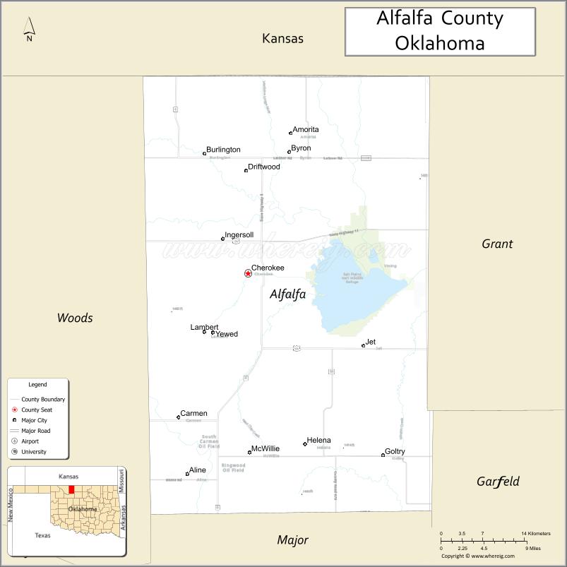
About Alfalfa County Map, Oklahoma: The map showing the county boundary, county seat, major cities, highways, water bodies and neighbouring counties.
Related Oklahoma Maps
About Alfalfa County, Oklahoma
Alfalfa County is a county located in the U.S. state of Oklahoma. It's county seat is Cherokee. As per 2020 census, the population of Alfalfa County is 5710 people and population density is 6.59 square miles. According to the United States Census Bureau, the county has a total area of 867 sq mi (2,246 km2). Alfalfa County was established on 1907.
Alfalfa County Facts
| Continent | North America |
| Country | United States |
| State | Oklahoma |
| County Seat | Cherokee |
| Largest City/Town | Cherokee |
| Established | 1907 |
| Total Area | 881 sq mi (2,282 sq km) |
| Land Area | 866 sq mi (2,243 sq km) |
| Water Area | 15 sq mi (39 sq km) |
| Population | 5,699 (Census 2020) |
| Population Density | 6.6 people per sq mi |
| Time Zone | Central Time Zone (CST/CDT) |
| Major Highways | U.S. Route 64, U.S. Route 281, Oklahoma State Highway 8 |
| Major Rivers | Salt Fork Arkansas River, Great Salt Plains Lake nearby region |
| Neighboring Counties | Woods County, Grant County, Major County, Barber County (Kansas), Harper County |
| Famous For | Wheat farming, Great Salt Plains nearby region, birdwatching, and prairie landscapes |
| Top Attractions | Great Salt Plains State Park nearby region, Salt Plains National Wildlife Refuge, Cherokee Strip Museum, and prairie scenic drives |
| Official Website | Official Website |
About Alfalfa County, Oklahoma
Alfalfa County is located in northwestern Oklahoma near the Kansas border and was established in 1907. The county seat and largest town is Cherokee. The county is known for agriculture, wide-open prairie landscapes, wildlife refuges, salt plains recreation, and bird migration habitats.
Cities and Towns in Alfalfa County, Oklahoma
| City/Town | Population (Census 2020) | Latitude & Longitude |
|---|---|---|
| Cherokee (county seat) | 1,051 | 36.7545°N, 98.3567°W |
| Jet | 197 | 36.6670°N, 98.1789°W |
| Burlington | 133 | 36.9003°N, 98.4223°W |
| Aline | 185 | 36.5070°N, 98.4484°W |
| Carmen | 355 | 36.5782°N, 98.4767°W |
| Goltry | 249 | 36.5303°N, 98.1531°W |
Golf Courses in Alfalfa County, Oklahoma
| Golf Course | Location | Latitude & Longitude |
|---|---|---|
| Cherokee Municipal Golf Course | Cherokee | 36.7622°N, 98.3698°W |
| Salt Plains Recreation Golf Area | Jet nearby region | 36.6758°N, 98.1927°W |
| Prairie Winds Golf Area | Carmen nearby region | 36.5891°N, 98.4874°W |
Major Roads and Highways in Alfalfa County, Oklahoma
Major highways connect Alfalfa County with northwestern Oklahoma, Kansas, and regional agricultural communities.
- U.S. Route 64 - major east-west transportation corridor across northern Oklahoma
- U.S. Route 281 - important north-south route connecting Oklahoma and Kansas
- Oklahoma State Highway 8 - regional highway serving rural prairie communities
What are the Neighboring Counties of Alfalfa County
- Barber County, Kansas (north)
- Woods County (west)
- Harper County (northwest)
- Grant County (east)
- Major County (south)
What are the Top Places to Visit in Alfalfa County, Oklahoma
The county offers prairie scenery, wildlife refuges, lakes, and outdoor recreation opportunities.
- Great Salt Plains State Park nearby region - camping, boating, fishing, and hiking recreation
- Salt Plains National Wildlife Refuge - birdwatching and migratory wildlife habitat
- Great Salt Plains Lake nearby region - swimming, kayaking, and fishing activities
- Cherokee Strip Museum - local history and pioneer heritage exhibits
- Prairie Scenic Drives - open plains and countryside photography opportunities
- Crystal Digging Areas nearby region - unique selenite crystal digging attraction
- Community Festivals and Agricultural Events - local traditions and seasonal celebrations
- Hunting Areas and Wildlife Observation - deer hunting and birdwatching opportunities
- Historic Downtown Cherokee - local shops and community businesses
- Parks and Picnic Areas - family recreation and outdoor relaxation
What is the Distance from Alfalfa County to Nearby Cities
The following distances are measured by road (driving).
- Cherokee to Enid (Garfield County), Oklahoma - 52 mi (84 km)
- Cherokee to Alva (Woods County), Oklahoma - 29 mi (47 km)
- Cherokee to Wichita (Sedgwick County), Kansas - 134 mi (216 km)
- Cherokee to Oklahoma City (Oklahoma County), Oklahoma - 153 mi (246 km)
- Cherokee to Carmen (Alfalfa County), Oklahoma - 13 mi (21 km)
- Cherokee to Jet (Alfalfa County), Oklahoma - 15 mi (24 km)
- Cherokee to Tulsa (Tulsa County), Oklahoma - 192 mi (309 km)
- Cherokee to Amarillo (Potter County), Texas - 208 mi (335 km)
- Cherokee to Kansas City (Jackson County), Missouri - 319 mi (513 km)
- Cherokee to Dallas (Dallas County), Texas - 360 mi (579 km)
- Cherokee to Denver (Denver County), Colorado - 430 mi (692 km)
- Cherokee to Albuquerque (Bernalillo County), New Mexico - 502 mi (808 km)
- Cherokee to Chicago (Cook County), Illinois - 699 mi (1,125 km)
FAQs about Alfalfa County
Alfalfa County is located in northwestern Oklahoma near the Kansas border.
Alfalfa County had a population of 5,699 according to the 2020 United States Census.
Alfalfa County is known for wheat farming, prairie landscapes, and the Great Salt Plains recreation region.
The county is served by U.S. Route 64, U.S. Route 281, and Oklahoma State Highway 8.
Yes, Alfalfa County includes golf and recreation facilities near Cherokee and surrounding prairie communities.
References
- QuickFacts - U.S. Census Bureau
- United States Census Bureau
- United States Geological Survey (USGS)
- National Geodetic Survey
- Official Website
- Adair County Map
- Alfalfa County Map
- Atoka County Map
- Beaver County Map
- Beckham County Map
- Blaine County Map
- Bryan County Map
- Caddo County Map
- Canadian County Map
- Carter County Map
- Cherokee County Map
- Choctaw County Map
- Cimarron County Map
- Cleveland County Map
- Coal County Map
- Comanche County Map
- Cotton County Map
- Craig County Map
- Creek County Map
- Custer County Map
- Delaware County Map
- Dewey County Map
- Ellis County Map
- Garfield County Map
- Garvin County Map
- Grady County Map
- Grant County Map
- Greer County Map
- Harmon County Map
- Harper County Map
- Haskell County Map
- Hughes County Map
- Jackson County Map
- Jefferson County Map
- Johnston County Map
- Kay County Map
- Kingfisher County Map
- Kiowa County Map
- Latimer County Map
- Le Flore County Map
- Lincoln County Map
- Logan County Map
- Love County Map
- McClain County Map
- McCurtain County Map
- McIntosh County Map
- Major County Map
- Marshall County Map
- Mayes County Map
- Murray County Map
- Muskogee County Map
- Noble County Map
- Nowata County Map
- Okfuskee County Map
- Oklahoma County Map
- Okmulgee County Map
- Osage County Map
- Ottawa County Map
- Pawnee County Map
- Payne County Map
- Pittsburg County Map
- Pontotoc County Map
- Pottawatomie County Map
- Pushmataha County Map
- Roger Mills County Map
- Rogers County Map
- Seminole County Map
- Sequoyah County Map
- Stephens County Map
- Texas County Map
- Tillman County Map
- Tulsa County Map
- Wagoner County Map
- Washington County Map
- Washita County Map
- Woods County Map
- Woodward County Map
- Alabama Counties
- Alaska boroughs
- Arizona Counties
- Arkansas Counties
- California County Map
- Colorado Counties
- Connecticut Counties
- Delaware Counties
- Florida County Map
- Georgia County Map
- Hawaii Counties
- Idaho Counties
- Illinois Counties
- Indiana Counties
- Iowa Counties
- Kansas Counties
- Kentucky Counties
- Louisiana Counties
- Maine Counties
- Maryland Counties
- Massachusetts Counties
- Michigan County Map
- Minnesota Counties
- Mississippi Counties
- Missouri Counties
- Montana Counties
- Nebraska Counties
- Nevada Counties
- New York Counties
- New Hampshire Counties
- New Jersey Counties
- New Mexico Counties
- North Carolina Counties
- North Dakota Counties
- Ohio County Map
- Oklahoma Counties
- Oregon Counties
- Pennsylvania Counties
- Rhode Island Counties
- South Carolina Counties
- South Dakota Counties
- Map of Tennessee
- Texas County Map
- Utah Counties
- Vermont Counties
- Virginia Counties
- Washington Counties
- West Virginia Counties
- Wisconsin Counties
- Wyoming Counties