Written and Fact-checked by Whereig Editors, Reviewed by Mukesh Kumar| Updated On: May 15, 2026
Map of Cherokee County - Cherokee County is a county located in the U.S. state of Oklahoma. Cherokee County Map showing cities, highways, important places and water bodies. Get Where is Cherokee County located in the map, major cities in Cherokee county, population, areas, and places of interest.
Map of Cherokee County, Oklahoma
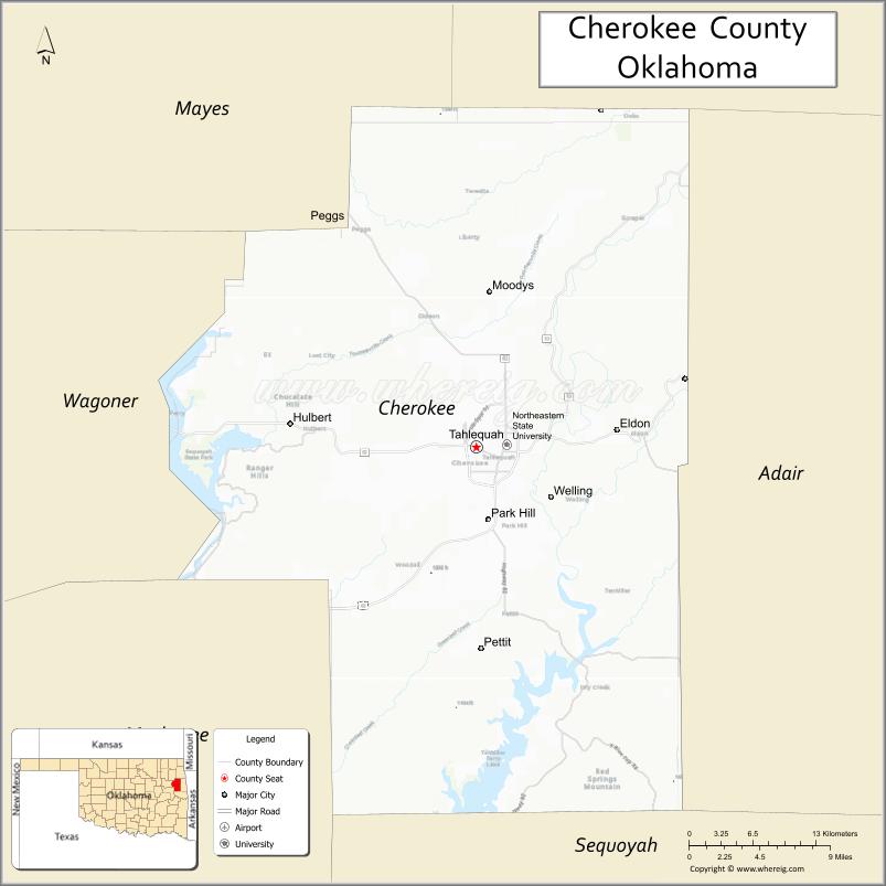
About Cherokee County Map, Oklahoma: The map showing the county boundary, county seat, major cities, highways, water bodies and neighbouring counties.
Related Oklahoma Maps
About Cherokee County, Oklahoma
Cherokee County is a county located in the U.S. state of Oklahoma. It's county seat is Tahlequah. As per 2020 census, the population of Cherokee County is 47627 people and population density is 63.42 square miles. According to the United States Census Bureau, the county has a total area of 751 sq mi (1,945 km2). Cherokee County was established on 1907.
Cherokee County Facts
| Continent | North America |
| Country | United States |
| State | Oklahoma |
| County Seat | Tahlequah |
| Largest City/Town | Tahlequah |
| Established | 1907 |
| Total Area | 776 sq mi (2,010 sq km) |
| Land Area | 749 sq mi (1,940 sq km) |
| Water Area | 27 sq mi (70 sq km) |
| Population | 48,184 (Census 2020) |
| Population Density | 64.3 people per sq mi |
| Time Zone | Central Time Zone (CST/CDT) |
| Major Highways | U.S. Route 62, State Highway 51, State Highway 82 |
| Major Rivers | Illinois River, Grand River nearby region, Tenkiller Ferry Lake nearby region |
| Neighboring Counties | Adair County, Delaware County, Sequoyah County, Wagoner County, Muskogee County, Mayes County |
| Famous For | Cherokee Nation capital, Illinois River recreation, Tahlequah, and Native American heritage |
| Top Attractions | Cherokee Heritage Center, Illinois River recreation, Tenkiller State Park nearby region, and Northeastern State University |
| Official Website | Official Website |
About Cherokee County, Oklahoma
Cherokee County is located in eastern Oklahoma within the scenic Cookson Hills region and was established in 1907 from former Cherokee Nation territory. The county seat and largest city is Tahlequah, which also serves as the capital of the Cherokee Nation. The county is known for rivers, lakes, forests, Cherokee culture, and higher education.
Cities and Towns in Cherokee County, Oklahoma
| City/Town | Population (Census 2020) | Latitude & Longitude |
|---|---|---|
| Tahlequah (county seat) | 16,209 | 35.9154°N, 94.9699°W |
| Fort Gibson | 3,981 | 35.7976°N, 95.2505°W |
| Park Hill | 3,709 | 35.8615°N, 94.9583°W |
| Keys | 1,030 | 35.8012°N, 95.0138°W |
| Hulbert | 590 | 35.9320°N, 95.1428°W |
| Cookson nearby region | 506 | 35.7118°N, 94.9030°W |
Golf Courses in Cherokee County, Oklahoma
| Golf Course | Location | Latitude & Longitude |
|---|---|---|
| Cherokee Springs Golf Club | Tahlequah | 35.9286°N, 94.9837°W |
| Tenkiller Golf Club | Cookson nearby region | 35.7249°N, 94.9186°W |
| Fort Gibson Recreation Golf Area | Fort Gibson | 35.8091°N, 95.2624°W |
Major Roads and Highways in Cherokee County, Oklahoma
Major highways connect Cherokee County with eastern Oklahoma, Tulsa, and regional Cherokee Nation communities.
- U.S. Route 62 - major east-west transportation corridor across eastern Oklahoma
- State Highway 51 - important route linking Tahlequah with Tulsa and western Oklahoma
- State Highway 82 - scenic highway serving lake and recreation regions
What are the Neighboring Counties of Cherokee County
- Delaware County (north)
- Mayes County (northwest)
- Wagoner County (west)
- Muskogee County (southwest)
- Sequoyah County (south)
- Adair County (east)
What are the Top Places to Visit in Cherokee County, Oklahoma
The county offers Cherokee heritage attractions, rivers, lakes, forests, and outdoor recreation opportunities.
- Cherokee Heritage Center - Native American history, cultural exhibits, and historic village
- Illinois River Recreation Areas - floating, kayaking, fishing, and camping activities
- Tenkiller State Park nearby region - boating, hiking, scuba diving, and lakeside recreation
- Northeastern State University - historic university campus and cultural events
- Cherokee Nation Capitol nearby region - tribal government and heritage landmark
- Cookson Hills Scenic Drives - forests and mountain photography opportunities
- Fort Gibson Lake nearby region - fishing, boating, and camping recreation
- Historic Downtown Tahlequah - shops, museums, restaurants, and community events
- Community Festivals and Cherokee Cultural Events - traditional performances and celebrations
- Nature Trails and Wildlife Areas - hiking and environmental exploration
What is the Distance from Cherokee County to Nearby Cities
The following distances are measured by road (driving).
- Tahlequah to Tulsa (Tulsa County), Oklahoma - 71 mi (114 km)
- Tahlequah to Muskogee (Muskogee County), Oklahoma - 41 mi (66 km)
- Tahlequah to Fayetteville (Washington County), Arkansas - 73 mi (117 km)
- Tahlequah to Fort Smith (Sebastian County), Arkansas - 68 mi (109 km)
- Tahlequah to Fort Gibson (Cherokee County), Oklahoma - 20 mi (32 km)
- Tahlequah to Hulbert (Cherokee County), Oklahoma - 12 mi (19 km)
- Tahlequah to Oklahoma City (Oklahoma County), Oklahoma - 172 mi (277 km)
- Tahlequah to Joplin (Jasper County), Missouri - 112 mi (180 km)
- Tahlequah to Kansas City (Jackson County), Missouri - 256 mi (412 km)
- Tahlequah to Dallas (Dallas County), Texas - 281 mi (452 km)
- Tahlequah to Little Rock (Pulaski County), Arkansas - 214 mi (344 km)
- Tahlequah to Denver (Denver County), Colorado - 694 mi (1,117 km)
- Tahlequah to Chicago (Cook County), Illinois - 598 mi (962 km)
FAQs about Cherokee County
Cherokee County is located in eastern Oklahoma within the Cookson Hills region.
Cherokee County had a population of 48,184 according to the 2020 United States Census.
Cherokee County is known for the Cherokee Nation capital, Illinois River recreation, and Native American heritage.
The county is served by U.S. Route 62, State Highway 51, and State Highway 82.
Yes, Cherokee County includes golf facilities such as Cherokee Springs Golf Club and Tenkiller Golf Club.
References
- QuickFacts - U.S. Census Bureau
- United States Census Bureau
- United States Geological Survey (USGS)
- National Geodetic Survey
- Official Website
- Adair County Map
- Alfalfa County Map
- Atoka County Map
- Beaver County Map
- Beckham County Map
- Blaine County Map
- Bryan County Map
- Caddo County Map
- Canadian County Map
- Carter County Map
- Cherokee County Map
- Choctaw County Map
- Cimarron County Map
- Cleveland County Map
- Coal County Map
- Comanche County Map
- Cotton County Map
- Craig County Map
- Creek County Map
- Custer County Map
- Delaware County Map
- Dewey County Map
- Ellis County Map
- Garfield County Map
- Garvin County Map
- Grady County Map
- Grant County Map
- Greer County Map
- Harmon County Map
- Harper County Map
- Haskell County Map
- Hughes County Map
- Jackson County Map
- Jefferson County Map
- Johnston County Map
- Kay County Map
- Kingfisher County Map
- Kiowa County Map
- Latimer County Map
- Le Flore County Map
- Lincoln County Map
- Logan County Map
- Love County Map
- McClain County Map
- McCurtain County Map
- McIntosh County Map
- Major County Map
- Marshall County Map
- Mayes County Map
- Murray County Map
- Muskogee County Map
- Noble County Map
- Nowata County Map
- Okfuskee County Map
- Oklahoma County Map
- Okmulgee County Map
- Osage County Map
- Ottawa County Map
- Pawnee County Map
- Payne County Map
- Pittsburg County Map
- Pontotoc County Map
- Pottawatomie County Map
- Pushmataha County Map
- Roger Mills County Map
- Rogers County Map
- Seminole County Map
- Sequoyah County Map
- Stephens County Map
- Texas County Map
- Tillman County Map
- Tulsa County Map
- Wagoner County Map
- Washington County Map
- Washita County Map
- Woods County Map
- Woodward County Map
- Alabama Counties
- Alaska boroughs
- Arizona Counties
- Arkansas Counties
- California County Map
- Colorado Counties
- Connecticut Counties
- Delaware Counties
- Florida County Map
- Georgia County Map
- Hawaii Counties
- Idaho Counties
- Illinois Counties
- Indiana Counties
- Iowa Counties
- Kansas Counties
- Kentucky Counties
- Louisiana Counties
- Maine Counties
- Maryland Counties
- Massachusetts Counties
- Michigan County Map
- Minnesota Counties
- Mississippi Counties
- Missouri Counties
- Montana Counties
- Nebraska Counties
- Nevada Counties
- New York Counties
- New Hampshire Counties
- New Jersey Counties
- New Mexico Counties
- North Carolina Counties
- North Dakota Counties
- Ohio County Map
- Oklahoma Counties
- Oregon Counties
- Pennsylvania Counties
- Rhode Island Counties
- South Carolina Counties
- South Dakota Counties
- Map of Tennessee
- Texas County Map
- Utah Counties
- Vermont Counties
- Virginia Counties
- Washington Counties
- West Virginia Counties
- Wisconsin Counties
- Wyoming Counties