Written and Fact-checked by Whereig Editors, Reviewed by Mukesh Kumar| Updated On: May 15, 2026
Map of Cleveland County - Cleveland County is a county located in the U.S. state of Oklahoma. Cleveland County Map showing cities, highways, important places and water bodies. Get Where is Cleveland County located in the map, major cities in Cleveland county, population, areas, and places of interest.
Map of Cleveland County, Oklahoma
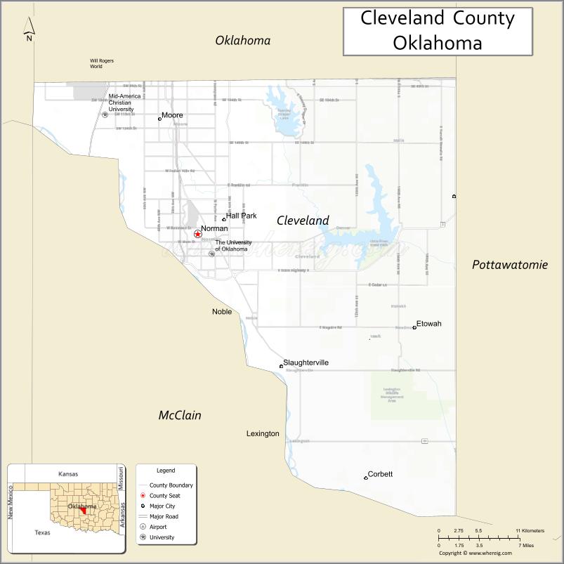
About Cleveland County Map, Oklahoma: The map showing the county boundary, county seat, major cities, highways, water bodies and neighbouring counties.
Related Oklahoma Maps
About Cleveland County, Oklahoma
Cleveland County is a county located in the U.S. state of Oklahoma. It's county seat is Norman. As per 2020 census, the population of Cleveland County is 297597 people and population density is 555.22 square miles. According to the United States Census Bureau, the county has a total area of 536 sq mi (1,388 km2). Cleveland County was established on 1890.
Cleveland County Facts
| Continent | North America |
| Country | United States |
| State | Oklahoma |
| County Seat | Norman |
| Largest City/Town | Norman |
| Established | 1890 |
| Total Area | 558 sq mi (1,445 sq km) |
| Land Area | 539 sq mi (1,396 sq km) |
| Water Area | 19 sq mi (49 sq km) |
| Population | 295,528 (Census 2020) |
| Population Density | 548.3 people per sq mi |
| Time Zone | Central Time Zone (CST/CDT) |
| Major Highways | Interstate 35, State Highway 9, U.S. Route 77 |
| Major Rivers | Canadian River, Little River, Lake Thunderbird nearby region |
| Neighboring Counties | Oklahoma County, McClain County, Pottawatomie County, Garvin County |
| Famous For | University of Oklahoma, Norman, college sports, research centers, and Lake Thunderbird |
| Top Attractions | University of Oklahoma, Sam Noble Museum, Lake Thunderbird State Park, and Gaylord Family Oklahoma Memorial Stadium |
| Official Website | Official Website |
About Cleveland County, Oklahoma
Cleveland County is located in central Oklahoma south of Oklahoma City and was established during the Oklahoma Territory era in 1890. The county seat and largest city is Norman, home to the University of Oklahoma. The county is known for higher education, research, sports, suburban growth, and outdoor recreation.
Cities and Towns in Cleveland County, Oklahoma
| City/Town | Population (Census 2020) | Latitude & Longitude |
|---|---|---|
| Norman (county seat) | 128,026 | 35.2226°N, 97.4395°W |
| Moore | 62,793 | 35.3395°N, 97.4867°W |
| Noble | 6,700 | 35.1390°N, 97.3945°W |
| Lexington | 2,152 | 35.0148°N, 97.3359°W |
| Slaughterville | 4,217 | 35.0884°N, 97.3350°W |
| Goldsby | 2,184 | 35.1417°N, 97.4761°W |
Golf Courses in Cleveland County, Oklahoma
| Golf Course | Location | Latitude & Longitude |
|---|---|---|
| Jimmie Austin OU Golf Club | Norman | 35.2158°N, 97.4452°W |
| Westwood Golf Course | Norman | 35.2281°N, 97.4566°W |
| Belmar Golf Club | Moore nearby region | 35.3478°N, 97.5059°W |
Major Roads and Highways in Cleveland County, Oklahoma
Major highways connect Cleveland County with Oklahoma City, southern Oklahoma, and regional university communities.
- Interstate 35 - major north-south interstate connecting Oklahoma and Texas
- State Highway 9 - east-west transportation corridor serving Norman and Lake Thunderbird
- U.S. Route 77 - regional highway linking communities through central Oklahoma
What are the Neighboring Counties of Cleveland County
- Oklahoma County (north)
- Pottawatomie County (east)
- McClain County (west)
- Garvin County (south)
What are the Top Places to Visit in Cleveland County, Oklahoma
The county offers university attractions, museums, sports venues, parks, and outdoor recreation.
- University of Oklahoma - major university campus with museums, athletics, and research centers
- Gaylord Family Oklahoma Memorial Stadium - home of Oklahoma Sooners football
- Sam Noble Oklahoma Museum of Natural History - exhibits on fossils, wildlife, and Native American history
- Lake Thunderbird State Park - boating, hiking, fishing, camping, and recreation
- Fred Jones Jr. Museum of Art - art collections and cultural exhibitions
- Historic Downtown Norman - restaurants, music venues, and shopping districts
- Riverwind Casino nearby region - entertainment, gaming, and concerts
- Parks and Nature Trails - family recreation and outdoor fitness activities
- Community Festivals and University Events - sports, music, and seasonal celebrations
- Canadian River Scenic Areas - wildlife observation and photography opportunities
What is the Distance from Cleveland County to Nearby Cities
The following distances are measured by road (driving).
- Norman to Oklahoma City (Oklahoma County), Oklahoma - 20 mi (32 km)
- Norman to Stillwater (Payne County), Oklahoma - 76 mi (122 km)
- Norman to Lawton (Comanche County), Oklahoma - 84 mi (135 km)
- Norman to Ardmore (Carter County), Oklahoma - 95 mi (153 km)
- Norman to Moore (Cleveland County), Oklahoma - 10 mi (16 km)
- Norman to Noble (Cleveland County), Oklahoma - 7 mi (11 km)
- Norman to Tulsa (Tulsa County), Oklahoma - 117 mi (188 km)
- Norman to Dallas (Dallas County), Texas - 190 mi (306 km)
- Norman to Wichita (Sedgwick County), Kansas - 176 mi (283 km)
- Norman to Amarillo (Potter County), Texas - 263 mi (423 km)
- Norman to Kansas City (Jackson County), Missouri - 347 mi (558 km)
- Norman to Denver (Denver County), Colorado - 685 mi (1,102 km)
- Norman to Chicago (Cook County), Illinois - 803 mi (1,292 km)
FAQs about Cleveland County
Cleveland County is located in central Oklahoma south of Oklahoma City.
Cleveland County had a population of 295,528 according to the 2020 United States Census.
Cleveland County is known for the University of Oklahoma, college sports, Norman, and Lake Thunderbird recreation.
The county is served by Interstate 35, State Highway 9, and U.S. Route 77.
Yes, Cleveland County includes golf facilities such as Jimmie Austin OU Golf Club and Westwood Golf Course.
References
- QuickFacts - U.S. Census Bureau
- United States Census Bureau
- United States Geological Survey (USGS)
- National Geodetic Survey
- Official Website
- Adair County Map
- Alfalfa County Map
- Atoka County Map
- Beaver County Map
- Beckham County Map
- Blaine County Map
- Bryan County Map
- Caddo County Map
- Canadian County Map
- Carter County Map
- Cherokee County Map
- Choctaw County Map
- Cimarron County Map
- Cleveland County Map
- Coal County Map
- Comanche County Map
- Cotton County Map
- Craig County Map
- Creek County Map
- Custer County Map
- Delaware County Map
- Dewey County Map
- Ellis County Map
- Garfield County Map
- Garvin County Map
- Grady County Map
- Grant County Map
- Greer County Map
- Harmon County Map
- Harper County Map
- Haskell County Map
- Hughes County Map
- Jackson County Map
- Jefferson County Map
- Johnston County Map
- Kay County Map
- Kingfisher County Map
- Kiowa County Map
- Latimer County Map
- Le Flore County Map
- Lincoln County Map
- Logan County Map
- Love County Map
- McClain County Map
- McCurtain County Map
- McIntosh County Map
- Major County Map
- Marshall County Map
- Mayes County Map
- Murray County Map
- Muskogee County Map
- Noble County Map
- Nowata County Map
- Okfuskee County Map
- Oklahoma County Map
- Okmulgee County Map
- Osage County Map
- Ottawa County Map
- Pawnee County Map
- Payne County Map
- Pittsburg County Map
- Pontotoc County Map
- Pottawatomie County Map
- Pushmataha County Map
- Roger Mills County Map
- Rogers County Map
- Seminole County Map
- Sequoyah County Map
- Stephens County Map
- Texas County Map
- Tillman County Map
- Tulsa County Map
- Wagoner County Map
- Washington County Map
- Washita County Map
- Woods County Map
- Woodward County Map
- Alabama Counties
- Alaska boroughs
- Arizona Counties
- Arkansas Counties
- California County Map
- Colorado Counties
- Connecticut Counties
- Delaware Counties
- Florida County Map
- Georgia County Map
- Hawaii Counties
- Idaho Counties
- Illinois Counties
- Indiana Counties
- Iowa Counties
- Kansas Counties
- Kentucky Counties
- Louisiana Counties
- Maine Counties
- Maryland Counties
- Massachusetts Counties
- Michigan County Map
- Minnesota Counties
- Mississippi Counties
- Missouri Counties
- Montana Counties
- Nebraska Counties
- Nevada Counties
- New York Counties
- New Hampshire Counties
- New Jersey Counties
- New Mexico Counties
- North Carolina Counties
- North Dakota Counties
- Ohio County Map
- Oklahoma Counties
- Oregon Counties
- Pennsylvania Counties
- Rhode Island Counties
- South Carolina Counties
- South Dakota Counties
- Map of Tennessee
- Texas County Map
- Utah Counties
- Vermont Counties
- Virginia Counties
- Washington Counties
- West Virginia Counties
- Wisconsin Counties
- Wyoming Counties