Written and Fact-checked by Whereig Editors, Reviewed by Mukesh Kumar| Updated On: May 15, 2026
Map of Muskogee County - Muskogee County is a county located in the U.S. state of Oklahoma. Muskogee County Map showing cities, highways, important places and water bodies. Get Where is Muskogee County located in the map, major cities in Muskogee county, population, areas, and places of interest.
Map of Muskogee County, Oklahoma
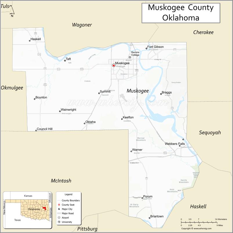
About Muskogee County Map, Oklahoma: The map showing the county boundary, county seat, major cities, highways, water bodies and neighbouring counties.
Related Oklahoma Maps
About Muskogee County, Oklahoma
Muskogee County is a county located in the U.S. state of Oklahoma. It's county seat is Muskogee. As per 2020 census, the population of Muskogee County is 66146 people and population density is 81.26 square miles. According to the United States Census Bureau, the county has a total area of 814 sq mi (2,108 km2). Muskogee County was established on 1907.
Muskogee County Facts
| Continent | North America |
| Country | United States |
| State | Oklahoma |
| County Seat | Muskogee |
| Largest City/Town | Muskogee |
| Established | 1907 |
| Total Area | 840 sq mi (2,176 sq km) |
| Land Area | 810 sq mi (2,098 sq km) |
| Water Area | 30 sq mi (78 sq km) |
| Population | 66,278 (Census 2020) |
| Population Density | 81.8 people per sq mi |
| Time Zone | Central Time Zone (CST/CDT) |
| Major Highways | U.S. Route 62, U.S. Route 69, U.S. Route 64, Interstate 40 nearby region |
| Major Rivers | Arkansas River, Verdigris River, Grand River |
| Neighboring Counties | Wagoner County, Cherokee County, McIntosh County, Sequoyah County, Okmulgee County |
| Famous For | The Oklahoma Music Hall of Fame, Honor Heights Park, Native American heritage, and river transportation history |
| Top Attractions | Honor Heights Park, Oklahoma Music Hall of Fame, Five Civilized Tribes Museum, and River Country recreation |
| Official Website | Official Website |
About Muskogee County, Oklahoma
Muskogee County is located in eastern Oklahoma and was established in 1907 from former Creek and Cherokee Nation territories. The county seat and largest city is Muskogee. The county is known for Native American heritage, music history, river transportation, agriculture, and cultural attractions.
Cities and Towns in Muskogee County, Oklahoma
| City/Town | Population (Census 2020) | Latitude & Longitude |
|---|---|---|
| Muskogee (county seat) | 36,878 | 35.7479°N, 95.3697°W |
| Fort Gibson | 3,981 | 35.7981°N, 95.2505°W |
| Haskell | 1,924 | 35.8215°N, 95.6744°W |
| Warner | 1,430 | 35.4943°N, 95.3050°W |
| Okay | 621 | 35.8504°N, 95.3208°W |
| Porum nearby region | 725 | 35.3551°N, 95.2672°W |
Golf Courses in Muskogee County, Oklahoma
| Golf Course | Location | Latitude & Longitude |
|---|---|---|
| Muskogee Country Club | Muskogee | 35.7606°N, 95.3904°W |
| Arrowhead Golf Course | Muskogee | 35.7318°N, 95.3487°W |
| Fort Gibson Lake Recreation Golf Area | Fort Gibson nearby region | 35.8137°N, 95.2874°W |
Major Roads and Highways in Muskogee County, Oklahoma
Major highways connect Muskogee County with Tulsa, eastern Oklahoma, and Arkansas.
- U.S. Route 62 - important east-west transportation corridor
- U.S. Route 69 - major north-south highway through eastern Oklahoma
- U.S. Route 64 - regional transportation route serving river communities
- Interstate 40 nearby region - major interstate access through eastern Oklahoma
What are the Neighboring Counties of Muskogee County
- Wagoner County (north)
- Cherokee County (east)
- Sequoyah County (southeast)
- McIntosh County (south)
- Okmulgee County (west)
What are the Top Places to Visit in Muskogee County, Oklahoma
The county offers museums, parks, lakes, and cultural attractions throughout eastern Oklahoma.
- Honor Heights Park - botanical gardens, azaleas, and walking trails
- Oklahoma Music Hall of Fame - exhibits on Oklahoma musicians and music history
- Five Civilized Tribes Museum - Native American history and cultural exhibits
- Fort Gibson Historic Site nearby region - military and frontier history attractions
- River Country Family Water Park - family recreation and entertainment
- Fort Gibson Lake nearby region - boating, fishing, and camping opportunities
- Historic Downtown Muskogee - local restaurants, shops, and cultural attractions
- Fishing and Wildlife Areas - outdoor recreation and birdwatching
- Community Festivals and Events - music, rodeos, and seasonal entertainment
- Nature Trails and Scenic Drives - countryside landscapes and photography
What is the Distance from Muskogee County to Nearby Cities
The following distances are measured by road (driving).
- Muskogee to Tulsa (Tulsa County), Oklahoma - 49 mi (79 km)
- Muskogee to Fort Smith (Sebastian County), Arkansas - 82 mi (132 km)
- Muskogee to Oklahoma City (Oklahoma County), Oklahoma - 145 mi (233 km)
- Muskogee to Fort Gibson (Muskogee County), Oklahoma - 9 mi (14 km)
- Muskogee to Warner (Muskogee County), Oklahoma - 23 mi (37 km)
- Muskogee to Fayetteville (Washington County), Arkansas - 105 mi (169 km)
- Muskogee to Joplin (Jasper County), Missouri - 121 mi (195 km)
- Muskogee to Little Rock (Pulaski County), Arkansas - 186 mi (299 km)
- Muskogee to Dallas (Dallas County), Texas - 268 mi (431 km)
- Muskogee to Kansas City (Jackson County), Missouri - 247 mi (398 km)
- Muskogee to Amarillo (Potter County), Texas - 432 mi (695 km)
- Muskogee to Denver (Denver County), Colorado - 652 mi (1,049 km)
- Muskogee to Chicago (Cook County), Illinois - 603 mi (970 km)
FAQs about Muskogee County
Muskogee County is located in eastern Oklahoma.
Muskogee County had a population of 66,278 according to the 2020 United States Census.
Muskogee County is known for Native American heritage, music history, museums, and river transportation history.
The county is served by U.S. Route 62, U.S. Route 69, U.S. Route 64, and nearby Interstate 40.
Yes, Muskogee County includes golf facilities such as Muskogee Country Club and Arrowhead Golf Course.
References
- QuickFacts - U.S. Census Bureau
- United States Census Bureau
- United States Geological Survey (USGS)
- National Geodetic Survey
- Official Website
- Adair County Map
- Alfalfa County Map
- Atoka County Map
- Beaver County Map
- Beckham County Map
- Blaine County Map
- Bryan County Map
- Caddo County Map
- Canadian County Map
- Carter County Map
- Cherokee County Map
- Choctaw County Map
- Cimarron County Map
- Cleveland County Map
- Coal County Map
- Comanche County Map
- Cotton County Map
- Craig County Map
- Creek County Map
- Custer County Map
- Delaware County Map
- Dewey County Map
- Ellis County Map
- Garfield County Map
- Garvin County Map
- Grady County Map
- Grant County Map
- Greer County Map
- Harmon County Map
- Harper County Map
- Haskell County Map
- Hughes County Map
- Jackson County Map
- Jefferson County Map
- Johnston County Map
- Kay County Map
- Kingfisher County Map
- Kiowa County Map
- Latimer County Map
- Le Flore County Map
- Lincoln County Map
- Logan County Map
- Love County Map
- McClain County Map
- McCurtain County Map
- McIntosh County Map
- Major County Map
- Marshall County Map
- Mayes County Map
- Murray County Map
- Muskogee County Map
- Noble County Map
- Nowata County Map
- Okfuskee County Map
- Oklahoma County Map
- Okmulgee County Map
- Osage County Map
- Ottawa County Map
- Pawnee County Map
- Payne County Map
- Pittsburg County Map
- Pontotoc County Map
- Pottawatomie County Map
- Pushmataha County Map
- Roger Mills County Map
- Rogers County Map
- Seminole County Map
- Sequoyah County Map
- Stephens County Map
- Texas County Map
- Tillman County Map
- Tulsa County Map
- Wagoner County Map
- Washington County Map
- Washita County Map
- Woods County Map
- Woodward County Map
- Alabama Counties
- Alaska boroughs
- Arizona Counties
- Arkansas Counties
- California County Map
- Colorado Counties
- Connecticut Counties
- Delaware Counties
- Florida County Map
- Georgia County Map
- Hawaii Counties
- Idaho Counties
- Illinois Counties
- Indiana Counties
- Iowa Counties
- Kansas Counties
- Kentucky Counties
- Louisiana Counties
- Maine Counties
- Maryland Counties
- Massachusetts Counties
- Michigan County Map
- Minnesota Counties
- Mississippi Counties
- Missouri Counties
- Montana Counties
- Nebraska Counties
- Nevada Counties
- New York Counties
- New Hampshire Counties
- New Jersey Counties
- New Mexico Counties
- North Carolina Counties
- North Dakota Counties
- Ohio County Map
- Oklahoma Counties
- Oregon Counties
- Pennsylvania Counties
- Rhode Island Counties
- South Carolina Counties
- South Dakota Counties
- Map of Tennessee
- Texas County Map
- Utah Counties
- Vermont Counties
- Virginia Counties
- Washington Counties
- West Virginia Counties
- Wisconsin Counties
- Wyoming Counties