Written and Fact-checked by Whereig Editors, Reviewed by Mukesh Kumar| Updated On: May 15, 2026
Map of Le Flore County - Le Flore County is a county located in the U.S. state of Oklahoma. Le Flore County Map showing cities, highways, important places and water bodies. Get Where is Le Flore County located in the map, major cities in Le Flore county, population, areas, and places of interest.
Map of Le Flore County, Oklahoma
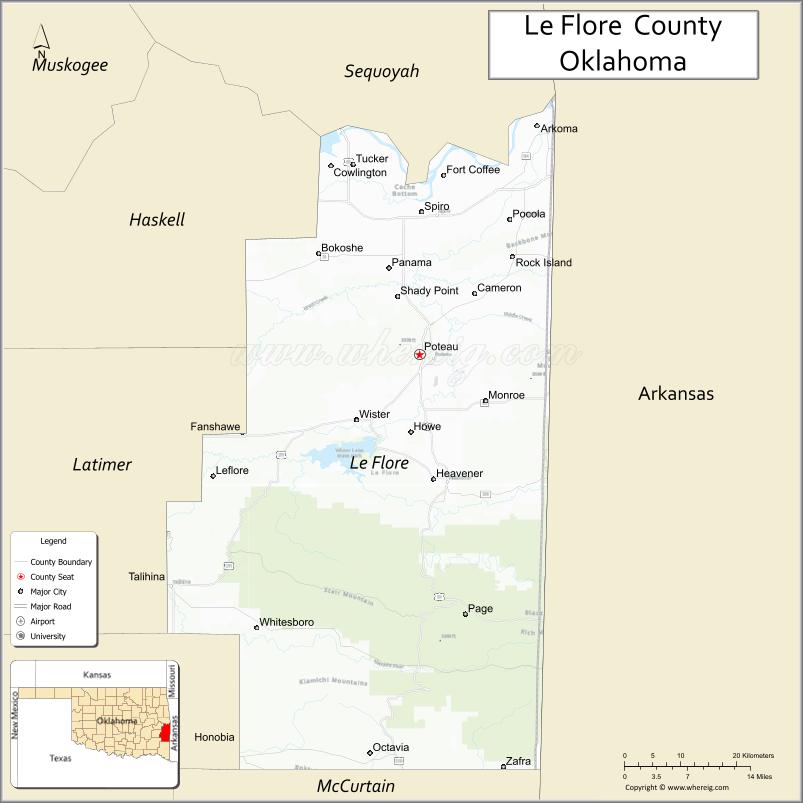
About Le Flore County Map, Oklahoma: The map showing the county boundary, county seat, major cities, highways, water bodies and neighbouring counties.
Related Oklahoma Maps
About Le Flore County, Oklahoma
Le Flore County is a county located in the U.S. state of Oklahoma. It's county seat is Poteau. As per 2020 census, the population of Le Flore County is 48476 people and population density is 30.56 square miles. According to the United States Census Bureau, the county has a total area of 1,586 sq mi (4,108 km2). Le Flore County was established on 1907.
Le Flore County Facts
| Continent | North America |
| Country | United States |
| State | Oklahoma |
| County Seat | Poteau |
| Largest City/Town | Poteau |
| Established | 1907 |
| Total Area | 1,608 sq mi (4,164 sq km) |
| Land Area | 1,589 sq mi (4,116 sq km) |
| Water Area | 19 sq mi (49 sq km) |
| Population | 48,129 (Census 2020) |
| Population Density | 30.3 people per sq mi |
| Time Zone | Central Time Zone (CST/CDT) |
| Major Highways | U.S. Route 59, U.S. Route 271, State Highway 112, Interstate 40 nearby region |
| Major Rivers | Poteau River, Arkansas River nearby region, Fourche Maline River |
| Neighboring Counties | Sequoyah County, Haskell County, Latimer County, Pushmataha County, McCurtain County, Scott County (Arkansas), Sebastian County (Arkansas) |
| Famous For | Ouachita Mountains, Talimena Scenic Drive nearby region, outdoor recreation, and forestry heritage |
| Top Attractions | Talimena Scenic Drive nearby region, Heavener Runestone Park, Lake Wister State Park, and Poteau attractions |
| Official Website | Official Website |
About Le Flore County, Oklahoma
Le Flore County is located in southeastern Oklahoma along the Arkansas border and was established in 1907 from former Choctaw Nation territory. The county seat and largest city is Poteau. The county is known for mountains, forests, scenic drives, lakes, and outdoor recreation opportunities in the Ouachita Mountains region.
Cities and Towns in Le Flore County, Oklahoma
| City/Town | Population (Census 2020) | Latitude & Longitude |
|---|---|---|
| Poteau (county seat) | 8,573 | 35.0531°N, 94.6230°W |
| Heavener | 3,414 | 34.8898°N, 94.6008°W |
| Spiro | 2,227 | 35.2418°N, 94.6194°W |
| Talihina | 1,024 | 34.7504°N, 95.0483°W |
| Wister | 998 | 34.9670°N, 94.7247°W |
| Howe | 791 | 34.9515°N, 94.6377°W |
Golf Courses in Le Flore County, Oklahoma
| Golf Course | Location | Latitude & Longitude |
|---|---|---|
| Poteau Country Club | Poteau | 35.0672°N, 94.6374°W |
| Wolf Ridge Country Club | Heavener nearby region | 34.9014°N, 94.6172°W |
| Lake Wister Recreation Golf Area | Lake Wister nearby region | 34.9551°N, 94.7365°W |
Major Roads and Highways in Le Flore County, Oklahoma
Major highways connect Le Flore County with southeastern Oklahoma, Arkansas, and mountain recreation regions.
- U.S. Route 59 - major north-south transportation corridor through eastern Oklahoma
- U.S. Route 271 - important route connecting Oklahoma and Arkansas
- State Highway 112 - scenic highway serving mountain communities
- Interstate 40 nearby region - major interstate access to eastern Oklahoma
What are the Neighboring Counties of Le Flore County
- Sequoyah County (north)
- Haskell County (northwest)
- Latimer County (west)
- Pushmataha County (southwest)
- McCurtain County (south)
- Scott County, Arkansas (east)
- Sebastian County, Arkansas (northeast)
What are the Top Places to Visit in Le Flore County, Oklahoma
The county offers mountains, lakes, forests, scenic drives, and outdoor recreation opportunities.
- Talimena Scenic Drive nearby region - mountain views, fall foliage, and scenic overlooks
- Heavener Runestone Park - Viking history exhibits, hiking trails, and scenic recreation
- Lake Wister State Park - boating, fishing, camping, and lakeside recreation
- Cavanal Hill in Poteau - known as the world's highest hill with scenic overlooks
- Ouachita National Forest nearby region - hiking, wildlife viewing, and camping
- Historic Downtown Poteau - local shops, restaurants, and cultural attractions
- Fishing and Wildlife Areas - outdoor recreation and birdwatching opportunities
- Mountain Scenic Drives - photography and nature exploration
- Community Festivals and Rodeos - regional traditions and entertainment
- Camping and RV Parks - mountain vacations and family recreation
What is the Distance from Le Flore County to Nearby Cities
The following distances are measured by road (driving).
- Poteau to Fort Smith (Sebastian County), Arkansas - 31 mi (50 km)
- Poteau to McAlester (Pittsburg County), Oklahoma - 72 mi (116 km)
- Poteau to Tulsa (Tulsa County), Oklahoma - 118 mi (190 km)
- Poteau to Oklahoma City (Oklahoma County), Oklahoma - 185 mi (298 km)
- Poteau to Heavener (Le Flore County), Oklahoma - 12 mi (19 km)
- Poteau to Spiro (Le Flore County), Oklahoma - 13 mi (21 km)
- Poteau to Little Rock (Pulaski County), Arkansas - 165 mi (266 km)
- Poteau to Dallas (Dallas County), Texas - 245 mi (394 km)
- Poteau to Fayetteville (Washington County), Arkansas - 91 mi (146 km)
- Poteau to Kansas City (Jackson County), Missouri - 274 mi (441 km)
- Poteau to Amarillo (Potter County), Texas - 465 mi (748 km)
- Poteau to Denver (Denver County), Colorado - 742 mi (1,194 km)
- Poteau to Chicago (Cook County), Illinois - 652 mi (1,049 km)
FAQs about Le Flore County
Le Flore County is located in southeastern Oklahoma along the Arkansas border.
Le Flore County had a population of 48,129 according to the 2020 United States Census.
Le Flore County is known for the Ouachita Mountains, Talimena Scenic Drive, forests, and outdoor recreation.
The county is served by U.S. Route 59, U.S. Route 271, State Highway 112, and nearby Interstate 40.
Yes, Le Flore County includes golf facilities near Poteau, Heavener, and Lake Wister.
References
- QuickFacts - U.S. Census Bureau
- United States Census Bureau
- United States Geological Survey (USGS)
- National Geodetic Survey
- Official Website
- Adair County Map
- Alfalfa County Map
- Atoka County Map
- Beaver County Map
- Beckham County Map
- Blaine County Map
- Bryan County Map
- Caddo County Map
- Canadian County Map
- Carter County Map
- Cherokee County Map
- Choctaw County Map
- Cimarron County Map
- Cleveland County Map
- Coal County Map
- Comanche County Map
- Cotton County Map
- Craig County Map
- Creek County Map
- Custer County Map
- Delaware County Map
- Dewey County Map
- Ellis County Map
- Garfield County Map
- Garvin County Map
- Grady County Map
- Grant County Map
- Greer County Map
- Harmon County Map
- Harper County Map
- Haskell County Map
- Hughes County Map
- Jackson County Map
- Jefferson County Map
- Johnston County Map
- Kay County Map
- Kingfisher County Map
- Kiowa County Map
- Latimer County Map
- Le Flore County Map
- Lincoln County Map
- Logan County Map
- Love County Map
- McClain County Map
- McCurtain County Map
- McIntosh County Map
- Major County Map
- Marshall County Map
- Mayes County Map
- Murray County Map
- Muskogee County Map
- Noble County Map
- Nowata County Map
- Okfuskee County Map
- Oklahoma County Map
- Okmulgee County Map
- Osage County Map
- Ottawa County Map
- Pawnee County Map
- Payne County Map
- Pittsburg County Map
- Pontotoc County Map
- Pottawatomie County Map
- Pushmataha County Map
- Roger Mills County Map
- Rogers County Map
- Seminole County Map
- Sequoyah County Map
- Stephens County Map
- Texas County Map
- Tillman County Map
- Tulsa County Map
- Wagoner County Map
- Washington County Map
- Washita County Map
- Woods County Map
- Woodward County Map
- Alabama Counties
- Alaska boroughs
- Arizona Counties
- Arkansas Counties
- California County Map
- Colorado Counties
- Connecticut Counties
- Delaware Counties
- Florida County Map
- Georgia County Map
- Hawaii Counties
- Idaho Counties
- Illinois Counties
- Indiana Counties
- Iowa Counties
- Kansas Counties
- Kentucky Counties
- Louisiana Counties
- Maine Counties
- Maryland Counties
- Massachusetts Counties
- Michigan County Map
- Minnesota Counties
- Mississippi Counties
- Missouri Counties
- Montana Counties
- Nebraska Counties
- Nevada Counties
- New York Counties
- New Hampshire Counties
- New Jersey Counties
- New Mexico Counties
- North Carolina Counties
- North Dakota Counties
- Ohio County Map
- Oklahoma Counties
- Oregon Counties
- Pennsylvania Counties
- Rhode Island Counties
- South Carolina Counties
- South Dakota Counties
- Map of Tennessee
- Texas County Map
- Utah Counties
- Vermont Counties
- Virginia Counties
- Washington Counties
- West Virginia Counties
- Wisconsin Counties
- Wyoming Counties