Written and Fact-checked by Whereig Editors, Reviewed by Mukesh Kumar| Updated On: May 15, 2026
Map of Osage County - Osage County is a county located in the U.S. state of Oklahoma. Osage County Map showing cities, highways, important places and water bodies. Get Where is Osage County located in the map, major cities in Osage county, population, areas, and places of interest.
Map of Osage County, Oklahoma
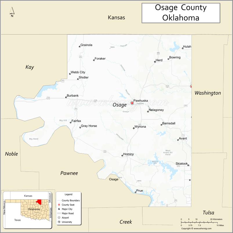
About Osage County Map, Oklahoma: The map showing the county boundary, county seat, major cities, highways, water bodies and neighbouring counties.
Related Oklahoma Maps
About Osage County, Oklahoma
Osage County is a county located in the U.S. state of Oklahoma. It's county seat is Pawhuska. As per 2020 census, the population of Osage County is 45772 people and population density is 20.33 square miles. According to the United States Census Bureau, the county has a total area of 2,251 sq mi (5,830 km2). Osage County was established on 1907.
Osage County Facts
| Continent | North America |
| Country | United States |
| State | Oklahoma |
| County Seat | Pawhuska |
| Largest City/Town | Pawhuska |
| Established | 1907 |
| Total Area | 2,304 sq mi (5,967 sq km) |
| Land Area | 2,246 sq mi (5,817 sq km) |
| Water Area | 58 sq mi (150 sq km) |
| Population | 45,818 (Census 2020) |
| Population Density | 20.4 people per sq mi |
| Time Zone | Central Time Zone (CST/CDT) |
| Major Highways | U.S. Route 60, U.S. Route 75, State Highway 99 |
| Major Rivers | Arkansas River, Caney River, Bird Creek |
| Neighboring Counties | Washington County, Nowata County, Tulsa County, Pawnee County, Kay County, Chautauqua County (Kansas) |
| Famous For | Osage Nation heritage, Tallgrass Prairie Preserve, oil history, and ranching culture |
| Top Attractions | Tallgrass Prairie Preserve, Pawhuska attractions, The Pioneer Woman Mercantile, and Osage Nation Museum |
| Official Website | Official Website |
About Osage County, Oklahoma
Osage County is located in north-central Oklahoma and is the largest county in the state by area. Established in 1907 from Osage Nation lands, the county seat and largest city is Pawhuska. The county is known for Native American heritage, cattle ranching, prairie landscapes, oil history, and the Tallgrass Prairie Preserve.
Cities and Towns in Osage County, Oklahoma
| City/Town | Population (Census 2020) | Latitude & Longitude |
|---|---|---|
| Pawhuska (county seat) | 3,400 | 36.6670°N, 96.3372°W |
| Bartlesville nearby region | 37,290 | 36.7473°N, 95.9808°W |
| Skiatook | 8,353 | 36.3684°N, 96.0014°W |
| Hominy | 3,565 | 36.4145°N, 96.3953°W |
| Fairfax | 1,286 | 36.5731°N, 96.7053°W |
| Shidler | 328 | 36.7812°N, 96.6670°W |
Golf Courses in Osage County, Oklahoma
| Golf Course | Location | Latitude & Longitude |
|---|---|---|
| Pawhuska Golf and Country Club | Pawhuska | 36.6765°N, 96.3538°W |
| Skiatook Country Club | Skiatook | 36.3811°N, 96.0145°W |
| Hominy Community Golf Area | Hominy nearby region | 36.4234°N, 96.4092°W |
Major Roads and Highways in Osage County, Oklahoma
Major highways connect Osage County with Tulsa, Kansas, and north-central Oklahoma ranching communities.
- U.S. Route 60 - major east-west transportation corridor across northern Oklahoma
- U.S. Route 75 - important north-south highway through Oklahoma
- State Highway 99 - regional transportation route serving ranching communities
What are the Neighboring Counties of Osage County
- Chautauqua County, Kansas (north)
- Washington County (northeast)
- Nowata County (east)
- Tulsa County (southeast)
- Pawnee County (south)
- Kay County (west)
What are the Top Places to Visit in Osage County, Oklahoma
The county offers prairie preserves, Native American heritage sites, museums, and outdoor recreation opportunities.
- Tallgrass Prairie Preserve - bison herds, hiking, and scenic prairie landscapes
- The Pioneer Woman Mercantile - restaurant, bakery, and shopping destination in Pawhuska
- Osage Nation Museum - exhibits on Osage history and Native American culture
- Historic Downtown Pawhuska - architecture, boutiques, and local attractions
- Woolaroc Museum and Wildlife Preserve nearby region - western art and wildlife exhibits
- Skiatook Lake nearby region - boating, fishing, camping, and recreation
- Fishing and Wildlife Areas - birdwatching and outdoor exploration
- Prairie Scenic Drives - photography and ranching landscapes
- Community Rodeos and Festivals - western traditions and seasonal entertainment
- Nature Trails and Recreation Areas - hiking and environmental education
What is the Distance from Osage County to Nearby Cities
The following distances are measured by road (driving).
- Pawhuska to Tulsa (Tulsa County), Oklahoma - 58 mi (93 km)
- Pawhuska to Bartlesville (Washington County), Oklahoma - 28 mi (45 km)
- Pawhuska to Ponca City (Kay County), Oklahoma - 48 mi (77 km)
- Pawhuska to Oklahoma City (Oklahoma County), Oklahoma - 117 mi (188 km)
- Pawhuska to Hominy (Osage County), Oklahoma - 27 mi (43 km)
- Pawhuska to Fairfax (Osage County), Oklahoma - 33 mi (53 km)
- Pawhuska to Wichita (Sedgwick County), Kansas - 123 mi (198 km)
- Pawhuska to Kansas City (Jackson County), Missouri - 242 mi (389 km)
- Pawhuska to Dallas (Dallas County), Texas - 301 mi (484 km)
- Pawhuska to Little Rock (Pulaski County), Arkansas - 331 mi (533 km)
- Pawhuska to Amarillo (Potter County), Texas - 382 mi (615 km)
- Pawhuska to Denver (Denver County), Colorado - 569 mi (916 km)
- Pawhuska to Chicago (Cook County), Illinois - 602 mi (969 km)
FAQs about Osage County
Osage County is located in north-central Oklahoma.
Osage County had a population of 45,818 according to the 2020 United States Census.
Osage County is known for Osage Nation heritage, ranching culture, oil history, and the Tallgrass Prairie Preserve.
The county is served by U.S. Route 60, U.S. Route 75, and State Highway 99.
Yes, Osage County includes golf facilities near Pawhuska, Skiatook, and Hominy.
References
- QuickFacts - U.S. Census Bureau
- United States Census Bureau
- United States Geological Survey (USGS)
- National Geodetic Survey
- Official Website
- Adair County Map
- Alfalfa County Map
- Atoka County Map
- Beaver County Map
- Beckham County Map
- Blaine County Map
- Bryan County Map
- Caddo County Map
- Canadian County Map
- Carter County Map
- Cherokee County Map
- Choctaw County Map
- Cimarron County Map
- Cleveland County Map
- Coal County Map
- Comanche County Map
- Cotton County Map
- Craig County Map
- Creek County Map
- Custer County Map
- Delaware County Map
- Dewey County Map
- Ellis County Map
- Garfield County Map
- Garvin County Map
- Grady County Map
- Grant County Map
- Greer County Map
- Harmon County Map
- Harper County Map
- Haskell County Map
- Hughes County Map
- Jackson County Map
- Jefferson County Map
- Johnston County Map
- Kay County Map
- Kingfisher County Map
- Kiowa County Map
- Latimer County Map
- Le Flore County Map
- Lincoln County Map
- Logan County Map
- Love County Map
- McClain County Map
- McCurtain County Map
- McIntosh County Map
- Major County Map
- Marshall County Map
- Mayes County Map
- Murray County Map
- Muskogee County Map
- Noble County Map
- Nowata County Map
- Okfuskee County Map
- Oklahoma County Map
- Okmulgee County Map
- Osage County Map
- Ottawa County Map
- Pawnee County Map
- Payne County Map
- Pittsburg County Map
- Pontotoc County Map
- Pottawatomie County Map
- Pushmataha County Map
- Roger Mills County Map
- Rogers County Map
- Seminole County Map
- Sequoyah County Map
- Stephens County Map
- Texas County Map
- Tillman County Map
- Tulsa County Map
- Wagoner County Map
- Washington County Map
- Washita County Map
- Woods County Map
- Woodward County Map
- Alabama Counties
- Alaska boroughs
- Arizona Counties
- Arkansas Counties
- California County Map
- Colorado Counties
- Connecticut Counties
- Delaware Counties
- Florida County Map
- Georgia County Map
- Hawaii Counties
- Idaho Counties
- Illinois Counties
- Indiana Counties
- Iowa Counties
- Kansas Counties
- Kentucky Counties
- Louisiana Counties
- Maine Counties
- Maryland Counties
- Massachusetts Counties
- Michigan County Map
- Minnesota Counties
- Mississippi Counties
- Missouri Counties
- Montana Counties
- Nebraska Counties
- Nevada Counties
- New York Counties
- New Hampshire Counties
- New Jersey Counties
- New Mexico Counties
- North Carolina Counties
- North Dakota Counties
- Ohio County Map
- Oklahoma Counties
- Oregon Counties
- Pennsylvania Counties
- Rhode Island Counties
- South Carolina Counties
- South Dakota Counties
- Map of Tennessee
- Texas County Map
- Utah Counties
- Vermont Counties
- Virginia Counties
- Washington Counties
- West Virginia Counties
- Wisconsin Counties
- Wyoming Counties