Written and Fact-checked by Whereig Editors, Reviewed by Mukesh Kumar| Updated On: May 15, 2026
Map of Lincoln County - Lincoln County is a county located in the U.S. state of Oklahoma. Lincoln County Map showing cities, highways, important places and water bodies. Get Where is Lincoln County located in the map, major cities in Lincoln county, population, areas, and places of interest.
Map of Lincoln County, Oklahoma
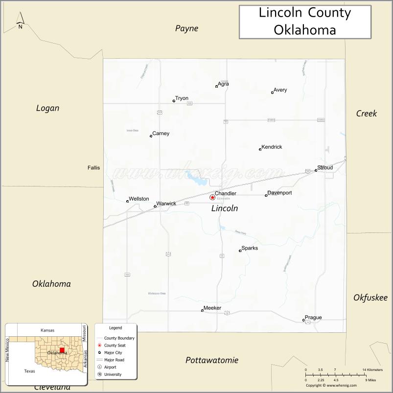
About Lincoln County Map, Oklahoma: The map showing the county boundary, county seat, major cities, highways, water bodies and neighbouring counties.
Related Oklahoma Maps
About Lincoln County, Oklahoma
Lincoln County is a county located in the U.S. state of Oklahoma. It's county seat is Chandler. As per 2020 census, the population of Lincoln County is 33829 people and population density is 35.28 square miles. According to the United States Census Bureau, the county has a total area of 959 sq mi (2,484 km2). Lincoln County was established on 1891.
Lincoln County Facts
| Continent | North America |
| Country | United States |
| State | Oklahoma |
| County Seat | Chandler |
| Largest City/Town | Stroud |
| Established | 1891 |
| Total Area | 966 sq mi (2,502 sq km) |
| Land Area | 952 sq mi (2,466 sq km) |
| Water Area | 14 sq mi (36 sq km) |
| Population | 34,877 (Census 2020) |
| Population Density | 36.6 people per sq mi |
| Time Zone | Central Time Zone (CST/CDT) |
| Major Highways | Interstate 44, U.S. Route 62, State Highway 18, Historic Route 66 |
| Major Rivers | Deep Fork River, North Canadian River nearby region |
| Neighboring Counties | Payne County, Creek County, Okfuskee County, Pottawatomie County, Logan County, Oklahoma County |
| Famous For | Historic Route 66, agriculture, Chandler museums, and central Oklahoma heritage |
| Top Attractions | Route 66 Interpretive Center, Chandler Museum of the Pioneer West, Stroud attractions, and outdoor recreation areas |
| Official Website | Official Website |
About Lincoln County, Oklahoma
Lincoln County is located in central Oklahoma and was established during the Land Run of 1891. The county seat is Chandler, while Stroud is the largest city. The county is known for agriculture, Route 66 history, prairie landscapes, and small-town Oklahoma culture.
Cities and Towns in Lincoln County, Oklahoma
| City/Town | Population (Census 2020) | Latitude & Longitude |
|---|---|---|
| Stroud | 2,719 | 35.7470°N, 96.6550°W |
| Chandler (county seat) | 2,790 | 35.7017°N, 96.8809°W |
| Prague | 2,386 | 35.4862°N, 96.6856°W |
| Davenport | 790 | 35.7117°N, 96.7656°W |
| Meeker | 1,114 | 35.5009°N, 96.9036°W |
| Wellston | 599 | 35.6942°N, 97.0633°W |
Golf Courses in Lincoln County, Oklahoma
| Golf Course | Location | Latitude & Longitude |
|---|---|---|
| Chandler Municipal Golf Course | Chandler | 35.7158°N, 96.8947°W |
| Stroud Country Club | Stroud | 35.7603°N, 96.6701°W |
| Prague Golf and Recreation Area | Prague nearby region | 35.4994°N, 96.6972°W |
Major Roads and Highways in Lincoln County, Oklahoma
Major highways connect Lincoln County with Oklahoma City, Tulsa, and regional agricultural communities.
- Interstate 44 - major interstate connecting Oklahoma City and Tulsa
- U.S. Route 62 - important east-west transportation route
- State Highway 18 - regional north-south transportation corridor
- Historic Route 66 - famous historic highway crossing the county
What are the Neighboring Counties of Lincoln County
- Payne County (north)
- Creek County (east)
- Okfuskee County (south)
- Pottawatomie County (southwest)
- Oklahoma County (west)
- Logan County (northwest)
What are the Top Places to Visit in Lincoln County, Oklahoma
The county offers Route 66 attractions, museums, prairie scenery, and outdoor recreation opportunities.
- Route 66 Interpretive Center - exhibits on the history and culture of Route 66
- Chandler Museum of the Pioneer West - local history and pioneer heritage exhibits
- Historic Downtown Stroud - Route 66 shops, restaurants, and entertainment
- Prague Kolache Festival - annual celebration of Czech heritage and local culture
- Fishing and Wildlife Areas - outdoor recreation and birdwatching opportunities
- Prairie Scenic Drives - countryside photography and rural Oklahoma landscapes
- Community Rodeos and Festivals - western traditions and seasonal entertainment
- Camping and RV Parks - family recreation and outdoor activities
- Historic Route 66 Landmarks - classic roadside attractions and diners
- Nature Trails and Recreation Areas - hiking and environmental exploration
What is the Distance from Lincoln County to Nearby Cities
The following distances are measured by road (driving).
- Chandler to Oklahoma City (Oklahoma County), Oklahoma - 50 mi (80 km)
- Chandler to Tulsa (Tulsa County), Oklahoma - 67 mi (108 km)
- Chandler to Stillwater (Payne County), Oklahoma - 46 mi (74 km)
- Chandler to Shawnee (Pottawatomie County), Oklahoma - 33 mi (53 km)
- Chandler to Stroud (Lincoln County), Oklahoma - 15 mi (24 km)
- Chandler to Prague (Lincoln County), Oklahoma - 22 mi (35 km)
- Chandler to Wichita (Sedgwick County), Kansas - 182 mi (293 km)
- Chandler to Dallas (Dallas County), Texas - 220 mi (354 km)
- Chandler to Amarillo (Potter County), Texas - 306 mi (492 km)
- Chandler to Kansas City (Jackson County), Missouri - 310 mi (499 km)
- Chandler to Little Rock (Pulaski County), Arkansas - 306 mi (492 km)
- Chandler to Denver (Denver County), Colorado - 605 mi (974 km)
- Chandler to Chicago (Cook County), Illinois - 727 mi (1,170 km)
FAQs about Lincoln County
Lincoln County is located in central Oklahoma.
Lincoln County had a population of 34,877 according to the 2020 United States Census.
Lincoln County is known for Historic Route 66, agriculture, museums, and small-town Oklahoma heritage.
The county is served by Interstate 44, U.S. Route 62, State Highway 18, and Historic Route 66.
Yes, Lincoln County includes golf facilities near Chandler, Stroud, and Prague.
References
- QuickFacts - U.S. Census Bureau
- United States Census Bureau
- United States Geological Survey (USGS)
- National Geodetic Survey
- Official Website
- Adair County Map
- Alfalfa County Map
- Atoka County Map
- Beaver County Map
- Beckham County Map
- Blaine County Map
- Bryan County Map
- Caddo County Map
- Canadian County Map
- Carter County Map
- Cherokee County Map
- Choctaw County Map
- Cimarron County Map
- Cleveland County Map
- Coal County Map
- Comanche County Map
- Cotton County Map
- Craig County Map
- Creek County Map
- Custer County Map
- Delaware County Map
- Dewey County Map
- Ellis County Map
- Garfield County Map
- Garvin County Map
- Grady County Map
- Grant County Map
- Greer County Map
- Harmon County Map
- Harper County Map
- Haskell County Map
- Hughes County Map
- Jackson County Map
- Jefferson County Map
- Johnston County Map
- Kay County Map
- Kingfisher County Map
- Kiowa County Map
- Latimer County Map
- Le Flore County Map
- Lincoln County Map
- Logan County Map
- Love County Map
- McClain County Map
- McCurtain County Map
- McIntosh County Map
- Major County Map
- Marshall County Map
- Mayes County Map
- Murray County Map
- Muskogee County Map
- Noble County Map
- Nowata County Map
- Okfuskee County Map
- Oklahoma County Map
- Okmulgee County Map
- Osage County Map
- Ottawa County Map
- Pawnee County Map
- Payne County Map
- Pittsburg County Map
- Pontotoc County Map
- Pottawatomie County Map
- Pushmataha County Map
- Roger Mills County Map
- Rogers County Map
- Seminole County Map
- Sequoyah County Map
- Stephens County Map
- Texas County Map
- Tillman County Map
- Tulsa County Map
- Wagoner County Map
- Washington County Map
- Washita County Map
- Woods County Map
- Woodward County Map
- Alabama Counties
- Alaska boroughs
- Arizona Counties
- Arkansas Counties
- California County Map
- Colorado Counties
- Connecticut Counties
- Delaware Counties
- Florida County Map
- Georgia County Map
- Hawaii Counties
- Idaho Counties
- Illinois Counties
- Indiana Counties
- Iowa Counties
- Kansas Counties
- Kentucky Counties
- Louisiana Counties
- Maine Counties
- Maryland Counties
- Massachusetts Counties
- Michigan County Map
- Minnesota Counties
- Mississippi Counties
- Missouri Counties
- Montana Counties
- Nebraska Counties
- Nevada Counties
- New York Counties
- New Hampshire Counties
- New Jersey Counties
- New Mexico Counties
- North Carolina Counties
- North Dakota Counties
- Ohio County Map
- Oklahoma Counties
- Oregon Counties
- Pennsylvania Counties
- Rhode Island Counties
- South Carolina Counties
- South Dakota Counties
- Map of Tennessee
- Texas County Map
- Utah Counties
- Vermont Counties
- Virginia Counties
- Washington Counties
- West Virginia Counties
- Wisconsin Counties
- Wyoming Counties