Written and Fact-checked by Whereig Editors, Reviewed by Mukesh Kumar| Updated On: May 15, 2026
Map of Carter County - Carter County is a county located in the U.S. state of Oklahoma. Carter County Map showing cities, highways, important places and water bodies. Get Where is Carter County located in the map, major cities in Carter county, population, areas, and places of interest.
Map of Carter County, Oklahoma
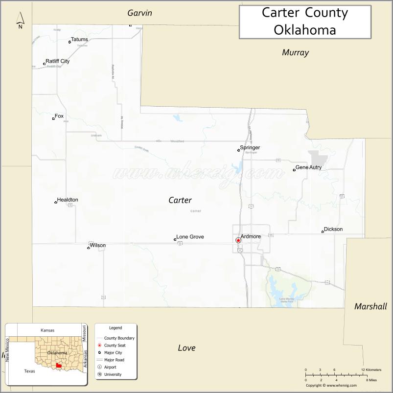
About Carter County Map, Oklahoma: The map showing the county boundary, county seat, major cities, highways, water bodies and neighbouring counties.
Related Oklahoma Maps
About Carter County, Oklahoma
Carter County is a county located in the U.S. state of Oklahoma. It's county seat is Ardmore. As per 2020 census, the population of Carter County is 48291 people and population density is 58.61 square miles. According to the United States Census Bureau, the county has a total area of 824 sq mi (2,134 km2). Carter County was established on 1907.
Carter County Facts
| Continent | North America |
| Country | United States |
| State | Oklahoma |
| County Seat | Ardmore |
| Largest City/Town | Ardmore |
| Established | 1907 |
| Total Area | 834 sq mi (2,160 sq km) |
| Land Area | 822 sq mi (2,129 sq km) |
| Water Area | 12 sq mi (31 sq km) |
| Population | 47,045 (Census 2020) |
| Population Density | 57.2 people per sq mi |
| Time Zone | Central Time Zone (CST/CDT) |
| Major Highways | Interstate 35, U.S. Route 70, U.S. Route 77, State Highway 53 |
| Major Rivers | Washita River nearby region, Hickory Creek, Lake Murray nearby region |
| Neighboring Counties | Love County, Johnston County, Marshall County, Murray County, Stephens County |
| Famous For | Lake Murray State Park, Ardmore, energy industry, and south-central Oklahoma recreation |
| Top Attractions | Lake Murray State Park, Greater Southwest Historical Museum, Ardmore Regional Park, and Tucker Tower nearby region |
| Official Website | Official Website |
About Carter County, Oklahoma
Carter County is located in south-central Oklahoma near the Texas border and was established in 1907 from former Chickasaw Nation territory. The county seat and largest city is Ardmore. The county is known for tourism, lakes, outdoor recreation, oil and gas production, and transportation access along Interstate 35.
Cities and Towns in Carter County, Oklahoma
| City/Town | Population (Census 2020) | Latitude & Longitude |
|---|---|---|
| Ardmore (county seat) | 24,698 | 34.1743°N, 97.1436°W |
| Healdton | 2,694 | 34.2334°N, 97.4892°W |
| Wilson | 1,688 | 34.1626°N, 97.4253°W |
| Dickson | 1,248 | 34.1873°N, 96.9800°W |
| Lone Grove | 5,054 | 34.1748°N, 97.2625°W |
| Springer | 700 | 34.3048°N, 97.1361°W |
Golf Courses in Carter County, Oklahoma
| Golf Course | Location | Latitude & Longitude |
|---|---|---|
| Dornick Hills Country Club | Ardmore | 34.1914°N, 97.1612°W |
| Lake Murray Golf Course | Lake Murray nearby region | 34.1272°N, 97.0854°W |
| Hillcrest Golf & Country Club | Ardmore nearby region | 34.1821°N, 97.1507°W |
Major Roads and Highways in Carter County, Oklahoma
Major highways connect Carter County with Oklahoma City, Dallas, and south-central Oklahoma recreation areas.
- Interstate 35 - major north-south interstate highway linking Oklahoma and Texas
- U.S. Route 70 - important east-west transportation corridor across southern Oklahoma
- U.S. Route 77 - regional highway serving Ardmore and nearby communities
- State Highway 53 - connector route through rural and recreation regions
What are the Neighboring Counties of Carter County
- Stephens County (west)
- Murray County (north)
- Johnston County (northeast)
- Marshall County (east)
- Love County (south)
What are the Top Places to Visit in Carter County, Oklahoma
The county offers lakes, museums, recreation parks, and outdoor tourism attractions.
- Lake Murray State Park - boating, hiking, fishing, cabins, and camping recreation
- Tucker Tower nearby region - historic stone tower overlooking Lake Murray
- Greater Southwest Historical Museum - local history and pioneer heritage exhibits
- Ardmore Regional Park - sports facilities, walking trails, and family recreation
- Historic Downtown Ardmore - shops, restaurants, and entertainment venues
- Lake Murray Nature Center - wildlife exhibits and environmental education
- Hunting and Fishing Areas - outdoor recreation and wildlife observation
- Community Festivals and Cultural Events - seasonal entertainment and local traditions
- Scenic Southern Oklahoma Drives - countryside and lake photography opportunities
- Camping and RV Parks - lakeside recreation and outdoor relaxation
What is the Distance from Carter County to Nearby Cities
The following distances are measured by road (driving).
- Ardmore to Oklahoma City (Oklahoma County), Oklahoma - 97 mi (156 km)
- Ardmore to Dallas (Dallas County), Texas - 101 mi (163 km)
- Ardmore to Wichita Falls (Wichita County), Texas - 92 mi (148 km)
- Ardmore to Durant (Bryan County), Oklahoma - 77 mi (124 km)
- Ardmore to Lone Grove (Carter County), Oklahoma - 7 mi (11 km)
- Ardmore to Healdton (Carter County), Oklahoma - 24 mi (39 km)
- Ardmore to Tulsa (Tulsa County), Oklahoma - 161 mi (259 km)
- Ardmore to Sherman (Grayson County), Texas - 56 mi (90 km)
- Ardmore to Fort Worth (Tarrant County), Texas - 120 mi (193 km)
- Ardmore to Amarillo (Potter County), Texas - 306 mi (492 km)
- Ardmore to Kansas City (Jackson County), Missouri - 376 mi (605 km)
- Ardmore to Denver (Denver County), Colorado - 696 mi (1,120 km)
- Ardmore to Chicago (Cook County), Illinois - 812 mi (1,307 km)
FAQs about Carter County
Carter County is located in south-central Oklahoma near the Texas border.
Carter County had a population of 47,045 according to the 2020 United States Census.
Carter County is known for Lake Murray State Park, Ardmore, tourism, and energy production.
The county is served by Interstate 35, U.S. Route 70, U.S. Route 77, and State Highway 53.
Yes, Carter County includes golf facilities such as Dornick Hills Country Club and Lake Murray Golf Course.
References
- QuickFacts - U.S. Census Bureau
- United States Census Bureau
- United States Geological Survey (USGS)
- National Geodetic Survey
- Official Website
- Adair County Map
- Alfalfa County Map
- Atoka County Map
- Beaver County Map
- Beckham County Map
- Blaine County Map
- Bryan County Map
- Caddo County Map
- Canadian County Map
- Carter County Map
- Cherokee County Map
- Choctaw County Map
- Cimarron County Map
- Cleveland County Map
- Coal County Map
- Comanche County Map
- Cotton County Map
- Craig County Map
- Creek County Map
- Custer County Map
- Delaware County Map
- Dewey County Map
- Ellis County Map
- Garfield County Map
- Garvin County Map
- Grady County Map
- Grant County Map
- Greer County Map
- Harmon County Map
- Harper County Map
- Haskell County Map
- Hughes County Map
- Jackson County Map
- Jefferson County Map
- Johnston County Map
- Kay County Map
- Kingfisher County Map
- Kiowa County Map
- Latimer County Map
- Le Flore County Map
- Lincoln County Map
- Logan County Map
- Love County Map
- McClain County Map
- McCurtain County Map
- McIntosh County Map
- Major County Map
- Marshall County Map
- Mayes County Map
- Murray County Map
- Muskogee County Map
- Noble County Map
- Nowata County Map
- Okfuskee County Map
- Oklahoma County Map
- Okmulgee County Map
- Osage County Map
- Ottawa County Map
- Pawnee County Map
- Payne County Map
- Pittsburg County Map
- Pontotoc County Map
- Pottawatomie County Map
- Pushmataha County Map
- Roger Mills County Map
- Rogers County Map
- Seminole County Map
- Sequoyah County Map
- Stephens County Map
- Texas County Map
- Tillman County Map
- Tulsa County Map
- Wagoner County Map
- Washington County Map
- Washita County Map
- Woods County Map
- Woodward County Map
- Alabama Counties
- Alaska boroughs
- Arizona Counties
- Arkansas Counties
- California County Map
- Colorado Counties
- Connecticut Counties
- Delaware Counties
- Florida County Map
- Georgia County Map
- Hawaii Counties
- Idaho Counties
- Illinois Counties
- Indiana Counties
- Iowa Counties
- Kansas Counties
- Kentucky Counties
- Louisiana Counties
- Maine Counties
- Maryland Counties
- Massachusetts Counties
- Michigan County Map
- Minnesota Counties
- Mississippi Counties
- Missouri Counties
- Montana Counties
- Nebraska Counties
- Nevada Counties
- New York Counties
- New Hampshire Counties
- New Jersey Counties
- New Mexico Counties
- North Carolina Counties
- North Dakota Counties
- Ohio County Map
- Oklahoma Counties
- Oregon Counties
- Pennsylvania Counties
- Rhode Island Counties
- South Carolina Counties
- South Dakota Counties
- Map of Tennessee
- Texas County Map
- Utah Counties
- Vermont Counties
- Virginia Counties
- Washington Counties
- West Virginia Counties
- Wisconsin Counties
- Wyoming Counties