Written and Fact-checked by Whereig Editors, Reviewed by Mukesh Kumar| Updated On: May 15, 2026
Map of Delaware County - Delaware County is a county located in the U.S. state of Oklahoma. Delaware County Map showing cities, highways, important places and water bodies. Get Where is Delaware County located in the map, major cities in Delaware county, population, areas, and places of interest.
Map of Delaware County, Oklahoma
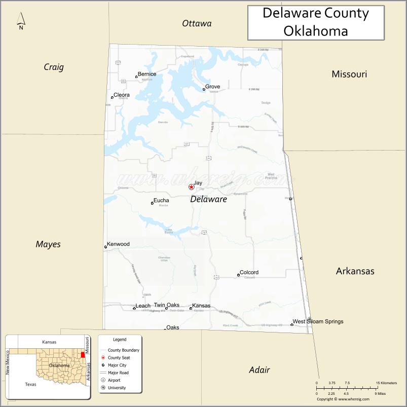
About Delaware County Map, Oklahoma: The map showing the county boundary, county seat, major cities, highways, water bodies and neighbouring counties.
Related Oklahoma Maps
About Delaware County, Oklahoma
Delaware County is a county located in the U.S. state of Oklahoma. It's county seat is Jay. As per 2020 census, the population of Delaware County is 41000 people and population density is 55.33 square miles. According to the United States Census Bureau, the county has a total area of 741 sq mi (1,919 km2). Delaware County was established on 1907.
Delaware County Facts
| Continent | North America |
| Country | United States |
| State | Oklahoma |
| County Seat | Jay |
| Largest City/Town | Grove |
| Established | 1907 |
| Total Area | 792 sq mi (2,051 sq km) |
| Land Area | 738 sq mi (1,911 sq km) |
| Water Area | 54 sq mi (140 sq km) |
| Population | 39,262 (Census 2020) |
| Population Density | 53.2 people per sq mi |
| Time Zone | Central Time Zone (CST/CDT) |
| Major Highways | U.S. Route 59, U.S. Route 412, State Highway 10 |
| Major Rivers | Grand River, Neosho River, Grand Lake o' the Cherokees |
| Neighboring Counties | Ottawa County, Craig County, Mayes County, Cherokee County, Adair County, McDonald County (Missouri), Benton County (Arkansas) |
| Famous For | Grand Lake recreation, Cherokee Nation heritage, fishing, and scenic Ozark foothills |
| Top Attractions | Grand Lake o' the Cherokees, Honey Creek State Park, Har-Ber Village Museum, and Grove lakefront recreation |
| Official Website | Official Website |
About Delaware County, Oklahoma
Delaware County is located in northeastern Oklahoma within the Ozark foothills and was established in 1907 from former Cherokee Nation territory. The county seat is Jay, while Grove is the largest city. The county is known for Grand Lake recreation, boating, fishing, tourism, and Cherokee cultural heritage.
Cities and Towns in Delaware County, Oklahoma
| City/Town | Population (Census 2020) | Latitude & Longitude |
|---|---|---|
| Grove | 7,014 | 36.5931°N, 94.7691°W |
| Jay (county seat) | 2,482 | 36.4212°N, 94.7969°W |
| Kansas | 802 | 36.2015°N, 94.7872°W |
| Colcord | 790 | 36.2631°N, 94.6941°W |
| West Siloam Springs | 824 | 36.1765°N, 94.5763°W |
| Disney nearby region | 311 | 36.4757°N, 94.9667°W |
Golf Courses in Delaware County, Oklahoma
| Golf Course | Location | Latitude & Longitude |
|---|---|---|
| Patricia Island Country Club | Grove | 36.5988°N, 94.7506°W |
| Shangri-La Golf Club | Grand Lake nearby region | 36.5089°N, 94.9117°W |
| Cherokee Grove Golf Course | Jay nearby region | 36.4321°N, 94.8095°W |
Major Roads and Highways in Delaware County, Oklahoma
Major highways connect Delaware County with northeastern Oklahoma, Arkansas, Missouri, and Grand Lake recreation areas.
- U.S. Route 59 - north-south transportation corridor through eastern Oklahoma
- U.S. Route 412 - major east-west highway linking Oklahoma and Arkansas
- State Highway 10 - scenic route serving Grand Lake and tourism communities
What are the Neighboring Counties of Delaware County
- Ottawa County (northwest)
- Craig County (west)
- Mayes County (southwest)
- Cherokee County (south)
- Adair County (southeast)
- McDonald County, Missouri (northeast)
- Benton County, Arkansas (east)
What are the Top Places to Visit in Delaware County, Oklahoma
The county offers lakes, museums, parks, fishing, and scenic outdoor recreation opportunities.
- Grand Lake o' the Cherokees - boating, fishing, marinas, and lakeside recreation
- Honey Creek State Park - camping, hiking, swimming, and family outdoor activities
- Har-Ber Village Museum - pioneer history museum and restored historic buildings
- Grove Lakefront Area - parks, walking trails, and waterfront dining
- Shangri-La Resort nearby region - golf, marina recreation, and resort activities
- Scenic Ozark Foothills Drives - forests, hills, and photography opportunities
- Fishing Tournaments and Water Sports - nationally known recreation events
- Cherokee Nation Heritage Sites - Native American culture and history
- Camping and RV Parks - outdoor recreation and vacation destinations
- Nature Trails and Wildlife Areas - hiking and environmental exploration
What is the Distance from Delaware County to Nearby Cities
The following distances are measured by road (driving).
- Grove to Tulsa (Tulsa County), Oklahoma - 87 mi (140 km)
- Grove to Joplin (Jasper County), Missouri - 62 mi (100 km)
- Grove to Fayetteville (Washington County), Arkansas - 74 mi (119 km)
- Grove to Miami (Ottawa County), Oklahoma - 36 mi (58 km)
- Grove to Jay (Delaware County), Oklahoma - 18 mi (29 km)
- Grove to Kansas (Delaware County), Oklahoma - 28 mi (45 km)
- Grove to Oklahoma City (Oklahoma County), Oklahoma - 217 mi (349 km)
- Grove to Springfield (Greene County), Missouri - 139 mi (224 km)
- Grove to Kansas City (Jackson County), Missouri - 233 mi (375 km)
- Grove to Dallas (Dallas County), Texas - 347 mi (558 km)
- Grove to Little Rock (Pulaski County), Arkansas - 258 mi (415 km)
- Grove to Denver (Denver County), Colorado - 731 mi (1,176 km)
- Grove to Chicago (Cook County), Illinois - 603 mi (970 km)
FAQs about Delaware County
Delaware County is located in northeastern Oklahoma within the Ozark foothills region.
Delaware County had a population of 39,262 according to the 2020 United States Census.
Delaware County is known for Grand Lake recreation, Cherokee Nation heritage, fishing, and scenic lake communities.
The county is served by U.S. Route 59, U.S. Route 412, and State Highway 10.
Yes, Delaware County includes golf facilities such as Patricia Island Country Club and Shangri-La Golf Club.
References
- QuickFacts - U.S. Census Bureau
- United States Census Bureau
- United States Geological Survey (USGS)
- National Geodetic Survey
- Official Website
- Adair County Map
- Alfalfa County Map
- Atoka County Map
- Beaver County Map
- Beckham County Map
- Blaine County Map
- Bryan County Map
- Caddo County Map
- Canadian County Map
- Carter County Map
- Cherokee County Map
- Choctaw County Map
- Cimarron County Map
- Cleveland County Map
- Coal County Map
- Comanche County Map
- Cotton County Map
- Craig County Map
- Creek County Map
- Custer County Map
- Delaware County Map
- Dewey County Map
- Ellis County Map
- Garfield County Map
- Garvin County Map
- Grady County Map
- Grant County Map
- Greer County Map
- Harmon County Map
- Harper County Map
- Haskell County Map
- Hughes County Map
- Jackson County Map
- Jefferson County Map
- Johnston County Map
- Kay County Map
- Kingfisher County Map
- Kiowa County Map
- Latimer County Map
- Le Flore County Map
- Lincoln County Map
- Logan County Map
- Love County Map
- McClain County Map
- McCurtain County Map
- McIntosh County Map
- Major County Map
- Marshall County Map
- Mayes County Map
- Murray County Map
- Muskogee County Map
- Noble County Map
- Nowata County Map
- Okfuskee County Map
- Oklahoma County Map
- Okmulgee County Map
- Osage County Map
- Ottawa County Map
- Pawnee County Map
- Payne County Map
- Pittsburg County Map
- Pontotoc County Map
- Pottawatomie County Map
- Pushmataha County Map
- Roger Mills County Map
- Rogers County Map
- Seminole County Map
- Sequoyah County Map
- Stephens County Map
- Texas County Map
- Tillman County Map
- Tulsa County Map
- Wagoner County Map
- Washington County Map
- Washita County Map
- Woods County Map
- Woodward County Map
- Alabama Counties
- Alaska boroughs
- Arizona Counties
- Arkansas Counties
- California County Map
- Colorado Counties
- Connecticut Counties
- Delaware Counties
- Florida County Map
- Georgia County Map
- Hawaii Counties
- Idaho Counties
- Illinois Counties
- Indiana Counties
- Iowa Counties
- Kansas Counties
- Kentucky Counties
- Louisiana Counties
- Maine Counties
- Maryland Counties
- Massachusetts Counties
- Michigan County Map
- Minnesota Counties
- Mississippi Counties
- Missouri Counties
- Montana Counties
- Nebraska Counties
- Nevada Counties
- New York Counties
- New Hampshire Counties
- New Jersey Counties
- New Mexico Counties
- North Carolina Counties
- North Dakota Counties
- Ohio County Map
- Oklahoma Counties
- Oregon Counties
- Pennsylvania Counties
- Rhode Island Counties
- South Carolina Counties
- South Dakota Counties
- Map of Tennessee
- Texas County Map
- Utah Counties
- Vermont Counties
- Virginia Counties
- Washington Counties
- West Virginia Counties
- Wisconsin Counties
- Wyoming Counties