Written and Fact-checked by Whereig Editors, Reviewed by Mukesh Kumar| Updated On: May 15, 2026
Map of Canadian County - Canadian County is a county located in the U.S. state of Oklahoma. Canadian County Map showing cities, highways, important places and water bodies. Get Where is Canadian County located in the map, major cities in Canadian county, population, areas, and places of interest.
Map of Canadian County, Oklahoma
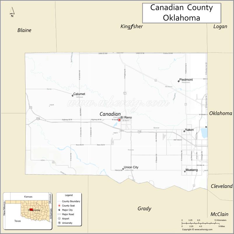
About Canadian County Map, Oklahoma: The map showing the county boundary, county seat, major cities, highways, water bodies and neighbouring counties.
Related Oklahoma Maps
About Canadian County, Oklahoma
Canadian County is a county located in the U.S. state of Oklahoma. It's county seat is El Reno. As per 2020 census, the population of Canadian County is 161737 people and population density is 179.71 square miles. According to the United States Census Bureau, the county has a total area of 900 sq mi (2,331 km2). Canadian County was established on 1901.
Canadian County Facts
| Continent | North America |
| Country | United States |
| State | Oklahoma |
| County Seat | El Reno |
| Largest City/Town | Yukon |
| Established | 1889 |
| Total Area | 906 sq mi (2,347 sq km) |
| Land Area | 897 sq mi (2,323 sq km) |
| Water Area | 9 sq mi (23 sq km) |
| Population | 154,405 (Census 2020) |
| Population Density | 172.1 people per sq mi |
| Time Zone | Central Time Zone (CST/CDT) |
| Major Highways | Interstate 40, Interstate 44 nearby region, U.S. Route 81, Historic Route 66 |
| Major Rivers | Canadian River, North Canadian River |
| Neighboring Counties | Oklahoma County, Kingfisher County, Blaine County, Caddo County, Grady County, Logan County |
| Famous For | Rapid suburban growth, Route 66 history, Yukon Czech heritage, and Oklahoma City metropolitan area |
| Top Attractions | Historic Route 66, Lake El Reno, Yukon Czech Festival, and Fort Reno Historic Site |
| Official Website | Official Website |
About Canadian County, Oklahoma
Canadian County is located in central Oklahoma within the Oklahoma City metropolitan region and was established during the Land Run of 1889. The county seat is El Reno, while Yukon is the largest city. The county is known for suburban communities, transportation corridors, agriculture, historic Route 66, and cultural festivals.
Cities and Towns in Canadian County, Oklahoma
| City/Town | Population (Census 2020) | Latitude & Longitude |
|---|---|---|
| Yukon | 24,630 | 35.5067°N, 97.7625°W |
| El Reno (county seat) | 16,699 | 35.5323°N, 97.9551°W |
| Mustang | 19,879 | 35.3842°N, 97.7245°W |
| Piedmont | 8,458 | 35.6425°N, 97.7464°W |
| Tuttle nearby region | 7,413 | 35.2906°N, 97.8120°W |
| Union City | 1,769 | 35.3926°N, 97.9412°W |
Golf Courses in Canadian County, Oklahoma
| Golf Course | Location | Latitude & Longitude |
|---|---|---|
| Crimson Creek Golf Course | El Reno | 35.5437°N, 97.9708°W |
| Surrey Hills Golf Club | Yukon nearby region | 35.5369°N, 97.8135°W |
| Mustang Creek Golf Area | Mustang | 35.3951°N, 97.7377°W |
Major Roads and Highways in Canadian County, Oklahoma
Major highways connect Canadian County with Oklahoma City, western Oklahoma, and the historic Route 66 corridor.
- Interstate 40 - major east-west interstate highway across Oklahoma
- Interstate 44 nearby region - important regional transportation corridor
- U.S. Route 81 - north-south highway serving agricultural and suburban communities
- Historic Route 66 - famous historic roadway through Yukon and El Reno
What are the Neighboring Counties of Canadian County
- Kingfisher County (north)
- Logan County (northeast)
- Oklahoma County (east)
- Grady County (south)
- Caddo County (west)
- Blaine County (northwest)
What are the Top Places to Visit in Canadian County, Oklahoma
The county offers Route 66 history, lakes, festivals, museums, and recreation opportunities.
- Historic Route 66 - classic roadside attractions and historic travel landmarks
- Fort Reno Historic Site - military history museum and preserved frontier fort
- Lake El Reno - boating, fishing, camping, and outdoor recreation
- Yukon Czech Festival - annual cultural celebration with music, food, and parades
- Historic Downtown El Reno - heritage architecture, restaurants, and local events
- Chisholm Trail Museum nearby region - western Oklahoma pioneer history
- Parks and Walking Trails - family recreation and outdoor activities
- Community Rodeos and Festivals - local traditions and entertainment
- Canadian River Scenic Areas - nature observation and photography opportunities
- Shopping and Dining in Yukon and Mustang - suburban entertainment and commerce
What is the Distance from Canadian County to Nearby Cities
The following distances are measured by road (driving).
- El Reno to Oklahoma City (Oklahoma County), Oklahoma - 29 mi (47 km)
- El Reno to Norman (Cleveland County), Oklahoma - 46 mi (74 km)
- El Reno to Stillwater (Payne County), Oklahoma - 74 mi (119 km)
- El Reno to Weatherford (Custer County), Oklahoma - 67 mi (108 km)
- El Reno to Yukon (Canadian County), Oklahoma - 13 mi (21 km)
- El Reno to Mustang (Canadian County), Oklahoma - 20 mi (32 km)
- El Reno to Tulsa (Tulsa County), Oklahoma - 128 mi (206 km)
- El Reno to Wichita (Sedgwick County), Kansas - 160 mi (257 km)
- El Reno to Dallas (Dallas County), Texas - 213 mi (343 km)
- El Reno to Amarillo (Potter County), Texas - 260 mi (418 km)
- El Reno to Kansas City (Jackson County), Missouri - 344 mi (554 km)
- El Reno to Denver (Denver County), Colorado - 545 mi (877 km)
- El Reno to Chicago (Cook County), Illinois - 793 mi (1,276 km)
FAQs about Canadian County
Canadian County is located in central Oklahoma within the Oklahoma City metropolitan area.
Canadian County had a population of 154,405 according to the 2020 United States Census.
Canadian County is known for Route 66 history, suburban growth, Yukon Czech heritage, and transportation corridors.
The county is served by Interstate 40, Interstate 44 nearby region, U.S. Route 81, and Historic Route 66.
Yes, Canadian County includes golf facilities such as Crimson Creek Golf Course and Surrey Hills Golf Club.
References
- QuickFacts - U.S. Census Bureau
- United States Census Bureau
- United States Geological Survey (USGS)
- National Geodetic Survey
- Official Website
- Adair County Map
- Alfalfa County Map
- Atoka County Map
- Beaver County Map
- Beckham County Map
- Blaine County Map
- Bryan County Map
- Caddo County Map
- Canadian County Map
- Carter County Map
- Cherokee County Map
- Choctaw County Map
- Cimarron County Map
- Cleveland County Map
- Coal County Map
- Comanche County Map
- Cotton County Map
- Craig County Map
- Creek County Map
- Custer County Map
- Delaware County Map
- Dewey County Map
- Ellis County Map
- Garfield County Map
- Garvin County Map
- Grady County Map
- Grant County Map
- Greer County Map
- Harmon County Map
- Harper County Map
- Haskell County Map
- Hughes County Map
- Jackson County Map
- Jefferson County Map
- Johnston County Map
- Kay County Map
- Kingfisher County Map
- Kiowa County Map
- Latimer County Map
- Le Flore County Map
- Lincoln County Map
- Logan County Map
- Love County Map
- McClain County Map
- McCurtain County Map
- McIntosh County Map
- Major County Map
- Marshall County Map
- Mayes County Map
- Murray County Map
- Muskogee County Map
- Noble County Map
- Nowata County Map
- Okfuskee County Map
- Oklahoma County Map
- Okmulgee County Map
- Osage County Map
- Ottawa County Map
- Pawnee County Map
- Payne County Map
- Pittsburg County Map
- Pontotoc County Map
- Pottawatomie County Map
- Pushmataha County Map
- Roger Mills County Map
- Rogers County Map
- Seminole County Map
- Sequoyah County Map
- Stephens County Map
- Texas County Map
- Tillman County Map
- Tulsa County Map
- Wagoner County Map
- Washington County Map
- Washita County Map
- Woods County Map
- Woodward County Map
- Alabama Counties
- Alaska boroughs
- Arizona Counties
- Arkansas Counties
- California County Map
- Colorado Counties
- Connecticut Counties
- Delaware Counties
- Florida County Map
- Georgia County Map
- Hawaii Counties
- Idaho Counties
- Illinois Counties
- Indiana Counties
- Iowa Counties
- Kansas Counties
- Kentucky Counties
- Louisiana Counties
- Maine Counties
- Maryland Counties
- Massachusetts Counties
- Michigan County Map
- Minnesota Counties
- Mississippi Counties
- Missouri Counties
- Montana Counties
- Nebraska Counties
- Nevada Counties
- New York Counties
- New Hampshire Counties
- New Jersey Counties
- New Mexico Counties
- North Carolina Counties
- North Dakota Counties
- Ohio County Map
- Oklahoma Counties
- Oregon Counties
- Pennsylvania Counties
- Rhode Island Counties
- South Carolina Counties
- South Dakota Counties
- Map of Tennessee
- Texas County Map
- Utah Counties
- Vermont Counties
- Virginia Counties
- Washington Counties
- West Virginia Counties
- Wisconsin Counties
- Wyoming Counties