
Where is Broken Arrow Located? - Broken Arrow is a city located in the Tulsa, Wagoner County of Oklahoma, United States. Broken Arrow lies between 35.99081 Degrees North latitudes and -95.8143 Degrees West longitudes.
Location Map of Broken Arrow, Oklahoma
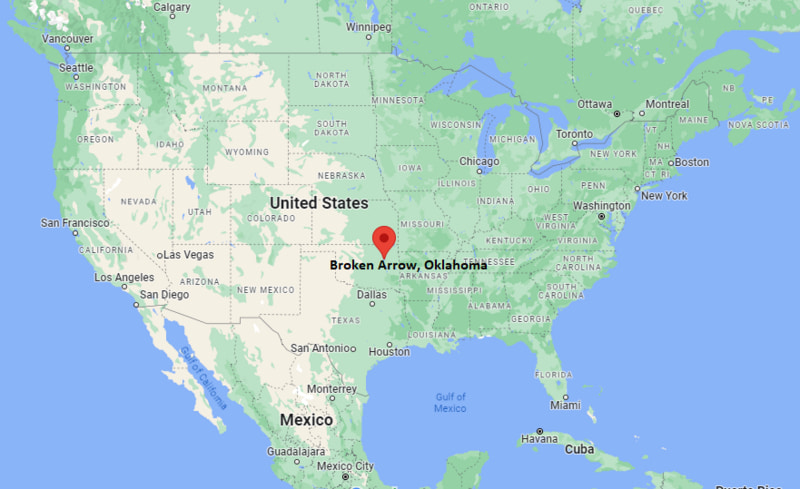
Broken Arrow Map, Oklahoma, USA
Where is Broken Arrow?: The Google Map showing the location of Broken Arrow in the U.S. state of Oklahoma.
Where is Broken Arrow Located?
Broken Arrow is a city located in the Tulsa County and Wagoner County of Oklahoma, United States. Broken Arrow lies between 35.99081 Degrees North latitude and -95.8143 Degrees West longitude. According to the 2020 U.S. Census, the population of Broken Arrow city is 113,540 people and the city has a total area of 63.03 sq mi. The city has numerous parks and recreational facilities.
Most Viewed US Maps
| USA Sttae Map | USA Region Map | USA Road Map |
| USA County Map | Where is USA in World Map? | US ZIP Code Map |
| USA Time Zones Map | US State and Capitals Map | USA Physical Map |
Find 4,400+ U.S. Cities by State - Explore Their Locations and Get Detailed Information
Broken Arrow, Oklahoma Quick Facts
| Fact | Details |
|---|---|
| City | Broken Arrow |
| County | Wagoner County / Tulsa County |
| State | Oklahoma |
| State Capital | Oklahoma City |
| Country | United States |
| US Region | South Central |
| Latitude | 35.99081 N |
| Longitude | -95.8143 W |
| Elevation | 699 ft (213 m) |
| Land Area | approximately 62.3 sq mi |
| Water Area | approximately 1.0 sq mi |
| Total Area | approximately 63.3 sq mi |
| Population (Census 2020) | 113,540 |
| Population Density | Approximately 1,820 per sq mi |
| ZIP Codes | 74011–74014 |
| Area Code | 539, 918 |
| Time Zone Standard | Central Standard Time (CST, UTC-6) |
| Time Zone Daylight | Central Daylight Time (CDT, UTC-5) |
| Currency | United States Dollar (USD) |
| FIPS Code | 40-09050 |
| Congressional District | Oklahoma's 1st Congressional District |
Nearby Cities and Towns to Broken Arrow, Oklahoma
- Tulsa, Oklahoma - 12 mi Northwest
- Owasso, Oklahoma - 20 mi North
- Bixby, Oklahoma - 10 mi West
- Coweta, Oklahoma - 12 mi Southeast
- Jenks, Oklahoma - 10 mi West
- Claremore, Oklahoma - 22 mi Northeast
- Collinsville, Oklahoma - 25 mi North
- Glenpool, Oklahoma - 15 mi Southwest
- Okmulgee, Oklahoma - 35 mi South
- Porter, Oklahoma - 18 mi East
Broken Arrow, Oklahoma Climate and Weather Overview
| Month | Avg High (°F) | Avg Low (°F) | Avg Precipitation (in) |
|---|---|---|---|
| January | 46 | 26 | 1.6 |
| April | 70 | 48 | 3.5 |
| July | 93 | 72 | 3.2 |
| October | 72 | 50 | 3.1 |
| Annual | 69 | 48 | 40.5 |
| Climate Attribute | Details |
|---|---|
| Climate Classification | Humid Subtropical (Köppen Cfa) |
| Annual Precipitation | Approximately 40.5 inches |
| Annual Snowfall | About 5–8 inches |
| Severe Weather Risk | High - thunderstorms, tornadoes, hail, strong winds |
| Annual Sunshine Days | About 230 days |
Driving Distances from Broken Arrow, Oklahoma
| City | State | Distance (mi) | Approx. Drive Time |
|---|---|---|---|
| Tulsa | Oklahoma | 12 | 20 min |
| Bixby | Oklahoma | 10 | 15 min |
| Jenks | Oklahoma | 10 | 15 min |
| Owasso | Oklahoma | 20 | 25 min |
| Coweta | Oklahoma | 12 | 18 min |
| Claremore | Oklahoma | 22 | 30 min |
| Glenpool | Oklahoma | 15 | 20 min |
| Sand Springs | Oklahoma | 20 | 25 min |
| Okmulgee | Oklahoma | 35 | 45 min |
| Muskogee | Oklahoma | 40 | 50 min |
Transportation and Connectivity in Broken Arrow, Oklahoma
| Transportation | Details |
|---|---|
| Nearest Airport | Tulsa International Airport |
| IATA Code | TUL |
| Nearest Major Airport | Tulsa International Airport |
| Major Highways | US-64, US-51, Creek Turnpike |
| Rail Service | Freight rail via BNSF Railway |
| Local Transit | Metropolitan Tulsa Transit (bus service) |
- US-64 is the main east–west corridor connecting Broken Arrow with Tulsa and Muskogee.
- Creek Turnpike provides fast access around the Tulsa metro area.
- Tulsa International Airport (TUL) is the primary air hub for the region.
- Metropolitan Tulsa Transit provides limited bus connectivity across the metro area.
Key Landmarks and Places to Visit in Broken Arrow, Oklahoma
| Landmark | Type |
|---|---|
| Rose District | Downtown Arts & Entertainment District |
| Broken Arrow Performing Arts Center | Performing Arts Venue |
| Ray Harral Nature Park | Nature Park |
| Military History Museum of Broken Arrow | Museum |
| Battle Creek Golf Club | Golf Course |
| MeadowBrook Country Club | Golf Course |
| New Orleans Square | Shopping & Dining Center |
| Central Park Community Center | Recreation Center |
| Haikey Creek Park (nearby) | Regional Park |
| Arkansas River Trails (nearby) | Recreation Trail System |
Colleges and Universities in Broken Arrow, Oklahoma
| Institution | Type | Level | Notable For |
|---|---|---|---|
| Rogers State University (nearby Claremore) | Public | University | Business, aviation, liberal arts, education |
| University of Tulsa | Private | Research University | Law, engineering, business, computer science |
| Oklahoma State University (Tulsa campus) | Public | University | Engineering, health sciences, business |
| Tulsa Community College | Public | Community College | Associate degrees and workforce training |
| Northeastern State University (Broken Arrow campus) | Public | University | Education, business, health professions |
| Oral Roberts University (Tulsa) | Private | University | Business, theology, communications |
Waterbodies in Broken Arrow, Oklahoma
Verdigris River (regional), Arkansas River, Haikey Creek, Joe Creek, Broken Arrow Creek, Lake Bixhoma (nearby), Skiatook Lake (regional), Keystone Lake, Liberty Lake, Zink Lake (Tulsa).
Golf Courses in Broken Arrow, Oklahoma
Battle Creek Golf Club, MeadowBrook Country Club, The Club at Forest Ridge, Golf Club of Oklahoma (nearby Owasso), Bailey Ranch Golf Club, LaFortune Park Golf Course (Tulsa), South Lakes Golf Course, Stone Creek Golf Club.
Broken Arrow, Oklahoma - Key Historical Facts
- Broken Arrow was founded by settlers from the Creek Nation in the late 19th century after relocation from Alabama.
- The city’s name is believed to come from a Creek settlement or a broken bow symbol used by Native American communities.
- It remained a small agricultural town for much of its early history.
- The arrival of the railroad in the early 1900s helped it grow as a trade and farming center.
- Suburban expansion from nearby Tulsa transformed Broken Arrow into a major residential city in the late 20th century.
- Today, it is one of Oklahoma’s largest cities, known for its family communities, Rose District, and strong local economy.
References
Oklahoma More Maps & Info
- Where is Ada
- Where is Altus
- Where is Ardmore
- Where is Bartlesville
- Where is Bethany
- Where is Bixby
- Where is Blanchard
- Where is Broken Arrow
- Where is Chickasha
- Where is Choctaw
- Where is Claremore
- Where is Collinsville
- Where is Coweta
- Where is Del City
- Where is Duncan
- Where is Durant
- Where is Edmond
- Where is El Reno
- Where is Elk City
- Where is Enid
- Where is Glenpool
- Where is Guthrie
- Where is Guymon
- Where is Jenks
- Where is Lawton
- Where is McAlester
- Where is Midwest City
- Where is Moore
- Where is Muskogee
- Where is Mustang
- Where is Newcastle
- Where is Norman
- Where is Okmulgee
- Where is Owasso
- Where is Ponca City
- Where is Poteau
- Where is Pryor Creek
- Where is Sand Springs
- Where is Sapulpa
- Where is Shawnee
- Where is Stillwater
- Where is Tahlequah
- Where is The Village
- Where is Warr Acres
- Where is Weatherford
- Where is Woodward
- Where is Yukon