
Where is Ephrata Located? - Ephrata is a city located in the Lancaster County of Pennsylvania, United States. Ephrata lies between 46.8891374 Degrees North latitudes and 97.0525872 Degrees West longitudes.
Location Map of Ephrata, Pennsylvania
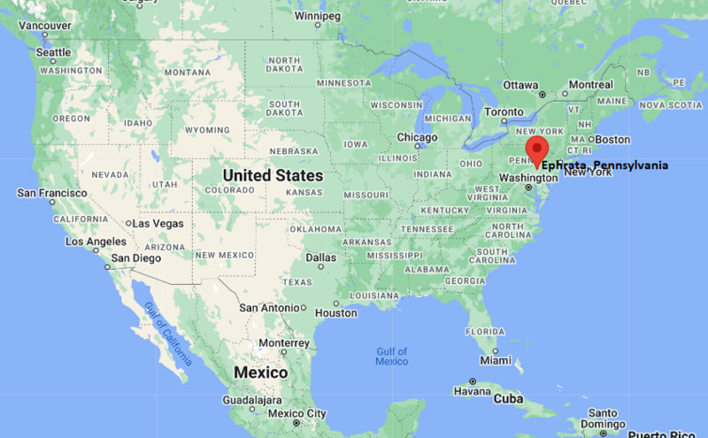
Ephrata Map, Pennsylvania, USA
Where is Ephrata?: The Google Map showing the location of Ephrata in the U.S. state of Pennsylvania.
Where is Ephrata Located?
Ephrata is a city located in the Lancaster County of Pennsylvania, United States. Ephrata lies between 46.8891374 Degrees North latitudes and 97.0525872 Degrees West longitudes. According to 2020 U.S.census, the population of Ephrata city is 13794 people and the city has a total area of 3.42 sq mi. The city has numerous parks and recreational facilities.
Most Viewed US Maps
| USA Sttae Map | USA Region Map | USA Road Map |
| USA County Map | Where is USA in World Map? | US ZIP Code Map |
| USA Time Zones Map | US State and Capitals Map | USA Physical Map |
Find 4,400+ U.S. Cities by State - Explore Their Locations and Get Detailed Information
Ephrata, Pennsylvania Quick Facts
| Property | Details |
|---|---|
| Borough | Ephrata |
| County | Lancaster County |
| State | Pennsylvania |
| State Capital | Harrisburg |
| US Region | Northeast |
| Latitude | 40.1798°N |
| Longitude | 76.1783°W |
| Elevation | 430 ft (131 m) |
| Land Area | 3.48 sq mi |
| Water Area | 0.03 sq mi |
| Total Area | 3.51 sq mi |
| Population (2020 Census) | 13,794 |
| Population Density | Approximately 3,965 per sq mi |
| ZIP Code | 17522 |
| Area Code | 717 |
| Time Zone Standard | Eastern Standard Time (EST), UTC−5 |
| Time Zone Daylight | Eastern Daylight Time (EDT), UTC−4 |
| Currency | US Dollar (USD) |
| FIPS Code | 42-22256 |
| Congressional District | Pennsylvania's 11th Congressional District |
Nearby Cities to Ephrata, Pennsylvania
- Akron, Pennsylvania - Southwest - 3 mi
- Lititz, Pennsylvania - West - 9 mi
- Denver, Pennsylvania - Northeast - 8 mi
- New Holland, Pennsylvania - Southeast - 9 mi
- Lancaster, Pennsylvania - South - 15 mi
- Reading, Pennsylvania - Northeast - 20 mi
- Lebanon, Pennsylvania - North - 23 mi
- Columbia, Pennsylvania - Southwest - 24 mi
- Harrisburg, Pennsylvania - Northwest - 39 mi
- York, Pennsylvania - Southwest - 42 mi
Ephrata, Pennsylvania Climate and Weather Overview
| Month | Avg High (°F) | Avg Low (°F) | Avg Rainfall (in) |
|---|---|---|---|
| January | 39 | 22 | 3.10 |
| April | 63 | 41 | 3.80 |
| July | 86 | 66 | 4.20 |
| October | 67 | 45 | 3.40 |
| Annual | 64 | 44 | 45.00 |
| Climate Attribute | Details |
|---|---|
| Climate Classification (Köppen) | Humid Continental (Dfa) |
| Annual Rainfall | Approximately 45 inches |
| Annual Sunshine Days | About 203 days |
| Hurricane/Tornado Risk | Low hurricane risk; low tornado risk |
| Snowfall | Approximately 22 inches annually |
Driving Distances from Ephrata, Pennsylvania
| City | State | Distance (mi) | Approx. Drive Time |
|---|---|---|---|
| Akron | Pennsylvania | 3 | 7 min |
| Denver | Pennsylvania | 8 | 12 min |
| Lititz | Pennsylvania | 9 | 15 min |
| New Holland | Pennsylvania | 9 | 15 min |
| Lancaster | Pennsylvania | 15 | 25 min |
| Reading | Pennsylvania | 20 | 30 min |
| Lebanon | Pennsylvania | 23 | 35 min |
| Columbia | Pennsylvania | 24 | 35 min |
| Harrisburg | Pennsylvania | 39 | 50 min |
| York | Pennsylvania | 42 | 55 min |
Transportation and Connectivity in Ephrata, Pennsylvania
| Transportation | Details |
|---|---|
| Airport Name | Lancaster Airport |
| IATA Code | LNS |
| Port | None |
| Major Highways | U.S. Route 222, Pennsylvania Route 272, Pennsylvania Route 322 |
| Train/Amtrak Service | Nearest Amtrak station is Lancaster Station |
| Local Bus/Transit Service | Red Rose Transit Authority (RRTA) |
- U.S. Route 222 provides direct access to Reading, Lancaster, and the Pennsylvania Turnpike.
- Pennsylvania Routes 272 and 322 connect Ephrata with neighboring Lancaster County communities.
- Lancaster Airport, approximately 11 miles south, offers regional air service and general aviation facilities.
- Red Rose Transit Authority (RRTA) operates bus routes linking Ephrata with Lancaster and nearby towns.
Places to Visit in Ephrata, Pennsylvania
| Landmark Name | Type |
|---|---|
| Ephrata Cloister | Historic Site & Museum |
| Linear Park | Community Park |
| Thomas P. Grater Community Park | Recreation Park |
| Heatherwood Bike Park | Bicycle Park |
| Middle Creek Wildlife Management Area | Wildlife Reserve |
| Lititz Springs Park | Public Park |
| Wolf Sanctuary of PA | Wildlife Sanctuary |
| Lancaster Central Market | Historic Market |
| Landis Valley Village & Farm Museum | Living History Museum |
| Kitchen Kettle Village | Shopping & Cultural Village |
Colleges and Universities in Ephrata, Pennsylvania
| Institution Name | Type | Level | Notable For |
|---|---|---|---|
| Penn State Harrisburg | Public | University | Engineering, business, and research |
| Franklin & Marshall College | Private | College | Liberal arts education |
| Millersville University | Public | University | Education and business programs |
| Thaddeus Stevens College of Technology | Public | Technical College | Skilled trades and technical education |
| Lancaster Bible College | Private | College | Biblical studies and ministry |
| Penn State Berks | Public | University Campus | Undergraduate education |
| Albright College | Private | College | Liberal arts and sciences |
| Ephrata Area School District | Public | K–12 District | Primary and secondary education |
Waterbodies in Ephrata, Pennsylvania
Cocalico Creek, Muddy Creek, Middle Creek, Hammer Creek, Speedwell Lake, Middle Creek Reservoir, Conestoga River, Susquehanna River
Golf Courses in Ephrata, Pennsylvania
Foxchase Golf Club, Fairview Golf Course, Iron Valley Golf Club, Overlook Golf Course, Crossgates Golf Club, Highlands of Donegal Golf Club, Galen Hall Golf Club, Berkleigh Golf Club
Ephrata, Pennsylvania — Key Historical Facts
- Ephrata was founded in the early 18th century and became famous for the establishment of the Ephrata Cloister in 1732 by German religious leader Johann Conrad Beissel.
- The Ephrata Cloister grew into one of colonial America's most significant religious communities, known for its distinctive architecture, music, printing, and education.
- During the 18th and 19th centuries, the borough developed as a regional center for farming, milling, and commerce in Lancaster County.
- The arrival of the Reading and Columbia Railroad in the 19th century encouraged industrial growth and improved trade throughout the region.
- Ephrata has carefully preserved many of its historic buildings while expanding residential neighborhoods, local businesses, and recreational facilities.
- Today, the borough is known for its rich colonial heritage, thriving downtown, parks, and convenient location within Pennsylvania Dutch Country.
References
- Borough of Ephrata
- U.S. Census Bureau
- Pennsylvania Historical & Museum Commission
- Discover Lancaster
Pennsylvania More Maps & Info
- Where is Allentown
- Where is Allison Park
- Where is Altoona
- Where is Baldwin
- Where is Bethel Park
- Where is Bethlehem
- Where is Carlisle
- Where is Chambersburg
- Where is Chester
- Where is Colonial Park
- Where is Drexel Hill
- Where is Dunmore
- Where is Easton
- Where is Ephrata
- Where is Erie
- Where is Franklin Park
- Where is Fullerton
- Where is Greensburg
- Where is Hanover
- Where is Harrisburg
- Where is Hazleton
- Where is Hermitage
- Where is Horsham
- Where is Indiana
- Where is Johnstown
- Where is King of Prussia
- Where is Lancaster
- Where is Lansdale
- Where is Lebanon
- Where is Levittown
- Where is McKeesport
- Where is Monroeville
- Where is Murrysville
- Where is New Castle
- Where is Norristown
- Where is Phoenixville
- Where is Plum
- Where is Pottstown
- Where is Reading
- Where is Scranton
- Where is State College
- Where is Weigelstown
- Where is West Chester
- Where is West Mifflin
- Where is Whitehall
- Where is Wilkes-Barre
- Where is Williamsport
- Where is York