
Where is King of Prussia Located? - King of Prussia is a city located in the Montgomery County of Pennsylvania, United States. King of Prussia lies between 46.8266603 Degrees North latitudes and 100.8895761 Degrees West longitudes.
Location Map of King of Prussia, Pennsylvania
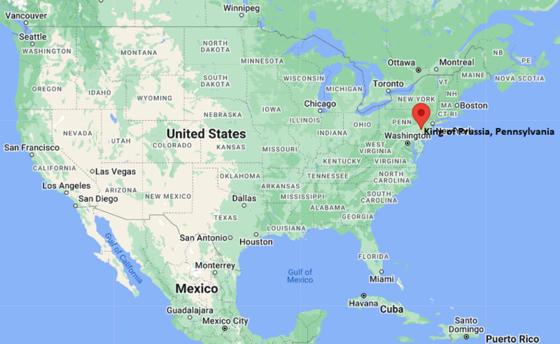
King of Prussia Map, Pennsylvania, USA
Where is King of Prussia?: The Google Map showing the location of King of Prussia in the U.S. state of Pennsylvania.
Where is King of Prussia Located?
King of Prussia is a city located in the Montgomery County of Pennsylvania, United States. King of Prussia lies between 46.8266603 Degrees North latitudes and 100.8895761 Degrees West longitudes. According to 2020 U.S.census, the population of King of Prussia city is 24695 people and the city has a total area of 8.49 sq mi. The city has numerous parks and recreational facilities.
Most Viewed US Maps
| USA Sttae Map | USA Region Map | USA Road Map |
| USA County Map | Where is USA in World Map? | US ZIP Code Map |
| USA Time Zones Map | US State and Capitals Map | USA Physical Map |
Find 4,400+ U.S. Cities by State - Explore Their Locations and Get Detailed Information
King of Prussia, Pennsylvania Quick Facts
| Property | Information |
|---|---|
| Community | King of Prussia (Census-Designated Place) |
| County | Montgomery County |
| State | Pennsylvania |
| State Capital | Harrisburg |
| US Region | Northeastern United States |
| Latitude | 40.1013° N |
| Longitude | 75.3836° W |
| Elevation | 200 ft (61 m) |
| Land Area | 8.57 sq mi |
| Water Area | 0.03 sq mi |
| Total Area | 8.60 sq mi |
| Population (Latest Census Year) | 24,695 (2020 Census) |
| Population Density | Approximately 2,882 per sq mi |
| ZIP Code(s) | 19406 |
| Area Code(s) | 610, 484, 835 |
| Time Zone Standard | Eastern Standard Time (EST, UTC−5) |
| Time Zone Daylight | Eastern Daylight Time (EDT, UTC−4) |
| Currency | U.S. Dollar (USD) |
| FIPS Code | 42-39920 |
| Congressional District | Pennsylvania's 4th Congressional District |
Nearby Cities to King of Prussia, Pennsylvania
- Bridgeport, Pennsylvania - East - 2 mi
- Norristown, Pennsylvania - Northeast - 4 mi
- Conshohocken, Pennsylvania - East - 7 mi
- Wayne, Pennsylvania - South - 4 mi
- Phoenixville, Pennsylvania - Northwest - 8 mi
- Plymouth Meeting, Pennsylvania - East - 8 mi
- Collegeville, Pennsylvania - Northwest - 10 mi
- West Chester, Pennsylvania - Southwest - 18 mi
- Philadelphia, Pennsylvania - Southeast - 20 mi
- Pottstown, Pennsylvania - Northwest - 24 mi
Driving Distances from King of Prussia, Pennsylvania
| City | State | Distance (mi) | Approx. Drive Time |
|---|---|---|---|
| Bridgeport | Pennsylvania | 2 | 5 minutes |
| Wayne | Pennsylvania | 4 | 10 minutes |
| Norristown | Pennsylvania | 4 | 10 minutes |
| Conshohocken | Pennsylvania | 7 | 15 minutes |
| Phoenixville | Pennsylvania | 8 | 15 minutes |
| Plymouth Meeting | Pennsylvania | 8 | 15 minutes |
| Collegeville | Pennsylvania | 10 | 20 minutes |
| West Chester | Pennsylvania | 18 | 30 minutes |
| Philadelphia | Pennsylvania | 20 | 35 minutes |
| Pottstown | Pennsylvania | 24 | 35 minutes |
Transportation and Connectivity in King of Prussia, Pennsylvania
| Transportation | Details |
|---|---|
| Airport Name | Philadelphia International Airport |
| IATA Code | PHL |
| Port | Port of Philadelphia |
| Major Highways | Interstate 76, Interstate 276 (Pennsylvania Turnpike), U.S. Route 202, U.S. Route 422 |
| Train Service | Nearby SEPTA Regional Rail stations at Norristown, Bridgeport, and Wayne |
| Local Transit | SEPTA Bus Routes and the King of Prussia Transit Center |
- Philadelphia International Airport is approximately 25 miles southeast of King of Prussia.
- Interstates 76 and 276 provide direct access to Philadelphia, Harrisburg, New Jersey, and the Pennsylvania Turnpike.
- U.S. Routes 202 and 422 make King of Prussia one of the region's busiest transportation hubs.
- SEPTA buses connect the community with Norristown, Philadelphia, and neighboring suburbs.
- The community's central location makes it a major commercial, retail, and business destination in southeastern Pennsylvania.
What are top Places to Visit in King of Prussia, Pennsylvania
| Landmark Name | Type |
|---|---|
| King of Prussia Mall | Shopping Mall |
| Valley Forge National Historical Park | National Historical Park |
| Valley Forge Casino Resort | Casino & Resort |
| Topgolf King of Prussia | Entertainment Venue |
| iFLY King of Prussia | Indoor Skydiving Center |
| Valley Forge Audubon Society | Nature Center |
| Heuser Park | Community Park |
| McKaig Nature Education Center | Nature Preserve |
| Escape Game King of Prussia | Entertainment Attraction |
| Historic Valley Forge Area | Historic Landmark |
Colleges and Universities in King of Prussia, Pennsylvania
| Institution Name | Type | Level | Notable For |
|---|---|---|---|
| Penn State Great Valley | Public | University | Graduate and professional education |
| Cabrini University Campus | Private | University | Former liberal arts campus |
| Villanova University | Private | University | Research and business programs |
| Valley Forge Military College | Private | College | Military and leadership education |
| Upper Merion Area School District | Public | K–12 District | Public education serving King of Prussia |
Waterbodies in King of Prussia, Pennsylvania
Schuylkill River, Valley Creek, Trout Creek, Gulph Creek, Crow Creek, Crabby Creek, Black Rock Sanctuary Pond, Sullivan's Bridge Waterway
Stadiums in King of Prussia
Gulph Mills Golf Club, Jeffersonville Golf Club, The Club at Shannondell, Valley Forge Military Academy Stadium, Heuser Park Athletic Fields
King of Prussia, Pennsylvania — Key Historical Facts
- King of Prussia takes its name from a historic 18th-century tavern that was named in honor of King Frederick II of Prussia.
- The community is located adjacent to Valley Forge, where General George Washington and the Continental Army spent the winter of 1777–1778 during the American Revolutionary War.
- The opening of the King of Prussia Mall in the 1960s transformed the area into one of the nation's premier shopping destinations.
- Excellent highway access, including Interstate 76 and the Pennsylvania Turnpike, fueled rapid commercial and business development throughout the late 20th century.
- Today, King of Prussia is recognized as one of the Philadelphia region's leading retail, office, and hospitality centers while remaining closely connected to the area's Revolutionary War heritage.
References
- Upper Merion Township
- U.S. Census Bureau
- Penn State Great Valley
- Valley Forge National Historical Park
- Valley Forge Tourism & Convention Board
Pennsylvania More Maps & Info
- Where is Allentown
- Where is Allison Park
- Where is Altoona
- Where is Baldwin
- Where is Bethel Park
- Where is Bethlehem
- Where is Carlisle
- Where is Chambersburg
- Where is Chester
- Where is Colonial Park
- Where is Drexel Hill
- Where is Dunmore
- Where is Easton
- Where is Ephrata
- Where is Erie
- Where is Franklin Park
- Where is Fullerton
- Where is Greensburg
- Where is Hanover
- Where is Harrisburg
- Where is Hazleton
- Where is Hermitage
- Where is Horsham
- Where is Indiana
- Where is Johnstown
- Where is King of Prussia
- Where is Lancaster
- Where is Lansdale
- Where is Lebanon
- Where is Levittown
- Where is McKeesport
- Where is Monroeville
- Where is Murrysville
- Where is New Castle
- Where is Norristown
- Where is Phoenixville
- Where is Plum
- Where is Pottstown
- Where is Reading
- Where is Scranton
- Where is State College
- Where is Weigelstown
- Where is West Chester
- Where is West Mifflin
- Where is Whitehall
- Where is Wilkes-Barre
- Where is Williamsport
- Where is York