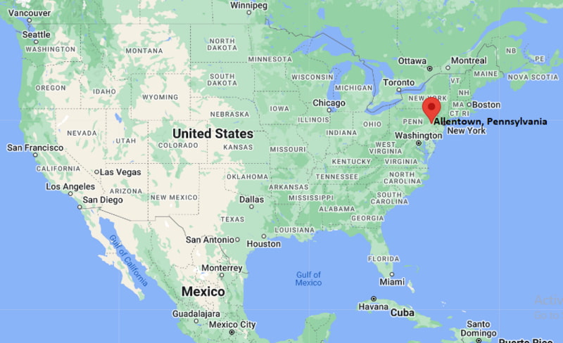
Where is Allentown Located? - Allentown is a city located in the Lehigh County of Pennsylvania, United States. Allentown lies between 39.9945084 Degrees North latitudes and 83.0624078 Degrees West longitudes.
Location Map of Allentown, Pennsylvania

Allentown Map, Pennsylvania, USA
Where is Allentown?: The Google Map showing the location of Allentown in the U.S. state of Pennsylvania.
Where is Allentown Located?
Allentown is a city located in the Lehigh County of Pennsylvania, United States. Allentown lies between 39.9945084 Degrees North latitudes and 83.0624078 Degrees West longitudes. According to 2020 U.S.census, the population of Allentown city is 125845 people and the city has a total area of 17.55 sq mi. The city has numerous parks and recreational facilities.
Most Viewed US Maps
Allentown City Facts, Pennsylvania
| City Name | Allentown |
| County | Lehigh County |
| State | Pennsylvania |
| Country | United States |
| U.S. Region | Middle Atlantic |
| Coordinates | 40.6022939° N, 75.4714098° W |
| Latitude | 40.6022939 |
| Longitude | -75.4714098 |
| Population (2020 Census) | 125845 |
| Population Density (Sq mi) | 7305 |
| Area (Sq mi) | 17.55 |
| Currency | US Dollar, $ (USD) |
| Time Zone | Eastern Time - UTC?05:00 (Standard), UTC?04:00 (DST) | Places to Visit in Allentown | Trexler Memorial Park,America On Wheels Museum,Nockamixon State Park,Coca-Cola Park,J. Birney Crum Stadium | Nearest Airport | Lehigh Valley International Airport (ABE / KABE) |
Pennsylvania More Maps & Info
- Where is Allentown
- Where is Allison Park
- Where is Altoona
- Where is Baldwin
- Where is Bethel Park
- Where is Bethlehem
- Where is Carlisle
- Where is Chambersburg
- Where is Chester
- Where is Colonial Park
- Where is Drexel Hill
- Where is Dunmore
- Where is Easton
- Where is Ephrata
- Where is Erie
- Where is Franklin Park
- Where is Fullerton
- Where is Greensburg
- Where is Hanover
- Where is Harrisburg
- Where is Hazleton
- Where is Hermitage
- Where is Horsham
- Where is Indiana
- Where is Johnstown
- Where is King of Prussia
- Where is Lancaster
- Where is Lansdale
- Where is Lebanon
- Where is Levittown
- Where is McKeesport
- Where is Monroeville
- Where is Murrysville
- Where is New Castle
- Where is Norristown
- Where is Phoenixville
- Where is Plum
- Where is Pottstown
- Where is Reading
- Where is Scranton
- Where is State College
- Where is Weigelstown
- Where is West Chester
- Where is West Mifflin
- Where is Whitehall
- Where is Wilkes-Barre
- Where is Williamsport
- Where is York
