
Where is Horsham Located? - Horsham is a city located in the Montgomery County of Pennsylvania, United States. Horsham lies between 47.4980408 Degrees North latitudes and 97.3245354 Degrees West longitudes.
Location Map of Horsham, Pennsylvania
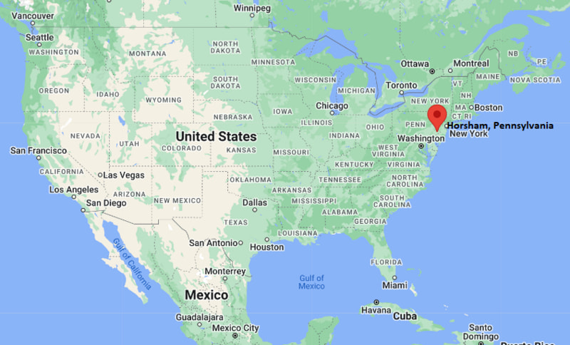
Horsham Map, Pennsylvania, USA
Where is Horsham?: The Google Map showing the location of Horsham in the U.S. state of Pennsylvania.
Where is Horsham Located?
Horsham is a city located in the Montgomery County of Pennsylvania, United States. Horsham lies between 47.4980408 Degrees North latitudes and 97.3245354 Degrees West longitudes. According to 2020 U.S.census, the population of Horsham city is 15193 people and the city has a total area of 5.47 sq mi. The city has numerous parks and recreational facilities.
Most Viewed US Maps
| USA Sttae Map | USA Region Map | USA Road Map |
| USA County Map | Where is USA in World Map? | US ZIP Code Map |
| USA Time Zones Map | US State and Capitals Map | USA Physical Map |
Find 4,400+ U.S. Cities by State - Explore Their Locations and Get Detailed Information
Horsham, Pennsylvania Quick Facts
| Property | Information |
|---|---|
| Township / Census-Designated Place | Horsham |
| County | Montgomery County |
| State | Pennsylvania |
| State Capital | Harrisburg |
| US Region | Northeastern United States |
| Latitude | 40.1784° N |
| Longitude | 75.1288° W |
| Elevation | 243 ft (74 m) |
| Land Area | 5.47 sq mi |
| Water Area | 0.00 sq mi |
| Total Area | 5.47 sq mi |
| Population (latest Census year) | 15,193 (2020 Census) |
| Population Density | Approximately 2,778 per sq mi |
| ZIP Codes | 19044 |
| Area Code | 215, 267, 445 |
| Time Zone Standard | Eastern Standard Time (EST, UTC−5) |
| Time Zone Daylight | Eastern Daylight Time (EDT, UTC−4) |
| Currency | US Dollar (USD) |
| FIPS Code | 42-35800 |
| Congressional District | Pennsylvania's 4th Congressional District |
Nearby Cities to Horsham, Pennsylvania
- Willow Grove, Pennsylvania - South - 3 mi
- Hatboro, Pennsylvania - East - 2 mi
- Ambler, Pennsylvania - West - 5 mi
- Warminster, Pennsylvania - Northeast - 5 mi
- Abington, Pennsylvania - South - 6 mi
- Fort Washington, Pennsylvania - Southwest - 7 mi
- Doylestown, Pennsylvania - North - 16 mi
- Norristown, Pennsylvania - West - 15 mi
- Philadelphia, Pennsylvania - South - 20 mi
- Trenton, New Jersey - Northeast - 28 mi
Driving Distances from Horsham, Pennsylvania
| City | State | Distance (mi) | Approx. Drive Time |
|---|---|---|---|
| Hatboro | Pennsylvania | 2 | 5 minutes |
| Willow Grove | Pennsylvania | 3 | 8 minutes |
| Ambler | Pennsylvania | 5 | 10 minutes |
| Warminster | Pennsylvania | 5 | 10 minutes |
| Abington | Pennsylvania | 6 | 15 minutes |
| Fort Washington | Pennsylvania | 7 | 15 minutes |
| Norristown | Pennsylvania | 15 | 25 minutes |
| Doylestown | Pennsylvania | 16 | 25 minutes |
| Philadelphia | Pennsylvania | 20 | 35 minutes |
| Trenton | New Jersey | 28 | 40 minutes |
Transportation and Connectivity in Horsham, Pennsylvania
| Transportation | Details |
|---|---|
| Airport Name | Philadelphia International Airport |
| IATA Code | PHL |
| Port | Port of Philadelphia |
| Major Highways | Pennsylvania Route 611, Pennsylvania Route 463, Pennsylvania Turnpike (I-276), Interstate 476 (nearby) |
| Train/Amtrak Service | SEPTA Regional Rail (Hatboro Station); Amtrak available at Philadelphia 30th Street Station |
| Local Bus/Transit Service | SEPTA Bus and Regional Rail services |
- Pennsylvania Route 611 is the primary north-south highway connecting Horsham with Philadelphia and Doylestown.
- Pennsylvania Route 463 links Horsham with Montgomery and Bucks County communities.
- The Pennsylvania Turnpike (Interstate 276) provides regional access across eastern Pennsylvania and neighboring states.
- Interstate 476 (Northeast Extension) connects the area with the Lehigh Valley and the Philadelphia metropolitan region.
- Nearby SEPTA Regional Rail stations and Philadelphia International Airport provide convenient commuter and long-distance travel options.
What are top Places to Visit in Horsham, Pennsylvania
| Landmark Name | Type |
|---|---|
| Graeme Park | Historic Site |
| Power Line Trail | Recreation Trail |
| Lukens Park | Community Park |
| Kohler Park | Community Park |
| Harold F. Pitcairn Wings of Freedom Aviation Museum | Aviation Museum |
| Merrymead Farm | Family Attraction |
| Elmwood Park Zoo | Zoo |
| Morris Arboretum | Botanical Garden |
| Valley Forge National Historical Park | National Historical Park |
| Pennypack Ecological Restoration Trust | Nature Preserve |
Colleges and Universities in Horsham, Pennsylvania
| Institution Name | Type | Level | Notable For |
|---|---|---|---|
| Gwynedd Mercy University | Private | University | Nursing, education, and business programs |
| Montgomery County Community College | Public | Community College | Associate degrees and workforce education |
| Arcadia University | Private | University | Liberal arts, healthcare, and international education |
| Temple University Ambler | Public | University | Horticulture, environmental sciences, and landscape architecture |
| Hatboro-Horsham School District | Public | K–12 District | Primary and secondary public education |
Waterbodies in Horsham, Pennsylvania
Pennypack Creek, Park Creek, Neshaminy Creek, Wissahickon Creek, Delaware River, Deep Meadow Run, Keith Valley Run, Twin Lakes
Golf Courses in Horsham, Pennsylvania
Commonwealth National Golf Club, Talamore Country Club, LuLu Country Club, Five Ponds Golf Club, Huntingdon Valley Country Club, Manufacturers' Golf & Country Club
Horsham, Pennsylvania — Key Historical Facts
- Horsham Township was established in 1717 and was named after the market town of Horsham in West Sussex, England.
- The area developed as an agricultural community during the eighteenth century before expanding through commerce and transportation improvements.
- Graeme Park, home to the historic Keith House built in 1722, remains one of Pennsylvania's best-preserved colonial estates.
- The establishment of the Naval Air Station Joint Reserve Base Willow Grove nearby contributed significantly to regional economic and residential growth throughout the twentieth century.
- Today, Horsham is recognized for its historic landmarks, thriving business community, quality schools, and convenient location within the Philadelphia metropolitan area.
References
- Horsham Township
- U.S. Census Bureau
- Montgomery County Community College
- Pennsylvania Historical and Museum Commission
Pennsylvania More Maps & Info
- Where is Allentown
- Where is Allison Park
- Where is Altoona
- Where is Baldwin
- Where is Bethel Park
- Where is Bethlehem
- Where is Carlisle
- Where is Chambersburg
- Where is Chester
- Where is Colonial Park
- Where is Drexel Hill
- Where is Dunmore
- Where is Easton
- Where is Ephrata
- Where is Erie
- Where is Franklin Park
- Where is Fullerton
- Where is Greensburg
- Where is Hanover
- Where is Harrisburg
- Where is Hazleton
- Where is Hermitage
- Where is Horsham
- Where is Indiana
- Where is Johnstown
- Where is King of Prussia
- Where is Lancaster
- Where is Lansdale
- Where is Lebanon
- Where is Levittown
- Where is McKeesport
- Where is Monroeville
- Where is Murrysville
- Where is New Castle
- Where is Norristown
- Where is Phoenixville
- Where is Plum
- Where is Pottstown
- Where is Reading
- Where is Scranton
- Where is State College
- Where is Weigelstown
- Where is West Chester
- Where is West Mifflin
- Where is Whitehall
- Where is Wilkes-Barre
- Where is Williamsport
- Where is York