
Where is Drexel Hill Located? - Drexel Hill is a city located in the Delaware County of Pennsylvania, United States. Drexel Hill lies between 46.8054947 Degrees North latitudes and 100.7876931 Degrees West longitudes.
Location Map of Drexel Hill, Pennsylvania
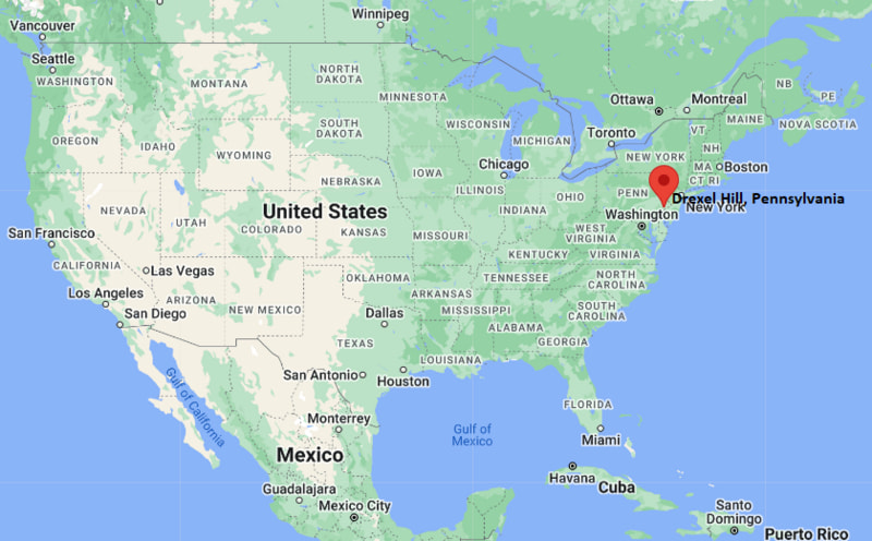
Drexel Hill Map, Pennsylvania, USA
Where is Drexel Hill?: The Google Map showing the location of Drexel Hill in the U.S. state of Pennsylvania.
Where is Drexel Hill Located?
Drexel Hill is a city located in the Delaware County of Pennsylvania, United States. Drexel Hill lies between 46.8054947 Degrees North latitudes and 100.7876931 Degrees West longitudes. According to 2020 U.S.census, the population of Drexel Hill city is 29181 people and the city has a total area of 3.2 sq mi. The city has numerous parks and recreational facilities.
Most Viewed US Maps
| USA Sttae Map | USA Region Map | USA Road Map |
| USA County Map | Where is USA in World Map? | US ZIP Code Map |
| USA Time Zones Map | US State and Capitals Map | USA Physical Map |
Find 4,400+ U.S. Cities by State - Explore Their Locations and Get Detailed Information
Drexel Hill, Pennsylvania Quick Facts
| Property | Details |
|---|---|
| Community | Drexel Hill (Census-Designated Place) |
| County | Delaware County |
| State | Pennsylvania |
| State Capital | Harrisburg |
| US Region | Northeastern United States (Mid-Atlantic) |
| Latitude | 39.9470°N |
| Longitude | 75.2926°W |
| Elevation | 282 ft (86 m) |
| Land Area | 3.19 sq mi |
| Water Area | 0.00 sq mi |
| Total Area | 3.19 sq mi |
| Population (2020 Census) | 29,181 |
| Population Density | About 9,150 per sq mi |
| ZIP Code | 19026 |
| Area Code | 484, 610 |
| Time Zone Standard | Eastern Standard Time (EST), UTC -5 |
| Time Zone Daylight | Eastern Daylight Time (EDT), UTC -4 |
| Currency | United States Dollar (USD) |
| FIPS Code | 42-19776 |
| Congressional District | Pennsylvania's 5th Congressional District |
Nearby Cities to Drexel Hill, Pennsylvania
- Upper Darby, Pennsylvania - Northeast - 2 mi
- Lansdowne, Pennsylvania - East - 2 mi
- Clifton Heights, Pennsylvania - South - 2 mi
- Yeadon, Pennsylvania - East - 3 mi
- Springfield, Pennsylvania - Southwest - 4 mi
- Philadelphia, Pennsylvania - East - 7 mi
- Media, Pennsylvania - Southwest - 8 mi
- Chester, Pennsylvania - South - 10 mi
- King of Prussia, Pennsylvania - Northwest - 17 mi
- Wilmington, Delaware - Southwest - 25 mi
Drexel Hill, Pennsylvania Climate and Weather Overview
| Month | Avg High (°F) | Avg Low (°F) | Avg Rainfall (in) |
|---|---|---|---|
| January | 41 | 25 | 3.3 |
| April | 64 | 43 | 3.8 |
| July | 87 | 69 | 4.5 |
| October | 67 | 47 | 3.4 |
| Annual | 65 | 46 | 47.5 |
| Climate Attribute | Details |
|---|---|
| Climate Classification (Köppen) | Humid Subtropical (Cfa) |
| Annual Rainfall | About 47.5 inches |
| Annual Sunshine Days | Approximately 207 days |
| Hurricane/Tornado Risk | Low hurricane risk; low tornado risk |
| Snowfall | About 23 inches annually |
Driving Distances from Drexel Hill, Pennsylvania
| City | State | Distance (mi) | Approx. Drive Time |
|---|---|---|---|
| Upper Darby | Pennsylvania | 2 | 6 min |
| Lansdowne | Pennsylvania | 2 | 7 min |
| Clifton Heights | Pennsylvania | 2 | 7 min |
| Yeadon | Pennsylvania | 3 | 10 min |
| Springfield | Pennsylvania | 4 | 10 min |
| Philadelphia | Pennsylvania | 7 | 20 min |
| Media | Pennsylvania | 8 | 18 min |
| Chester | Pennsylvania | 10 | 22 min |
| King of Prussia | Pennsylvania | 17 | 30 min |
| Wilmington | Delaware | 25 | 35 min |
Transportation and Connectivity in Drexel Hill, Pennsylvania
| Transportation | Details |
|---|---|
| Airport Name | Philadelphia International Airport |
| IATA Code | PHL |
| Port | Port of Philadelphia (regional access) |
| Major Highways | Pennsylvania Route 3 (West Chester Pike), Township Line Road, Interstate 476 (nearby) |
| Train/Passenger Rail | SEPTA Media–Sharon Hill Trolley and nearby Regional Rail |
| Local Bus/Transit Service | SEPTA Bus and Trolley |
- Pennsylvania Route 3 and nearby Interstate 476 provide convenient access to Philadelphia, King of Prussia, and surrounding suburbs.
- SEPTA's Route 101 trolley and multiple bus routes connect Drexel Hill with Center City Philadelphia and neighboring Delaware County communities.
- Nearby SEPTA Regional Rail stations offer commuter rail service throughout the Philadelphia metropolitan area.
- Philadelphia International Airport is approximately 9 miles southeast and provides extensive domestic and international flight connections.
Key Landmarks and Places to Visit in Drexel Hill, Pennsylvania
| Landmark Name | Type |
|---|---|
| Swarthmore College Scott Arboretum | Arboretum |
| Swedish Cabin | Historic Landmark |
| Naylor's Run Park | Community Park |
| Kent Park | Recreation Park |
| Lower Swedish Cabin | Historic Site |
| Tower Theater | Concert Venue |
| Bartram's Garden | Historic Botanical Garden |
| John Heinz National Wildlife Refuge at Tinicum | National Wildlife Refuge |
| Please Touch Museum | Children's Museum |
| Fairmount Park | Urban Park |
Colleges and Universities in Drexel Hill, Pennsylvania
| Institution | Type | Level | Notable For |
|---|---|---|---|
| Delaware County Community College | Public | Community College | Career education, transfer programs, and workforce training |
| Saint Joseph's University | Private | University | Business, healthcare, education, and liberal arts |
| Drexel University | Private | University | Engineering, cooperative education, and research |
| University of Pennsylvania | Private | University | Medicine, business, law, and research |
| Swarthmore College | Private | Liberal Arts College | Liberal arts and undergraduate research |
Waterbodies in Drexel Hill, Pennsylvania
Cobbs Creek, Darby Creek, Muckinipattis Creek, Schuylkill River, Delaware River, Ridley Creek, Crum Creek, Springton Lake.
Golf Courses in Drexel Hill, Pennsylvania
Springfield Country Club, Llanerch Country Club, Aronimink Golf Club, Cobbs Creek Golf Course, Rolling Green Golf Club, Paxon Hollow Country Club.
Drexel Hill, Pennsylvania - Key Historical Facts
- Drexel Hill developed during the late 19th and early 20th centuries as a suburban residential community west of Philadelphia.
- The community was named after the prominent Drexel family, whose influence extended across banking, philanthropy, and regional development in Pennsylvania.
- The extension of trolley lines in the early 1900s encouraged rapid residential growth, making Drexel Hill a popular commuter suburb.
- Historic sites such as the Swedish Cabin, believed to date from the late 1600s, reflect some of the earliest European settlement in the Delaware Valley.
- Throughout the 20th century, Drexel Hill evolved into one of Delaware County's largest residential communities while maintaining its suburban character.
- Today, Drexel Hill is known for its historic neighborhoods, convenient access to Philadelphia, strong public transportation network, parks, schools, and diverse local businesses.
References
Pennsylvania More Maps & Info
- Where is Allentown
- Where is Allison Park
- Where is Altoona
- Where is Baldwin
- Where is Bethel Park
- Where is Bethlehem
- Where is Carlisle
- Where is Chambersburg
- Where is Chester
- Where is Colonial Park
- Where is Drexel Hill
- Where is Dunmore
- Where is Easton
- Where is Ephrata
- Where is Erie
- Where is Franklin Park
- Where is Fullerton
- Where is Greensburg
- Where is Hanover
- Where is Harrisburg
- Where is Hazleton
- Where is Hermitage
- Where is Horsham
- Where is Indiana
- Where is Johnstown
- Where is King of Prussia
- Where is Lancaster
- Where is Lansdale
- Where is Lebanon
- Where is Levittown
- Where is McKeesport
- Where is Monroeville
- Where is Murrysville
- Where is New Castle
- Where is Norristown
- Where is Phoenixville
- Where is Plum
- Where is Pottstown
- Where is Reading
- Where is Scranton
- Where is State College
- Where is Weigelstown
- Where is West Chester
- Where is West Mifflin
- Where is Whitehall
- Where is Wilkes-Barre
- Where is Williamsport
- Where is York