
Where is Santa Fe, Texas Located in the United States? - Santa Fe is a city located in the Galveston County of Texas, United States. Santa Fe lies between 29.3775 Degrees North latitudes and -95.1052 Degrees West longitudes.
Location Map of Santa Fe in Galveston County, Texas
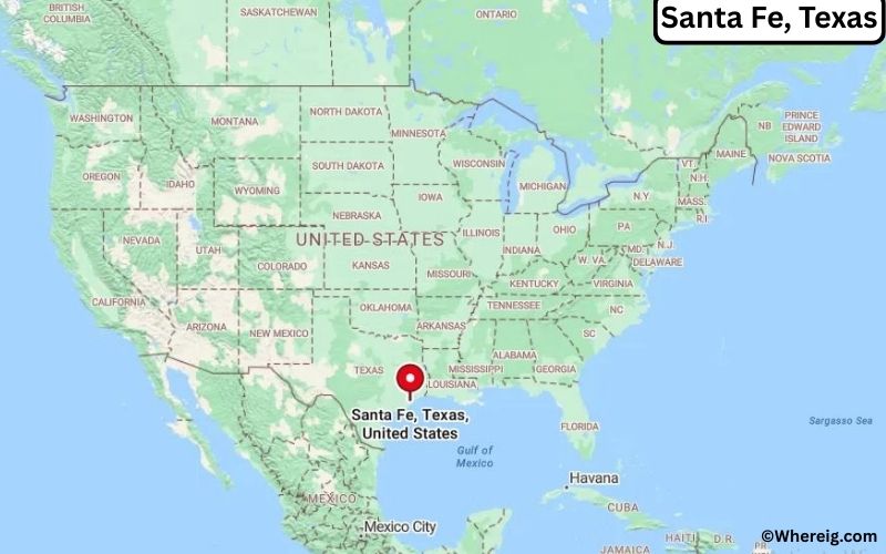
About Map: The map shows the location of Santa Fe in the state of Texas, United States. Santa Fe is a city in Galveston County, Texas.
Santa Fe Map, Texas, USA
About Santa Fe Map: This interactive Google Map shows the exact location of Santa Fe in Texas, United States. You can zoom in or out, switch to satellite view, and explore nearby cities, roads, and local landmarks around Santa Fe.
About Santa Fe, Galveston County, Texas
Santa Fe is a city located in Galveston County in the U.S. state of Texas, United States. The city was established in the late nineteenth century following the expansion of the Gulf, Colorado and Santa Fe Railway, from which the community takes its name. Santa Fe developed as an agricultural settlement and later grew as a residential community within the greater Houston–Galveston metropolitan region.
Population
According to the United States Census Bureau, the population of Santa Fe is 13,442 as recorded in the 2020 Census, and the population density is approximately 760 people per square mile.
Geography
According to the United States Census Bureau, Santa Fe covers a total area of approximately 17.0 square miles (about 44.0 square kilometers), including about 17.0 square miles (44.0 square kilometers) of land and a very small portion of water area.
Location and Surroundings
Santa Fe is located in southeastern Texas and lies within Galveston County between the cities of Houston and Galveston. The city forms part of the greater Houston metropolitan area and is surrounded by coastal plains and suburban communities.
Top Attractions
Santa Fe offers parks, community recreation areas, and local events that reflect the culture of the Texas Gulf Coast. Residents enjoy outdoor spaces, sports facilities, and easy access to nearby coastal attractions and entertainment venues.
Transportation
Santa Fe is served by State Highway 6 and several regional roadways that connect the city with Houston, Galveston, and surrounding communities. The nearest major airport serving the region is William P. Hobby Airport.
Explore more cities and counties across Texas or view the complete USA States Map for additional geographic information.
Sources:
Population and area data sourced from the United States Census Bureau (2020 Census). General information referenced from local and regional government resources.
Most Viewed US Maps
| USA Sttae Map | USA Region Map | USA Road Map |
| USA County Map | Where is USA in World Map? | US ZIP Code Map |
| USA Time Zones Map | US State and Capitals Map | USA Physical Map |
Find 4,400+ U.S. Cities by State - Explore Their Locations and Get Detailed Information
Santa Fe, Texas Quick Facts
| Attribute | Details |
|---|---|
| City | Santa Fe |
| County | Galveston County |
| State | Texas |
| State Capital | Austin |
| US Region | South |
| Latitude | 29.3788° N |
| Longitude | 95.1058° W |
| Elevation | 33 ft (10 m) |
| Land Area | 16.20 sq mi |
| Water Area | 0.02 sq mi |
| Total Area | 16.22 sq mi |
| Population (2020 Census) | 12,735 |
| Population Density | 786 per sq mi |
| ZIP Code | 77510 |
| Area Code | 409 |
| Time Zone Standard | Central Standard Time (CST), UTC−6 |
| Time Zone Daylight | Central Daylight Time (CDT), UTC−5 |
| Currency | United States Dollar (USD) |
| FIPS Code | 48-65684 |
| Congressional District | Texas' 14th Congressional District |
Transportation and Connectivity in Santa Fe, Texas
| Transportation Type | Details |
|---|---|
| Airport Name | William P. Hobby Airport / George Bush Intercontinental Airport |
| IATA Code | HOU / IAH |
| Port | Port of Galveston / Port Houston |
| Major Highways | State Highway 6, Farm to Market Road 1764, Interstate 45 (Nearby) |
| Train Service | No passenger rail service within city; regional access through nearby Houston area |
| Local Bus/Transit Service | Local road transportation; regional transit connections through Galveston County |
- State Highway 6: Main route connecting Santa Fe with Alvin, Bay Area Houston, and Galveston County communities.
- Farm to Market Road 1764: Provides east-west regional access toward Texas City and surrounding areas.
- Interstate 45: Nearby freeway connecting Galveston, Houston, and other Southeast Texas destinations.
- William P. Hobby Airport: Provides commercial air service for the region.
Top Places to Visit in Santa Fe, Texas
| Landmark Name | Type |
|---|---|
| Santa Fe Trail | Historic Route and Community Landmark |
| Santa Fe City Park | Community Recreation Area |
| Galveston Island State Park | Beach and Nature Area |
| Moody Gardens | Educational and Family Attraction |
| Galveston Island Historic Pleasure Pier | Waterfront Entertainment Area |
| Big Reef Nature Park | Coastal Recreation Area |
| Dickinson Bayou | Water Recreation Area |
| Bayou Wildlife Zoo | Wildlife Attraction |
| Texas City Dike | Fishing and Recreation Area |
| Galveston Island Historic District | Historic District |
Driving Distances from Santa Fe, Texas to Nearby Cities
| City | State | Distance (mi) | Approx. Drive Time |
|---|---|---|---|
| Texas City | Texas | 10 mi | 15 minutes |
| Galveston | Texas | 25 mi | 35 minutes |
| League City | Texas | 15 mi | 25 minutes |
| Friendswood | Texas | 18 mi | 30 minutes |
| Houston | Texas | 35 mi | 45 minutes |
| Pearland | Texas | 30 mi | 40 minutes |
| Baytown | Texas | 60 mi | 1 hour |
| Beaumont | Texas | 100 mi | 1 hour 40 minutes |
| Victoria | Texas | 130 mi | 2 hours |
| Austin | Texas | 190 mi | 3 hours |
Colleges and Universities Near Santa Fe, Texas
| Institution Name | Type | Level | Notable For |
|---|---|---|---|
| Mainland Campus, College of the Mainland | Public | Community College | Career education, technical programs, healthcare, and workforce training |
| Galveston College | Public | Community College | Marine science, nursing, workforce programs, and academics |
| University of Houston–Clear Lake | Public | University | Business, education, science, and professional programs |
| University of Houston | Public | University | Research, engineering, business, and academic programs |
| Santa Fe Independent School District | Public | K–12 District | Primary and secondary education |
Waterbodies Near Santa Fe, Texas
Dickinson Bayou, Highland Bayou, Galveston Bay, Clear Creek, and nearby coastal waterways throughout Galveston County.
Golf Courses Near Santa Fe
Bayou Golf Course, Moody Gardens Golf Course, Galveston Country Club, Bay Oaks Country Club, and Timber Creek Golf Club.
Santa Fe, Texas — Key Historical Facts
- The Santa Fe area was developed as part of the agricultural communities of Galveston County.
- The city was named after the Santa Fe Railroad, which helped connect the area with regional markets.
- Santa Fe was incorporated as a city in 1978 and grew from a rural farming community into a suburban area.
- The community has maintained a connection to agriculture, small businesses, and the coastal economy.
- Today, Santa Fe is known for its small-town character, proximity to Galveston Island, and location within the Houston metropolitan region.
Stadiums and Sports Facilities Near Santa Fe
| Facility Name | Type | Location |
|---|---|---|
| Santa Fe High School Stadium | High School Sports Stadium | Santa Fe, Texas |
| Santa Fe ISD Athletic Facilities | School Sports Facility | Santa Fe, Texas |
| Galveston College Athletic Facilities | College Sports Facility | Galveston, Texas |
| Hofheinz Pavilion / Fertitta Center | College Sports Arena | Houston, Texas |
| NRG Stadium | Professional Sports Stadium | Houston, Texas |
References
- City of Santa Fe, Texas Official Website
- Galveston County Government
- U.S. Census Bureau
- Texas Tourism
- College of the Mainland
Texas Maps and Info
- Where is Nederland
- Where is South Houston
- Where is Bellaire
- Where is Mineral Wells
- Where is Groves
- Where is White Settlement
- Where is Gainesville
- Where is Terrell
- Where is Donna
- Where is Gatesville
- Where is Uvalde
- Where is Brenham
- Where is Mercedes
- Where is Mount Pleasant
- Where is Sulphur Springs
- Where is Hereford
- Where is Taylor
- Where is Humble
- Where is Portland
- Where is Highland Village
- Where is Seagoville
- Where is West University Place
- Where is Dumas
- Where is Jacksonville
- Where is La Marque
- Where is Rio Grande City
- Where is Henderson
- Where is Hewitt
- Where is Levelland
- Where is Canyon
- Where is Borger
- Where is Live Oak
- Where is Addison
- Where is Port Neches
- Where is Kilgore
- Where is Beeville
- Where is Crowley
- Where is Athens
- Where is Lockhart
- Where is Forest Hill
- Where is Alton
- Where is Port Lavaca
- Where is Santa Fe
- Where is Freeport
- Where is Seabrook
- Where is Lumberton
- Where is Richmond
- Where is El Campo
- Where is Robstown
- Where is Raymondville
- Where is Glenn Heights
- Where is Clute
- Where is Snyder
- Where is Hidalgo
- Where is Andrews
- Where is Vernon
- Where is Azle
- Where is Sweetwater
- Where is Galena Park
- Where is Burkburnett
- Where is Red Oak
- Where is Tomball
- Where is Vidor
- Where is Jacinto City
- Where is Fredericksburg
- Where is Robinson
- Where is Boerne
- Where is Webster
- Where is Leon Valley
- Where is Bonham
- Where is Bellmead
- Where is Roma
- Where is Brownfield
- Where is Prosper
- Where is Lamesa
- Where is Ingleside
- Where is Royse City
- Where is Pearsall
- Where is Pleasanton
- Where is Graham
- Where is Wharton
- Where is Hondo
- Where is Perryton
- Where is Pecos
- Where is Rockport
- Where is Highland Park
- Where is Hillsboro
- Where is Woodway
- Where is Liberty
- Where is Fort Stockton
- Where is Anna
- Where is Aransas Pass
- Where is Commerce
- Where is Trophy Club
- Where is Kirby