
Where is Prosper, Texas Located in the United States? - Prosper is a city located in the Collin County of Texas, United States. Prosper lies between 33.2368 Degrees North latitudes and -96.8011 Degrees West longitudes.
Location Map of Prosper in Collin County, Texas
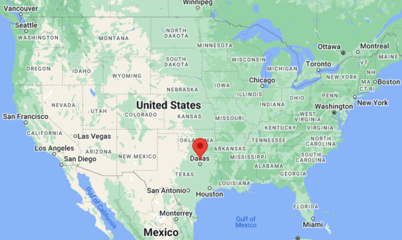
About Map: The map shows the location of Prosper in the state of Texas, United States. Prosper is a city in Collin County, Texas.
Prosper Map, Texas, USA
About Prosper Map: This interactive Google Map shows the exact location of Prosper in Texas, United States. You can zoom in or out, switch to satellite view, and explore nearby cities, roads, and local landmarks around Prosper.
About Prosper, Collin County, Texas
Prosper is a town located in Collin County in the U.S. state of Texas, United States. The town was established in 1914 and was named to reflect the hopes of early settlers for prosperity and growth in the community. Prosper developed as a small agricultural settlement and has rapidly grown into a residential suburb within the Dallas–Fort Worth metropolitan region.
Population
According to the United States Census Bureau, the population of Prosper is 30,174 as recorded in the 2020 Census, and the population density is approximately 1,200 people per square mile.
Geography
According to the United States Census Bureau, Prosper covers a total area of approximately 24.5 square miles (about 63.5 square kilometers), including about 24.5 square miles (63.5 square kilometers) of land and a very small amount of water area.
Location and Surroundings
Prosper is located in north-central Texas and lies within Collin County north of the city of Dallas. The town forms part of the Dallas–Fort Worth metropolitan region and is surrounded by rapidly expanding suburban communities.
Top Attractions
Prosper offers parks, community recreation facilities, and local events that reflect the town’s family-oriented atmosphere. Residents enjoy outdoor activities, sports facilities, and community gatherings throughout the year.
Transportation
Prosper is served by U.S. Highway 380 and the Dallas North Tollway, providing convenient access to Dallas and surrounding cities across North Texas. The nearest major airport serving the region is Dallas/Fort Worth International Airport.
Explore more cities and counties across Texas or view the complete USA States Map for additional geographic information.
Sources:
Population and area data sourced from the United States Census Bureau (2020 Census). General information referenced from local and regional government resources.
Most Viewed US Maps
| USA Sttae Map | USA Region Map | USA Road Map |
| USA County Map | Where is USA in World Map? | US ZIP Code Map |
| USA Time Zones Map | US State and Capitals Map | USA Physical Map |
Find 4,400+ U.S. Cities by State - Explore Their Locations and Get Detailed Information
Prosper, Texas Quick Facts
| Attribute | Details |
|---|---|
| City | Prosper |
| County | Collin County and Denton County |
| State | Texas |
| State Capital | Austin |
| US Region | Southern United States (West South Central Region) |
| Latitude | 33.2362° N |
| Longitude | 96.8011° W |
| Elevation | 768 ft (234 m) |
| Land Area | 27.00 sq mi |
| Water Area | 0.04 sq mi |
| Total Area | 27.04 sq mi |
| Population (2020 Census) | 30,174 |
| Population Density | Approximately 1,118 people per sq mi |
| ZIP Code | 75078 |
| Area Code | 972, 469, 214 |
| Time Zone Standard | Central Standard Time (CST, UTC−6) |
| Time Zone Daylight | Central Daylight Time (CDT, UTC−5) |
| Currency | United States Dollar (USD) |
| FIPS Code | 48-59588 |
| Congressional District | Texas' 26th Congressional District |
Transportation and Connectivity in Prosper
| Category | Details |
|---|---|
| Airport Name | Dallas/Fort Worth International Airport |
| IATA Code | DFW |
| Port | Regional inland transportation access |
| Major Highways | U.S. Route 380, Dallas North Tollway, Preston Road (SH 289), Frontier Parkway |
| Train/Amtrak Service | Nearest Amtrak service in Dallas |
| Local Bus/Transit Service | Regional transit connections through DART and nearby services |
- U.S. Route 380 – Major east–west highway connecting Prosper with McKinney, Denton, and other North Texas communities.
- Dallas North Tollway – Provides direct access toward Frisco, Plano, and the Dallas business area.
- Preston Road (State Highway 289) – Historic north–south route serving Prosper and surrounding communities.
- Frontier Parkway – Important local roadway supporting residential and commercial growth.
Top Places to Visit in Prosper, Texas
| Landmark Name | Type |
|---|---|
| Prosper Town Lake Park | Community Park |
| Frontier Park | Recreation Area |
| Whispering Farms Equestrian Center | Equestrian Facility |
| Prosper Historical Park | Historic Area |
| Preston Lakes | Residential Lake Area |
| Ray Roberts Lake State Park | State Park |
| Lake Lewisville | Recreation Lake |
| Hagerman National Wildlife Refuge | Wildlife Area |
| Downtown Prosper | Historic District |
| The Star in Frisco | Sports and Entertainment Venue |
Driving Distances from Prosper, Texas to Nearby Cities
| City | State | Distance (mi) | Approx. Drive Time |
|---|---|---|---|
| Frisco | Texas | 12 | 20 minutes |
| McKinney | Texas | 18 | 25 minutes |
| Denton | Texas | 30 | 35 minutes |
| Plano | Texas | 30 | 40 minutes |
| Dallas | Texas | 35 | 45 minutes |
| Fort Worth | Texas | 55 | 1 hour |
| Arlington | Texas | 60 | 1 hour 10 minutes |
| Waco | Texas | 130 | 2 hours |
| Oklahoma City | Oklahoma | 170 | 2 hours 45 minutes |
| Austin | Texas | 220 | 3 hours 30 minutes |
Colleges and Universities Near Prosper, Texas
| Institution Name | Type | Level | Notable For |
|---|---|---|---|
| Collin College – Frisco Campus | Public | Community College | Transfer education, workforce training, and career programs |
| University of North Texas | Public | University | Research, business, music, education, and sciences |
| Texas Woman's University | Public | University | Health sciences, education, business, and liberal arts |
| University of Texas at Dallas | Public | University | Technology, engineering, business, and research |
| Southern Methodist University | Private | University | Business, law, engineering, and arts |
| Prosper Independent School District | Public | K–12 District | Primary and secondary education |
Waterbodies in Prosper, Texas
Prosper is located near several North Texas waterways including Doe Branch, Mustang Creek, Lake Ray Roberts, Lake Lewisville, and nearby creeks and drainage systems of Collin and Denton Counties.
Golf Courses Near Prosper
Gentle Creek Country Club, Prosper Golf & Country Club, The Trails of Frisco Golf Club, Plantation Golf Club, and Stonebriar Country Club.
Prosper, Texas — Key Historical Facts
- Prosper was founded in the late nineteenth century as an agricultural community along the St. Louis, San Francisco and Texas Railway line.
- Early settlers developed farms focused on cotton, wheat, and other crops that supported the local economy. :contentReference[oaicite:0]{index=0}
- The town was incorporated in 1914 and grew slowly as a rural farming community before experiencing rapid suburban growth in the late twentieth century. :contentReference[oaicite:1]{index=1}
- Prosper became one of the fastest-growing communities in North Texas as development expanded north of the Dallas–Fort Worth metropolitan area. :contentReference[oaicite:2]{index=2}
- Today, Prosper is known for planned neighborhoods, strong schools, parks, community events, and its location near major North Texas employment centers. :contentReference[oaicite:3]{index=3}
References
Texas Maps and Info
- Where is Nederland
- Where is South Houston
- Where is Bellaire
- Where is Mineral Wells
- Where is Groves
- Where is White Settlement
- Where is Gainesville
- Where is Terrell
- Where is Donna
- Where is Gatesville
- Where is Uvalde
- Where is Brenham
- Where is Mercedes
- Where is Mount Pleasant
- Where is Sulphur Springs
- Where is Hereford
- Where is Taylor
- Where is Humble
- Where is Portland
- Where is Highland Village
- Where is Seagoville
- Where is West University Place
- Where is Dumas
- Where is Jacksonville
- Where is La Marque
- Where is Rio Grande City
- Where is Henderson
- Where is Hewitt
- Where is Levelland
- Where is Canyon
- Where is Borger
- Where is Live Oak
- Where is Addison
- Where is Port Neches
- Where is Kilgore
- Where is Beeville
- Where is Crowley
- Where is Athens
- Where is Lockhart
- Where is Forest Hill
- Where is Alton
- Where is Port Lavaca
- Where is Santa Fe
- Where is Freeport
- Where is Seabrook
- Where is Lumberton
- Where is Richmond
- Where is El Campo
- Where is Robstown
- Where is Raymondville
- Where is Glenn Heights
- Where is Clute
- Where is Snyder
- Where is Hidalgo
- Where is Andrews
- Where is Vernon
- Where is Azle
- Where is Sweetwater
- Where is Galena Park
- Where is Burkburnett
- Where is Red Oak
- Where is Tomball
- Where is Vidor
- Where is Jacinto City
- Where is Fredericksburg
- Where is Robinson
- Where is Boerne
- Where is Webster
- Where is Leon Valley
- Where is Bonham
- Where is Bellmead
- Where is Roma
- Where is Brownfield
- Where is Prosper
- Where is Lamesa
- Where is Ingleside
- Where is Royse City
- Where is Pearsall
- Where is Pleasanton
- Where is Graham
- Where is Wharton
- Where is Hondo
- Where is Perryton
- Where is Pecos
- Where is Rockport
- Where is Highland Park
- Where is Hillsboro
- Where is Woodway
- Where is Liberty
- Where is Fort Stockton
- Where is Anna
- Where is Aransas Pass
- Where is Commerce
- Where is Trophy Club
- Where is Kirby