Map of Navajo County - Navajo County is a county located in the U.S. state of Arizona. Navajo County Map showing cities, highways, important places and water bodies. Get Where is Navajo County located in the map, major cities in Navajo county, population, areas, and places of interest.
Navajo County Map, Arizona
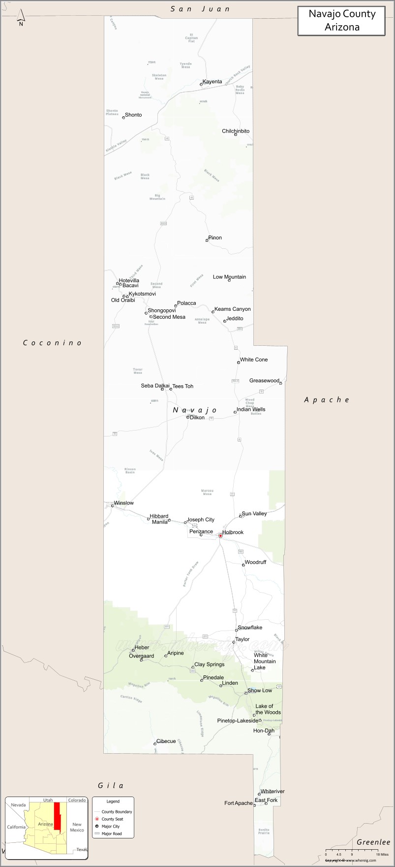
About Navajo County Map, Arizona: The map showing the county boundary, county seat, major cities, highways, water bodies and neighbouring counties.
Most Viewed Arizona Maps
Map of Navajo County, Arizona
Navajo County is a county located in the U.S. state of Arizona. It's county seat is Holbrook. As per 2020 census, the population of Navajo County is 108147 people and population density is square miles. According to the United States Census Bureau, the county has a total area of 9,959 sq mi (25,794 km2). Navajo County was established on 1895.
Navajo County Facts
| County Info | Facts |
|---|---|
| County | Navajo County |
| County Seat | Holbrook |
| State | Arizona |
| Country | United States |
| FIPS code | 17 |
| Established | 1895 |
| Area | 9,959 sq mi (25,794 km2) |
| Population | 108147 |
| Density | |
| Formed / Origin | Apache County |
Ctities and Towns in Navajo
| City Name | Type | Population (2020) | Pop. Density | Area | Incorporated |
|---|---|---|---|---|---|
| Holbrook | City | 4,858 | 280.2/sq mi (108.2/km2) | 17.34 sq mi (44.9 km2) | 1917 |
| Pinetop-Lakeside | Town | 4,030 | 361.4/sq mi (139.6/km2) | 11.15 sq mi (28.9 km2) | 1984 |
| Show Low | City | 11,732 | 179.1/sq mi (69.2/km2) | 65.5 sq mi (169.6 km2) | 1953 |
| Snowflake | Town | 6,104 | 180.9/sq mi (69.9/km2) | 33.74 sq mi (87.4 km2) | 1948 |
| Taylor | Town | 3,995 | 122.3/sq mi (47.2/km2) | 32.66 sq mi (84.6 km2) | 1966 |
| Winslow | City | 9,005 | 693.2/sq mi (267.7/km2) | 12.99 sq mi (33.6 km2) | 1900 |
Places to Visit in Navajo
Top places to visit in london includes Monument Valley, Wigwam Motel, Homolovi State Park, Fool Hollow Lake Recreation Area, Wildcat Trail,Painted Desert, Petrified Forest National Park, Meteor Crater Natural Landmark.
Highways in Navajo
Interstate 40, U.S. Route 60, U.S. Route 160, U.S. Route 163, U.S. Route 180, State Route 73, State Route 77, State Route 87, State Route 98, State Route 99, State Route 260, State Route 264, State Route 277, State Route 377.
Nearest Airports
Nearest airport of Navajo is Show Low Regional Airport (SOW / KSOW).
- Alabama Counties
- Alaska boroughs
- Arizona Counties
- Arkansas Counties
- California County Map
- Colorado Counties
- Connecticut Counties
- Delaware Counties
- Florida County Map
- Georgia County Map
- Hawaii Counties
- Idaho Counties
- Illinois Counties
- Indiana Counties
- Iowa Counties
- Kansas Counties
- Kentucky Counties
- Louisiana Counties
- Maine Counties
- Maryland Counties
- Massachusetts Counties
- Michigan County Map
- Minnesota Counties
- Mississippi Counties
- Missouri Counties
- Montana Counties
- Nebraska Counties
- Nevada Counties
- New York Counties
- New Hampshire Counties
- New Jersey Counties
- New Mexico Counties
- North Carolina Counties
- North Dakota Counties
- Ohio County Map
- Oklahoma Counties
- Oregon Counties
- Pennsylvania Counties
- Rhode Island Counties
- South Carolina Counties
- South Dakota Counties
- Map of Tennessee
- Texas County Map
- Utah Counties
- Vermont Counties
- Virginia Counties
- Washington Counties
- West Virginia Counties
- Wisconsin Counties
- Wyoming Counties