Map of Yavapai County - Yavapai County is a county located in the U.S. state of Arizona. Yavapai County Map showing cities, highways, important places and water bodies. Get Where is Yavapai County located in the map, major cities in Yavapai county, population, areas, and places of interest.
Yavapai County Map, Arizona
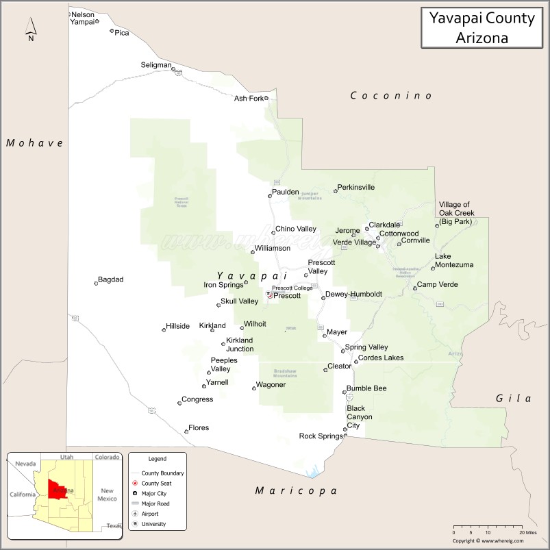
About Yavapai County Map, Arizona: The map showing the county boundary, county seat, major cities, highways, water bodies and neighbouring counties.
Most Viewed Arizona Maps
Map of Yavapai County, Arizona
Yavapai County is a county located in the U.S. state of Arizona. It's county seat is Prescott. As per 2020 census, the population of Yavapai County is 242253 people and population density is square miles. According to the United States Census Bureau, the county has a total area of 8,128 sq mi (21,051 km2). Yavapai County was established on 1864.
Yavapai County Facts
| County Info | Facts |
|---|---|
| County | Yavapai County |
| County Seat | Prescott |
| State | Arizona |
| Country | United States |
| FIPS code | 25 |
| Established | 1864 |
| Area | 8,128 sq mi (21,051 km2) |
| Population | 242253 |
| Density | |
| Formed / Origin | ? |
Ctities and Towns in Yavapai
| City Name | Type | Population (2020) | Pop. Density | Area | Incorporated |
|---|---|---|---|---|---|
| Camp Verde | Town | 12,147 | 286.8/sq mi (110.7/km2) | 42.35 sq mi (109.7 km2) | 1986 |
| Chino Valley | Town | 13,020 | 208.6/sq mi (80.5/km2) | 62.42 sq mi (161.7 km2) | 1970 |
| Clarkdale | Town | 4,424 | 434.6/sq mi (167.8/km2) | 10.18 sq mi (26.4 km2) | 1957 |
| Cottonwood | City | 12,029 | 724.6/sq mi (279.8/km2) | 16.6 sq mi (43 km2) | 1960 |
| Dewey-Humboldt | Town | 4,326 | 230.2/sq mi (88.9/km2) | 18.79 sq mi (48.7 km2) | 2004 |
| Jerome | Town | 464 | 587.3/sq mi (226.8/km2) | 0.79 sq mi (2 km2) | 1889 |
| Prescott | City | 45,827 | 1,019.1/sq mi (393.5/km2) | 44.97 sq mi (116.5 km2) | 1883 |
| Prescott Valley | Town | 46,785 | 1,156.0/sq mi (446.4/km2) | 40.47 sq mi (104.8 km2) | 1978 |
| Sedona | City | 9,684 | 530.3/sq mi (204.8/km2) | 18.26 sq mi (47.3 km2) | 1988 |
Places to Visit in Yavapai
Top places to visit in london includes Montezuma Castle National Monument,Verde Canyon Railroad, Tuzigoot National Monument, Sedona Airport Scenic Lookout, Devil's Bridge Trailhead, Red Rock State Park, Amitabha Stupa and Peace Park, Watson Lake Park, Heritage Park Zoological,Airport Mesa, Montezuma Well (Montezuma Castle, Red Rock Ranger District Visitor, Boynton Canyon Trail, Cathedral Rock, Bell Rock, Jerome State Historic Park, Seven Sacred Pools, Fossil Creek, Goldwater Lake, Predator Zip Lines, Watson Lake, Seven Canyons Golf Club, Bear Mountain Trail, Fossil Creek Waterfall, Schuerman Mountain Trailhead.
Highways in Yavapai
Interstate 17, Interstate 40, U.S. Route 93, State Route 69, State Route 71, State Route 89, State Route 169, State Route 179, State Route 260, State Route 279.
Nearest Airports
Nearest airport of Yavapai is Prescott Municipal Airport, Ernest A. Love Field (PRC / KPRC).
- Alabama Counties
- Alaska boroughs
- Arizona Counties
- Arkansas Counties
- California County Map
- Colorado Counties
- Connecticut Counties
- Delaware Counties
- Florida County Map
- Georgia County Map
- Hawaii Counties
- Idaho Counties
- Illinois Counties
- Indiana Counties
- Iowa Counties
- Kansas Counties
- Kentucky Counties
- Louisiana Counties
- Maine Counties
- Maryland Counties
- Massachusetts Counties
- Michigan County Map
- Minnesota Counties
- Mississippi Counties
- Missouri Counties
- Montana Counties
- Nebraska Counties
- Nevada Counties
- New York Counties
- New Hampshire Counties
- New Jersey Counties
- New Mexico Counties
- North Carolina Counties
- North Dakota Counties
- Ohio County Map
- Oklahoma Counties
- Oregon Counties
- Pennsylvania Counties
- Rhode Island Counties
- South Carolina Counties
- South Dakota Counties
- Map of Tennessee
- Texas County Map
- Utah Counties
- Vermont Counties
- Virginia Counties
- Washington Counties
- West Virginia Counties
- Wisconsin Counties
- Wyoming Counties