Map of Maricopa County - Maricopa County is a county located in the U.S. state of Arizona. Maricopa County Map showing cities, highways, important places and water bodies. Get Where is Maricopa County located in the map, major cities in Maricopa county, population, areas, and places of interest.
Maricopa County Map, Arizona
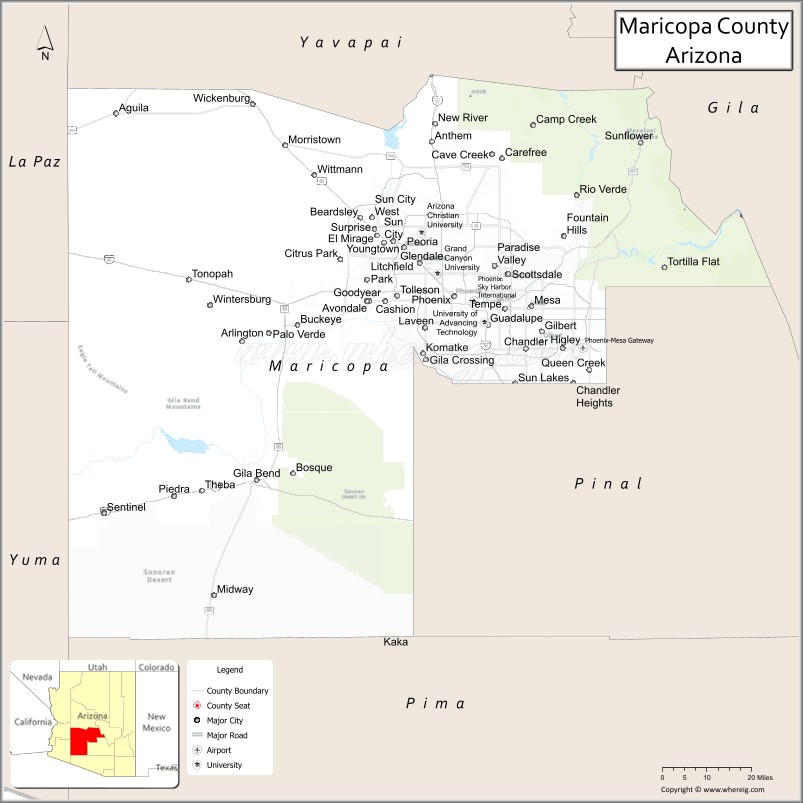
About Maricopa County Map, Arizona: The map showing the county boundary, county seat, major cities, highways, water bodies and neighbouring counties.
Most Viewed Arizona Maps
Map of Maricopa County, Arizona
Maricopa County is a county located in the U.S. state of Arizona. It's county seat is Phoenix. As per 2020 census, the population of Maricopa County is 4496588 people and population density is square miles. According to the United States Census Bureau, the county has a total area of 9,224 sq mi (23,890 km2). Maricopa County was established on 1871.
Maricopa County Facts
| County Info | Facts |
|---|---|
| County | Maricopa County |
| County Seat | Phoenix |
| State | Arizona |
| Country | United States |
| FIPS code | 13 |
| Established | 1871 |
| Area | 9,224 sq mi (23,890 km2) |
| Population | 4496588 |
| Density | |
| Formed / Origin | Pima and Yavapai Counties |
Ctities and Towns in Maricopa
| City Name | Type | Population (2020) | Pop. Density | Area | Incorporated |
|---|---|---|---|---|---|
| Avondale | City | 89,334 | 1,889.5/sq mi (729.5/km2) | 47.28 sq mi (122.5 km2) | 1946 |
| Buckeye | City | 91,502 | 232.8/sq mi (89.9/km2) | 392.98 sq mi (1017.8 km2) | 1929 |
| Carefree | Town | 3,690 | 418.8/sq mi (161.7/km2) | 8.81 sq mi (22.8 km2) | 1984 |
| Cave Creek | Town | 4,892 | 129.7/sq mi (50.1/km2) | 37.71 sq mi (97.7 km2) | 1986 |
| Chandler | City | 275,987 | 4,226.4/sq mi (1,631.8/km2) | 65.3 sq mi (169.1 km2) | 1920 |
| El Mirage | City | 35,805 | 3,616.7/sq mi (1,396.4/km2) | 9.9 sq mi (25.6 km2) | 1951 |
| Fountain Hills | Town | 23,820 | 1,174.6/sq mi (453.5/km2) | 20.28 sq mi (52.5 km2) | 1989 |
| Gila Bend | Town | 1,892 | 29.4/sq mi (11.3/km2) | 64.37 sq mi (166.7 km2) | 1962 |
| Gilbert | Town | 267,918 | 3,907.2/sq mi (1,508.6/km2) | 68.57 sq mi (177.6 km2) | 1920 |
| Glendale | City | 248,325 | 4,031.3/sq mi (1,556.5/km2) | 61.6 sq mi (159.5 km2) | 1910 |
| Goodyear | City | 95,294 | 498.1/sq mi (192.3/km2) | 191.3 sq mi (495.5 km2) | 1946 |
| Guadalupe | Town | 5,322 | 6,652.5/sq mi (2,568.5/km2) | 0.8 sq mi (2.1 km2) | 1975 |
| Litchfield Park | City | 6,847 | 2,087.5/sq mi (806.0/km2) | 3.28 sq mi (8.5 km2) | 1987 |
| Mesa | City | 504,258 | 3,635.6/sq mi (1,403.7/km2) | 138.7 sq mi (359.2 km2) | 1883 |
| Paradise Valley | Town | 12,658 | 823.0/sq mi (317.8/km2) | 15.38 sq mi (39.8 km2) | 1961 |
| Peoria | City | 190,985 | 1,084.6/sq mi (418.8/km2) | 176.08 sq mi (456 km2) | 1954 |
| Phoenix | City | 1,608,139 | 3,104.5/sq mi (1,198.7/km2) | 518 sq mi (1341.6 km2) | 1881 |
| Queen Creek | Town | 59,519 | 1,476.2/sq mi (570.0/km2) | 40.32 sq mi (104.4 km2) | 1989 |
| Scottsdale | City | 241,361 | 1,311.7/sq mi (506.5/km2) | 184 sq mi (476.6 km2) | 1951 |
| Surprise | City | 143,148 | 1,297.8/sq mi (501.1/km2) | 110.3 sq mi (285.7 km2) | 1960 |
| Tempe | City | 180,587 | 4,521.5/sq mi (1,745.7/km2) | 39.94 sq mi (103.4 km2) | 1894 |
| Tolleson | City | 7,216 | 1,259.3/sq mi (486.2/km2) | 5.73 sq mi (14.8 km2) | 1929 |
| Wickenburg | Town | 7,474 | 289.0/sq mi (111.6/km2) | 25.86 sq mi (67 km2) | 1909 |
| Youngtown | Town | 7,056 | 4,735.6/sq mi (1,828.4/km2) | 1.49 sq mi (3.9 km2) | 1960 |
Places to Visit in Maricopa
Top places to visit in london includes Desert Botanical Garden, Phoenix Zoo, Hole in the Rock ,Skydive Phoenix Inc, Papago Park, OdySea Aquarium, Westgate Entertainment, South Mountain Park and Preserve, McCormick-Stillman Railroad Park, Riparian Preserve at Water Ranch, Encanto Parkm, The Japanese Friendship Garden, Camelback Mountain, Phoenix Art Museum, Mesa Arts Center, Arizona Soaring Inc, Phoenix Mountains Preserve, Usery Mountain Regional Park, SEA LIFE Arizona Aquarium, Echo Canyon Trailhead, Echo Canyon Trailhead, Enchanted Island Amusement Park, Troon North Golf Club, Cosanti Originals, Theodore Roosevelt Dam, Downtown Tempe, White Tank Mountain Regional Park.
Highways in Maricopa
Interstate 8, Interstate 10, Interstate 17, U.S. Route 60, Historic U.S. Route 80, U.S. Route 93, Loop 101, Loop 202, Loop 303, State Route 51, State Route 71, State Route 74, State Route 85, State Route 87, State Route 143, State Route 347.
Nearest Airports
Nearest airport of Maricopa is Sky Harbor International Airport (PHX).
- Alabama Counties
- Alaska boroughs
- Arizona Counties
- Arkansas Counties
- California County Map
- Colorado Counties
- Connecticut Counties
- Delaware Counties
- Florida County Map
- Georgia County Map
- Hawaii Counties
- Idaho Counties
- Illinois Counties
- Indiana Counties
- Iowa Counties
- Kansas Counties
- Kentucky Counties
- Louisiana Counties
- Maine Counties
- Maryland Counties
- Massachusetts Counties
- Michigan County Map
- Minnesota Counties
- Mississippi Counties
- Missouri Counties
- Montana Counties
- Nebraska Counties
- Nevada Counties
- New York Counties
- New Hampshire Counties
- New Jersey Counties
- New Mexico Counties
- North Carolina Counties
- North Dakota Counties
- Ohio County Map
- Oklahoma Counties
- Oregon Counties
- Pennsylvania Counties
- Rhode Island Counties
- South Carolina Counties
- South Dakota Counties
- Map of Tennessee
- Texas County Map
- Utah Counties
- Vermont Counties
- Virginia Counties
- Washington Counties
- West Virginia Counties
- Wisconsin Counties
- Wyoming Counties