Map of Cochise County - Cochise County is a county located in the U.S. state of Arizona. Cochise County Map showing cities, highways, important places and water bodies. Get Where is Cochise County located in the map, major cities in Cochise county, population, areas, and places of interest.
Cochise County Map, Arizona
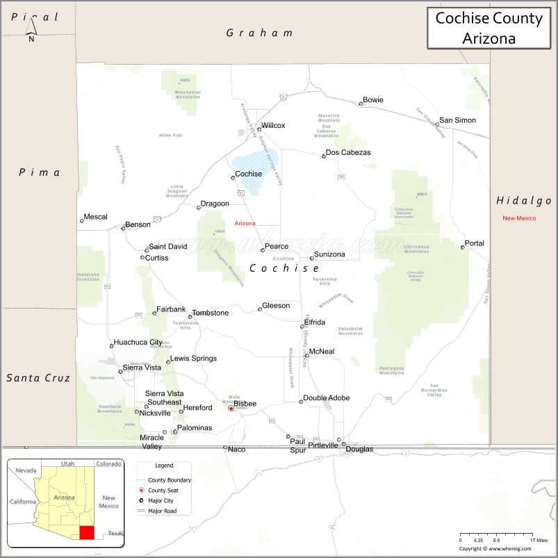
About Cochise County Map, Arizona: The map showing the county boundary, county seat, major cities, highways, water bodies and neighbouring counties.
Most Viewed Arizona Maps
Map of Cochise County, Arizona
Cochise County is a county located in the U.S. state of Arizona. It's county seat is Bisbee. As per 2020 census, the population of Cochise County is 126050 people and population density is square miles. According to the United States Census Bureau, the county has a total area of 6,219 sq mi (16,107 km2). Cochise County was established on 1881.
Cochise County Facts
| County Info | Facts |
|---|---|
| County | Cochise County |
| County Seat | Bisbee |
| State | Arizona |
| Country | United States |
| FIPS code | 3 |
| Established | 1881 |
| Area | 6,219 sq mi (16,107 km2) |
| Population | 126050 |
| Density | |
| Formed / Origin | Pima County |
Ctities and Towns in Cochise
| City Name | Type | Population (2020) | Pop. Density | Area | Incorporated |
|---|---|---|---|---|---|
| Benson | City | 5,355 | 128.6/sq mi (49.7/km2) | 41.64 sq mi (107.8 km2) | 1924 |
| Bisbee | City | 4,923 | 950.4/sq mi (366.9/km2) | 5.18 sq mi (13.4 km2) | 1902 |
| Douglas | City | 16,534 | 1,656.7/sq mi (639.7/km2) | 9.98 sq mi (25.8 km2) | 1905 |
| Huachuca City | Town | 1,626 | 574.6/sq mi (221.8/km2) | 2.83 sq mi (7.3 km2) | 1958 |
| Sierra Vista | City | 45,308 | 297.6/sq mi (114.9/km2) | 152.25 sq mi (394.3 km2) | 1956 |
| Tombstone | City | 1,308 | 141.4/sq mi (54.6/km2) | 9.25 sq mi (24 km2) | 1881 |
| Willcox | City | 3,213 | 522.4/sq mi (201.7/km2) | 6.15 sq mi (15.9 km2) | 1915 |
Places to Visit in Cochise
Top places to visit in london includes Chiricahua National Monument, Kartchner Caverns State Park, Queen Mine Tour, Coronado National Memorial, Veterans Memorial Park, Old Tombstone Western Theme Park, Our Lady Of The Sierras (Cerro De La, Good Enough Mine Tour.
Highways in Cochise
Interstate 10, US 80 , Historic U.S. Route 80, U.S. Route 191, State Route 80, State Route 82, State Route 83, State Route 90, State Route 92, State Route 186.
Nearest Airports
Nearest airport of Cochise is Tucson International Airport (TUS / KTUS).
- Alabama Counties
- Alaska boroughs
- Arizona Counties
- Arkansas Counties
- California County Map
- Colorado Counties
- Connecticut Counties
- Delaware Counties
- Florida County Map
- Georgia County Map
- Hawaii Counties
- Idaho Counties
- Illinois Counties
- Indiana Counties
- Iowa Counties
- Kansas Counties
- Kentucky Counties
- Louisiana Counties
- Maine Counties
- Maryland Counties
- Massachusetts Counties
- Michigan County Map
- Minnesota Counties
- Mississippi Counties
- Missouri Counties
- Montana Counties
- Nebraska Counties
- Nevada Counties
- New York Counties
- New Hampshire Counties
- New Jersey Counties
- New Mexico Counties
- North Carolina Counties
- North Dakota Counties
- Ohio County Map
- Oklahoma Counties
- Oregon Counties
- Pennsylvania Counties
- Rhode Island Counties
- South Carolina Counties
- South Dakota Counties
- Map of Tennessee
- Texas County Map
- Utah Counties
- Vermont Counties
- Virginia Counties
- Washington Counties
- West Virginia Counties
- Wisconsin Counties
- Wyoming Counties