Map of Greenlee County - Greenlee County is a county located in the U.S. state of Arizona. Greenlee County Map showing cities, highways, important places and water bodies. Get Where is Greenlee County located in the map, major cities in Greenlee county, population, areas, and places of interest.
Greenlee County Map, Arizona
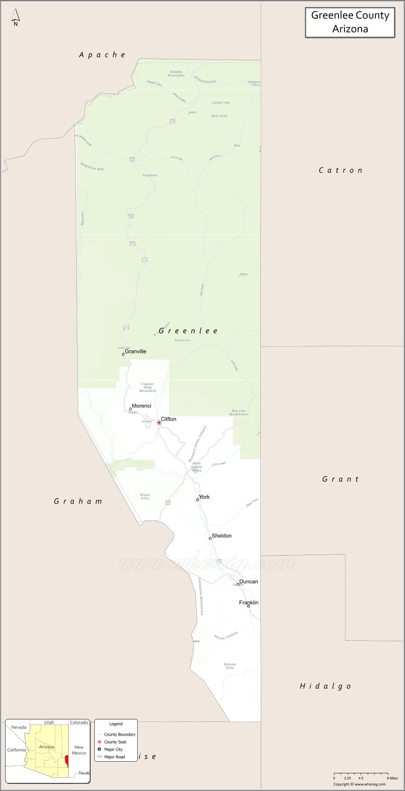
About Greenlee County Map, Arizona: The map showing the county boundary, county seat, major cities, highways, water bodies and neighbouring counties.
Most Viewed Arizona Maps
Map of Greenlee County, Arizona
Greenlee County is a county located in the U.S. state of Arizona. It's county seat is Clifton. As per 2020 census, the population of Greenlee County is 9404 people and population density is square miles. According to the United States Census Bureau, the county has a total area of 1,848 sq mi (4,786 km2). Greenlee County was established on 1909.
Greenlee County Facts
| County Info | Facts |
|---|---|
| County | Greenlee County |
| County Seat | Clifton |
| State | Arizona |
| Country | United States |
| FIPS code | 11 |
| Established | 1909 |
| Area | 1,848 sq mi (4,786 km2) |
| Population | 9404 |
| Density | |
| Formed / Origin | Graham County |
Ctities and Towns in Greenlee
| City Name | Type | Population (2020) | Pop. Density | Area | Incorporated |
|---|---|---|---|---|---|
| Clifton | Town | 3,933 | 269.0/sq mi (103.9/km2) | 14.62 sq mi (37.9 km2) | 1909 |
| Duncan | Town | 694 | 322.8/sq mi (124.6/km2) | 2.15 sq mi (5.6 km2) | 1938 |
Places to Visit in Greenlee
Top places to visit in london includes Blue Range Primitive Area, Round Mountain BLM Rockhound, Pumpkin Spring, Bear Wallow Wilderness, Guthrie Peak, Eagle Creek, Aker Lake, Ackre Lake, Apache-Sitgreaves National Forest, Gila Box Riparian National.
Highways in Greenlee
U.S. Route 70, U.S. Route 191, State Route 75, State Route 78.
Nearest Airports
Nearest airport of Greenlee is Asheville Regional Airport (AVL / KAVL).
- Alabama Counties
- Alaska boroughs
- Arizona Counties
- Arkansas Counties
- California County Map
- Colorado Counties
- Connecticut Counties
- Delaware Counties
- Florida County Map
- Georgia County Map
- Hawaii Counties
- Idaho Counties
- Illinois Counties
- Indiana Counties
- Iowa Counties
- Kansas Counties
- Kentucky Counties
- Louisiana Counties
- Maine Counties
- Maryland Counties
- Massachusetts Counties
- Michigan County Map
- Minnesota Counties
- Mississippi Counties
- Missouri Counties
- Montana Counties
- Nebraska Counties
- Nevada Counties
- New York Counties
- New Hampshire Counties
- New Jersey Counties
- New Mexico Counties
- North Carolina Counties
- North Dakota Counties
- Ohio County Map
- Oklahoma Counties
- Oregon Counties
- Pennsylvania Counties
- Rhode Island Counties
- South Carolina Counties
- South Dakota Counties
- Map of Tennessee
- Texas County Map
- Utah Counties
- Vermont Counties
- Virginia Counties
- Washington Counties
- West Virginia Counties
- Wisconsin Counties
- Wyoming Counties