Map of Mohave County - Mohave County is a county located in the U.S. state of Arizona. Mohave County Map showing cities, highways, important places and water bodies. Get Where is Mohave County located in the map, major cities in Mohave county, population, areas, and places of interest.
Mohave County Map, Arizona
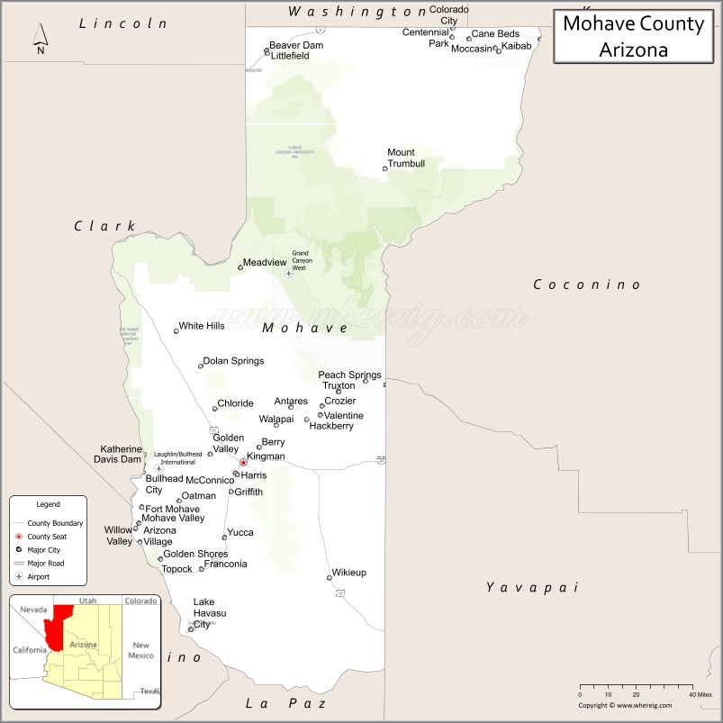
About Mohave County Map, Arizona: The map showing the county boundary, county seat, major cities, highways, water bodies and neighbouring counties.
Most Viewed Arizona Maps
Map of Mohave County, Arizona
Mohave County is a county located in the U.S. state of Arizona. It's county seat is Kingman. As per 2020 census, the population of Mohave County is 217692 people and population density is square miles. According to the United States Census Bureau, the county has a total area of 13,470 sq mi (34,887 km2). Mohave County was established on 1864.
Mohave County Facts
| County Info | Facts |
|---|---|
| County | Mohave County |
| County Seat | Kingman |
| State | Arizona |
| Country | United States |
| FIPS code | 15 |
| Established | 1864 |
| Area | 13,470 sq mi (34,887 km2) |
| Population | 217692 |
| Density | |
| Formed / Origin | ? |
Ctities and Towns in Mohave
| City Name | Type | Population (2020) | Pop. Density | Area | Incorporated |
|---|---|---|---|---|---|
| Bullhead City | City | 41,348 | 696.4/sq mi (268.9/km2) | 59.37 sq mi (153.8 km2) | 1984 |
| Colorado City | Town | 2,478 | 269.3/sq mi (104.0/km2) | 9.2 sq mi (23.8 km2) | 1985 |
| Kingman | City | 32,689 | 870.5/sq mi (336.1/km2) | 37.55 sq mi (97.3 km2) | 1952 |
| Lake Havasu City | City | 57,144 | 1,233.1/sq mi (476.1/km2) | 46.34 sq mi (120 km2) | 1978 |
Places to Visit in Mohave
Top places to visit in london includes London Bridge, Lake Havasu State Park, Grand Canyon Skywalk, Grand Canyon West, Arizona Route 66 Museum, Cattail Cove State Park, Los Lagos Golf Club, London Bridge Beach, Lake Mead National Recreation Area, Grand Canyon National Park, Rotary Community Park & Playgrounds, Bullhead City Community Park, Bullhead City Rotary Park, Hualapai Mountain Park Campground, Locomotive Park, Pipe Spring National Monument, Grand Canyon-Parashant National, Site Six Launch Ramp, Davis Dam, Monolith Garden Trail, Keepers of the Wild Nature Park, Huukan Golf Club, Toroweap Overlook, SARA Park, Liberty Bell Arch, Emerald Cove, Metcalfe Park, Arizona Hot Spring Trailhead, Tinnell Memorial Skatepark, Vermilion Cliffs, Topock Gorge, Lava Falls Rapid, Arrastra Mountain Wilderness, Vulcan's Throne, Steamboat Cove.
Highways in Mohave
Interstate 15,Interstate 40, U.S. Route 66, U.S. Route 93, State Route 66, State Route 68, State Route 95.
Nearest Airports
Nearest airport of Mohave is Kingman Airport (IGM / KIGM).
- Alabama Counties
- Alaska boroughs
- Arizona Counties
- Arkansas Counties
- California County Map
- Colorado Counties
- Connecticut Counties
- Delaware Counties
- Florida County Map
- Georgia County Map
- Hawaii Counties
- Idaho Counties
- Illinois Counties
- Indiana Counties
- Iowa Counties
- Kansas Counties
- Kentucky Counties
- Louisiana Counties
- Maine Counties
- Maryland Counties
- Massachusetts Counties
- Michigan County Map
- Minnesota Counties
- Mississippi Counties
- Missouri Counties
- Montana Counties
- Nebraska Counties
- Nevada Counties
- New York Counties
- New Hampshire Counties
- New Jersey Counties
- New Mexico Counties
- North Carolina Counties
- North Dakota Counties
- Ohio County Map
- Oklahoma Counties
- Oregon Counties
- Pennsylvania Counties
- Rhode Island Counties
- South Carolina Counties
- South Dakota Counties
- Map of Tennessee
- Texas County Map
- Utah Counties
- Vermont Counties
- Virginia Counties
- Washington Counties
- West Virginia Counties
- Wisconsin Counties
- Wyoming Counties