Map of Yuma County - Yuma County is a county located in the U.S. state of Arizona. Yuma County Map showing cities, highways, important places and water bodies. Get Where is Yuma County located in the map, major cities in Yuma county, population, areas, and places of interest.
Yuma County Map, Arizona
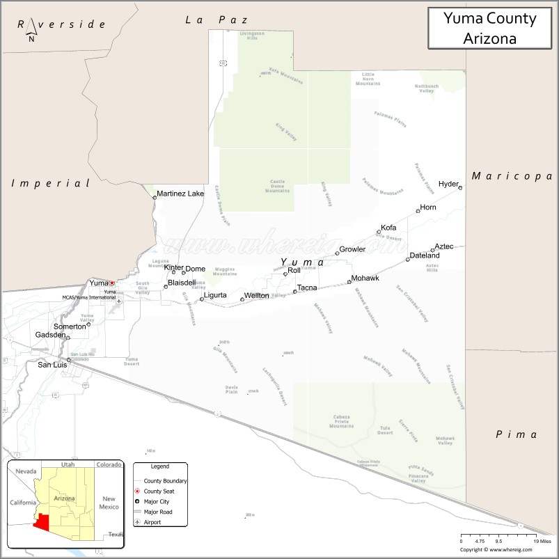
About Yuma County Map, Arizona: The map showing the county boundary, county seat, major cities, highways, water bodies and neighbouring counties.
Most Viewed Arizona Maps
Map of Yuma County, Arizona
Yuma County is a county located in the U.S. state of Arizona. It's county seat is Yuma. As per 2020 census, the population of Yuma County is 206990 people and population density is square miles. According to the United States Census Bureau, the county has a total area of 5,519 sq mi (14,294 km2). Yuma County was established on 1864.
Yuma County Facts
| County Info | Facts |
|---|---|
| County | Yuma County |
| County Seat | Yuma |
| State | Arizona |
| Country | United States |
| FIPS code | 27 |
| Established | 1864 |
| Area | 5,519 sq mi (14,294 km2) |
| Population | 206990 |
| Density | |
| Formed / Origin | ? |
Ctities and Towns in Yuma
| City Name | Type | Population (2020) | Pop. Density | Area | Incorporated |
|---|---|---|---|---|---|
| San Luis | City | 35,257 | 1,036.1/sq mi (400.0/km2) | 34.03 sq mi (88.1 km2) | 1979 |
| Somerton | City | 14,197 | 1,952.8/sq mi (754.0/km2) | 7.27 sq mi (18.8 km2) | 1918 |
| Wellton | Town | 2,375 | 82.2/sq mi (31.8/km2) | 28.88 sq mi (74.8 km2) | 1970 |
| Yuma | City | 95,548 | 791.8/sq mi (305.7/km2) | 120.67 sq mi (312.5 km2) | 1914 |
Places to Visit in Baldwin
Top places to visit in london includes Yuma Territorial Prison State Historic, West Wetlands Park, Gateway Park, Martha's Gardens, Colorado River State Historic Park, Yuma Crossing National Heritage, Kofa National Wildlife Refuge, Ocean to Ocean Highway Bridge, Jet Rent, Kennedy Memorial Park, Kofa National Wildlife Refuge, Martinez Lake, Mittry Lake, Sunrise Point Park.
Highways in Baldwin
Interstate 8, Historic U.S. Route 80, U.S. Route 95, Arizona State Route 195.
Nearest Airports
Nearest airport of Baldwin is Yuma International Airport.
- Alabama Counties
- Alaska boroughs
- Arizona Counties
- Arkansas Counties
- California County Map
- Colorado Counties
- Connecticut Counties
- Delaware Counties
- Florida County Map
- Georgia County Map
- Hawaii Counties
- Idaho Counties
- Illinois Counties
- Indiana Counties
- Iowa Counties
- Kansas Counties
- Kentucky Counties
- Louisiana Counties
- Maine Counties
- Maryland Counties
- Massachusetts Counties
- Michigan County Map
- Minnesota Counties
- Mississippi Counties
- Missouri Counties
- Montana Counties
- Nebraska Counties
- Nevada Counties
- New York Counties
- New Hampshire Counties
- New Jersey Counties
- New Mexico Counties
- North Carolina Counties
- North Dakota Counties
- Ohio County Map
- Oklahoma Counties
- Oregon Counties
- Pennsylvania Counties
- Rhode Island Counties
- South Carolina Counties
- South Dakota Counties
- Map of Tennessee
- Texas County Map
- Utah Counties
- Vermont Counties
- Virginia Counties
- Washington Counties
- West Virginia Counties
- Wisconsin Counties
- Wyoming Counties