Map of Pinal County - Pinal County is a county located in the U.S. state of Arizona. Pinal County Map showing cities, highways, important places and water bodies. Get Where is Pinal County located in the map, major cities in Pinal county, population, areas, and places of interest.
Pinal County Map, Arizona
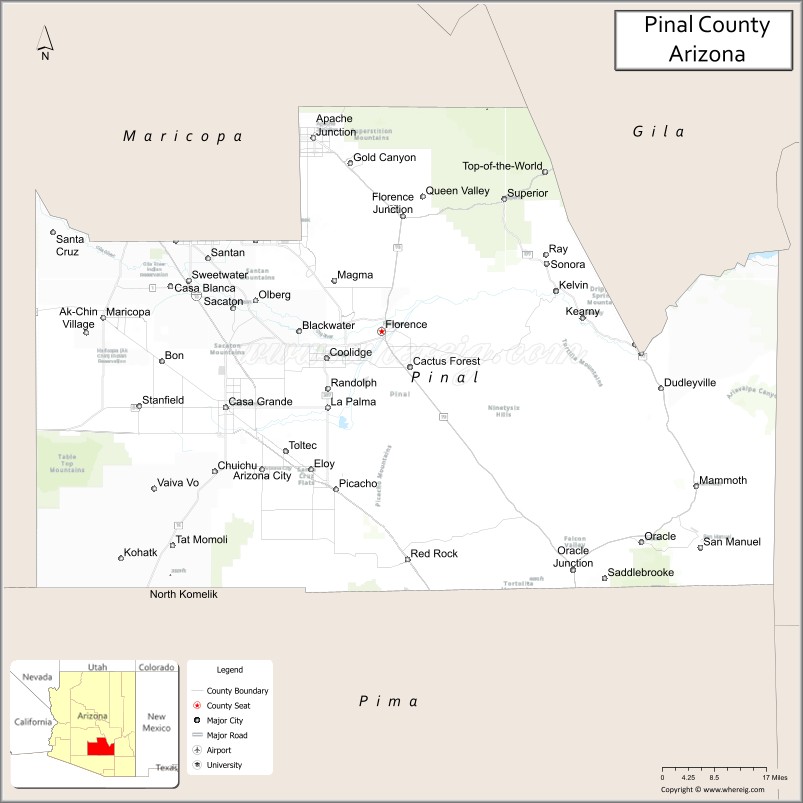
About Pinal County Map, Arizona: The map showing the county boundary, county seat, major cities, highways, water bodies and neighbouring counties.
Most Viewed Arizona Maps
Map of Pinal County, Arizona
Pinal County is a county located in the U.S. state of Arizona. It's county seat is Florence. As per 2020 census, the population of Pinal County is 449557 people and population density is square miles. According to the United States Census Bureau, the county has a total area of 5,374 sq mi (13,919 km2). Pinal County was established on 1875.
Pinal County Facts
| County Info | Facts |
|---|---|
| County | Pinal County |
| County Seat | Florence |
| State | Arizona |
| Country | United States |
| FIPS code | 21 |
| Established | 1875 |
| Area | 5,374 sq mi (13,919 km2) |
| Population | 449557 |
| Density | |
| Formed / Origin | Maricopa and Pima counties |
Ctities and Towns in Pinal
| City Name | Type | Population (2020) | Pop. Density | Area | Incorporated |
|---|---|---|---|---|---|
| Apache Junction | City | 38,499 | 1,097.8/sq mi (423.9/km2) | 35.07 sq mi (90.8 km2) | 1978 |
| Casa Grande | City | 53,658 | 484.0/sq mi (186.9/km2) | 110.87 sq mi (287.2 km2) | 1915 |
| Coolidge | City | 13,218 | 173.3/sq mi (66.9/km2) | 76.27 sq mi (197.5 km2) | 1945 |
| Eloy | City | 15,635 | 137.7/sq mi (53.2/km2) | 113.57 sq mi (294.1 km2) | 1949 |
| Florence | Town | 26,785 | 427.7/sq mi (165.2/km2) | 62.62 sq mi (162.2 km2) | 1908 |
| Kearny | Town | 1,741 | 644.8/sq mi (249.0/km2) | 2.7 sq mi (7 km2) | 1959 |
| Mammoth | Town | 1,076 | 40.9/sq mi (15.8/km2) | 26.32 sq mi (68.2 km2) | 1958 |
| Maricopa | City | 58,125 | 1,368.9/sq mi (528.5/km2) | 42.46 sq mi (110 km2) | 2003 |
| Superior | Town | 2,407 | 1,228.1/sq mi (474.2/km2) | 1.96 sq mi (5.1 km2) | 1976 |
Places to Visit in Pinal
Top places to visit in london includes Boyce Thompson Arboretum, Biosphere 2, Rooster Cogburn Ostrich Ranch, Casa Grande Ruins National Monument, Lost Dutchman State Park, Peralta Trailhead, Superstition Mountain - Lost, .
Highways in Pinal
Interstate 8, Interstate 10, U.S. Route 60, Historic U.S. Route 80, State Route 77, State Route 79, State Route 84, State Route 87, State Route 177, State Route 187, State Route 238, State Route 287, State Route 347, State Route 387, State Route 587.
Nearest Airports
Nearest airport of Pinal is Phoenix esa Gateway (AZA) Airport.
- Alabama Counties
- Alaska boroughs
- Arizona Counties
- Arkansas Counties
- California County Map
- Colorado Counties
- Connecticut Counties
- Delaware Counties
- Florida County Map
- Georgia County Map
- Hawaii Counties
- Idaho Counties
- Illinois Counties
- Indiana Counties
- Iowa Counties
- Kansas Counties
- Kentucky Counties
- Louisiana Counties
- Maine Counties
- Maryland Counties
- Massachusetts Counties
- Michigan County Map
- Minnesota Counties
- Mississippi Counties
- Missouri Counties
- Montana Counties
- Nebraska Counties
- Nevada Counties
- New York Counties
- New Hampshire Counties
- New Jersey Counties
- New Mexico Counties
- North Carolina Counties
- North Dakota Counties
- Ohio County Map
- Oklahoma Counties
- Oregon Counties
- Pennsylvania Counties
- Rhode Island Counties
- South Carolina Counties
- South Dakota Counties
- Map of Tennessee
- Texas County Map
- Utah Counties
- Vermont Counties
- Virginia Counties
- Washington Counties
- West Virginia Counties
- Wisconsin Counties
- Wyoming Counties