Map of Apache County - Apache County is a county located in the U.S. state of Arizona. Apache County Map showing cities, highways, important places and water bodies. Get Where is Apache County located in the map, major cities in Apache county, population, areas, and places of interest.
Apache County Map, Arizona
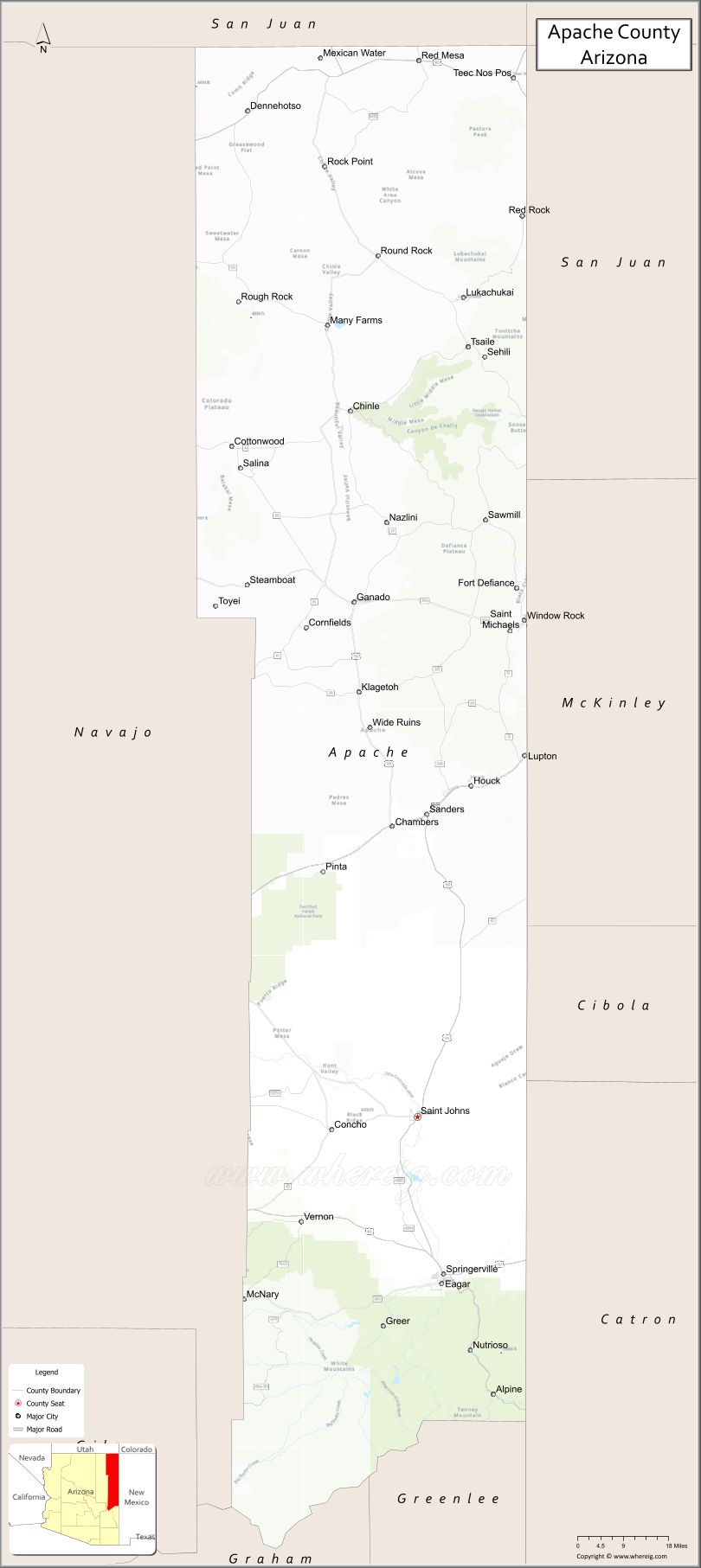
About Apache County Map, Arizona: The map showing the county boundary, county seat, major cities, highways, water bodies and neighbouring counties.
Most Viewed Arizona Maps
Map of Apache County, Arizona
Apache County is a county located in the U.S. state of Arizona. It's county seat is St. Johns. As per 2020 census, the population of Apache County is 65623 people and population density is square miles. According to the United States Census Bureau, the county has a total area of 11,218 sq mi (29,054 km2). Apache County was established on 1879.
Apache County Facts
| County Info | Facts |
|---|---|
| County | Apache County |
| County Seat | St. Johns |
| State | Arizona |
| Country | United States |
| FIPS code | 1 |
| Established | 1879 |
| Area | 11,218 sq mi (29,054 km2) |
| Population | 65623 |
| Density | |
| Formed / Origin | Yavapai County |
Ctities and Towns in Apache
| City Name | Type | Population (2020) | Pop. Density | Area | Incorporated |
|---|---|---|---|---|---|
| Eagar | Town | 4,395 | 379.5/sq mi (146.5/km2) | 11.58 sq mi (30 km2) | 1948 |
| Springerville | Town | 1,717 | 149.3/sq mi (57.6/km2) | 11.5 sq mi (29.8 km2) | 1948 |
| St. Johns | City | 3,417 | 131.9/sq mi (50.9/km2) | 25.91 sq mi (67.1 km2) | 1946 |
Places to Visit in Apache
Top places to visit in london includes Lost Dutchman State Park, Siphon Draw Trailhead, Treasure Loop Trail, Superstition Mountain - Lost,Goldfield Ghost Town and Mine.
Highways in Apache
Interstate 40, U.S. Route 60, U.S. Route 64, U.S. Route 180, U.S. Route 191, State Route 61, State Route 260, State Route 264.
Nearest Airports
Nearest airport of Apache is Chinle Municipal Airport.
- Alabama Counties
- Alaska boroughs
- Arizona Counties
- Arkansas Counties
- California County Map
- Colorado Counties
- Connecticut Counties
- Delaware Counties
- Florida County Map
- Georgia County Map
- Hawaii Counties
- Idaho Counties
- Illinois Counties
- Indiana Counties
- Iowa Counties
- Kansas Counties
- Kentucky Counties
- Louisiana Counties
- Maine Counties
- Maryland Counties
- Massachusetts Counties
- Michigan County Map
- Minnesota Counties
- Mississippi Counties
- Missouri Counties
- Montana Counties
- Nebraska Counties
- Nevada Counties
- New York Counties
- New Hampshire Counties
- New Jersey Counties
- New Mexico Counties
- North Carolina Counties
- North Dakota Counties
- Ohio County Map
- Oklahoma Counties
- Oregon Counties
- Pennsylvania Counties
- Rhode Island Counties
- South Carolina Counties
- South Dakota Counties
- Map of Tennessee
- Texas County Map
- Utah Counties
- Vermont Counties
- Virginia Counties
- Washington Counties
- West Virginia Counties
- Wisconsin Counties
- Wyoming Counties