
Where is Broomfield Located? - Broomfield is a city located in the Broomfield[b] County of Colorado, United States. Broomfield lies between 39.92451 Degrees North latitudes and -105.061 Degrees West longitudes.
Location Map of Broomfield, Colorado
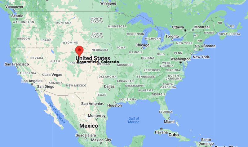
Broomfield Map, Colorado, USA
Where is Broomfield?: The Google Map showing the location of Broomfield in the U.S. state of Colorado.
Where is Broomfield Located?
Broomfield is a city located in the Broomfield County of Colorado, United States. Broomfield lies between 39.92451 Degrees North latitude and -105.061 Degrees West longitude. According to the 2020 U.S. Census, the population of Broomfield city is 74,112 people and the city has a total area of 33.548 sq mi. The city has numerous parks and recreational facilities.
Most Viewed US Maps
| USA Sttae Map | USA Region Map | USA Road Map |
| USA County Map | Where is USA in World Map? | US ZIP Code Map |
| USA Time Zones Map | US State and Capitals Map | USA Physical Map |
Find 4,400+ U.S. Cities by State - Explore Their Locations and Get Detailed Information
Broomfield, Colorado Quick Facts
| Fact | Details |
|---|---|
| City | Broomfield |
| County | Broomfield County |
| State | Colorado |
| Country | United States |
| Region | Front Range Colorado |
| Metro Area | Denver–Aurora–Lakewood Metropolitan Area |
| Established | 1877 |
| Incorporated | 1961 |
| 2020 Census Population | 74,112 |
| Total Area | 33.548 sq mi (86.89 sq km) |
| Population Density | 2,248 people per sq mi |
| Latitude | 39.92451 |
| Longitude | -105.061 |
| FIPS Code | 0809280 |
| County FIPS | 08014 |
| ZIP Code | 80020, 80021, 80023, 80026, 80027, 80234, 80516 |
| Area Code | 303, 720 |
| Time Zone | Mountain Time (MT) (UTC−7/UTC−6) |
| Major Highways | U.S. Highway 36, U.S. Highway 287, State Highway 7, State Highway 121, State Highway 128, E-470/Northwest Parkway |
| Public Transit | Regional Transportation District (RTD) |
| School District | Adams 12 Five Star Schools, Boulder Valley School District, Jefferson County School District R-1, St. Vrain Valley Schools |
| Nearby Major City | Denver |
| Airport | Rocky Mountain Metropolitan Airport (BJC) |
| Major Attractions | Broomfield County Commons, The Field Open Space, Brunner Farmhouse, Broomfield Bay Aquatic Park |
| Official Website | City and County of Broomfield |
Nearby Cities to Broomfield, Colorado
- Westminster, Colorado - 4 mi Southeast
- Louisville, Colorado - 6 mi Northwest
- Lafayette, Colorado - 8 mi North
- Thornton, Colorado - 9 mi East
- Northglenn, Colorado - 10 mi East
- Arvada, Colorado - 10 mi South
- Boulder, Colorado - 13 mi Northwest
- Superior, Colorado - 7 mi West
- Denver, Colorado - 18 mi Southeast
- Longmont, Colorado - 22 mi North
Driving Distances from Broomfield, Colorado
| City | State | Distance (mi) | Approx. Drive Time |
|---|---|---|---|
| Westminster | Colorado | 4 | 10 min |
| Louisville | Colorado | 6 | 12 min |
| Boulder | Colorado | 13 | 20 min |
| Thornton | Colorado | 9 | 15 min |
| Arvada | Colorado | 10 | 18 min |
| Denver | Colorado | 18 | 25 min |
| Golden | Colorado | 20 | 30 min |
| Longmont | Colorado | 22 | 30 min |
| Aurora | Colorado | 28 | 35 min |
| Fort Collins | Colorado | 55 | 1 hr |
Transportation and Connectivity in Broomfield, Colorado
| Transportation | Details |
|---|---|
| Airport Name | Rocky Mountain Metropolitan Airport |
| IATA Code | BJC |
| Port | Not Applicable |
| Major Highways | US 36, SH 121, SH 128, SH 287, E-470 (nearby) |
| Train/Amtrak Service | No local Amtrak station; nearest service at Denver Union Station |
| Local Bus/Transit Service | Regional Transportation District (RTD) |
- US 36 - Principal highway connecting Broomfield with Denver and Boulder.
- Colorado State Highway 121 (Wadsworth Parkway) - Major north-south route serving western suburbs.
- Colorado State Highway 128 - Connects Broomfield with Interlocken, Louisville and US 36.
- Colorado State Highway 287 - Links the city with Lafayette, Longmont and Denver metropolitan communities.
- E-470 - Toll highway located east of the city providing access to Denver International Airport and eastern suburbs.
Key Landmarks and Places to Visit in Broomfield, Colorado
| Landmark Name | Type |
|---|---|
| FlatIron Crossing | Shopping Center |
| Broomfield County Commons Park | Park |
| Butterfly Pavilion | Nature Center |
| 1stBank Center | Entertainment Venue |
| Paul Derda Recreation Center | Recreation Center |
| Broomfield Veterans Memorial Museum | Museum |
| Carolyn Holmberg Preserve at Rock Creek Farm | Nature Preserve |
| Stearns Lake | Nature Area |
| Westminster Hills Open Space | Open Space Park |
| Interlocken Business Park | Business District |
Colleges and Universities in Broomfield, Colorado
| Institution Name | Type | Level | Notable For |
|---|---|---|---|
| Front Range Community College - Westminster Campus | Public | Community College | Career and transfer programs |
| University of Colorado Boulder | Public | University | Flagship research university |
| Naropa University | Private | University | Liberal arts education |
| Regis University - Broomfield Campus | Private | University | Adult and professional studies |
| Broomfield High School | Public | K-12 District | Secondary education |
Waterbodies in Broomfield, Colorado
Stearns Lake, McKay Lake, Great Western Reservoir, Rock Creek, Big Dry Creek, Woman Creek, Standley Lake, Walnut Creek
Golf Courses in Broomfield, Colorado
Broadlands Golf Course, Eagle Trace Golf Club, Omni Interlocken Golf Club, Heritage at Westmoor Golf Club, Indian Peaks Golf Course, Hyland Hills Golf Course, Legacy Ridge Golf Course, Coal Creek Golf Course
Broomfield, Colorado - Key Historical Facts
- Broomfield was established in 1961 after residents voted to incorporate the growing suburban community.
- The city was originally divided among four counties before becoming Colorado's consolidated City and County of Broomfield in 2001.
- Broomfield experienced rapid growth during the late twentieth century because of its location between Denver and Boulder.
- The development of the Interlocken Business Park attracted major technology, aerospace, and financial companies to the area.
- Open space preservation has remained an important part of the city's planning, with numerous parks and trails protecting natural landscapes.
- Today, Broomfield is recognized for its strong economy, family-friendly neighborhoods, and convenient access to both the Rocky Mountains and the Denver metropolitan area.
References
- U.S. Census Bureau
- City and County of Broomfield
- Colorado Department of Transportation
- National Weather Service
Colorado Maps and Info
- Where is Arvada
- Where is Black Forest
- Where is Boulder
- Where is Brighton
- Where is Broomfield
- Where is Castle Rock
- Where is Centennial
- Where is Cimarron Hills
- Where is Clifton
- Where is Columbine
- Where is Commerce City
- Where is Dakota Ridge
- Where is Durango
- Where is Englewood
- Where is Erie
- Where is Evans
- Where is Firestone
- Where is Fort Carson
- Where is Fort Collins
- Where is Fountain
- Where is Frederick
- Where is Golden
- Where is Grand Junction
- Where is Greeley
- Where is Greenwood Village
- Where is Highlands Ranch
- Where is Johnstown
- Where is Ken Caryl
- Where is Lafayette
- Where is Lakewood
- Where is Littleton
- Where is Lone Tree
- Where is Longmont
- Where is Loveland
- Where is Montrose
- Where is Northglenn
- Where is Parker
- Where is Pueblo
- Where is Pueblo West
- Where is Security-Widefield
- Where is Sherrelwood
- Where is Thornton
- Where is Welby
- Where is Westminster
- Where is Wheat Ridge
- Where is Windsor