
Where is Evans Located? - Evans is a city located in the Weld County of Colorado, United States. Evans lies between 41.2841 Degrees North latitudes and 73.4975 Degrees West longitudes.
Location Map of Evans, Colorado
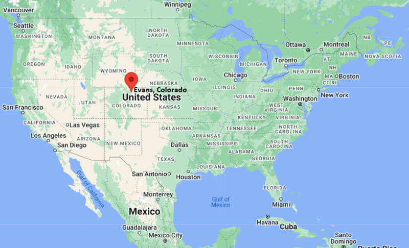
Evans Map, Colorado, USA
Where is Evans?: The Google Map showing the location of Evans in the U.S. state of Colorado.
Where is Evans Located?
Evans is a city located in the Weld County of Colorado, United States. Evans lies between 41.2841 Degrees North latitudes and 73.4975 Degrees West longitudes. According to 2020 U.S.census, the population of Evans city is 22165 people and the city has a total area of 10.18 sq mi. The city has numerous parks and recreational facilities.
Most Viewed US Maps
| USA Sttae Map | USA Region Map | USA Road Map |
| USA County Map | Where is USA in World Map? | US ZIP Code Map |
| USA Time Zones Map | US State and Capitals Map | USA Physical Map |
Find 4,400+ U.S. Cities by State - Explore Their Locations and Get Detailed Information
Evans, Colorado Quick Facts
| Property | Details |
|---|---|
| City | Evans |
| County | Weld County |
| State | Colorado |
| State Capital | Denver |
| US Region | West |
| Latitude | 40.3764°N |
| Longitude | 104.6922°W |
| Elevation | ~4,590 ft (1,399 m) |
| Land Area | Approx. 7.5 sq mi |
| Water Area | Approx. 0.1 sq mi |
| Total Area | Approx. 7.6 sq mi |
| Population (2020 Census) | ~22,000 |
| Population Density | Approximately 2,900 per sq mi |
| ZIP Codes | 80620 |
| Area Code | 970 |
| Time Zone Standard | Mountain Standard Time (MST), UTC−7 |
| Time Zone Daylight | Mountain Daylight Time (MDT), UTC−6 |
| Currency | US Dollar (USD) |
| FIPS Code | 08-24615 |
| Congressional District | Colorado's 4th Congressional District |
Nearby Cities to Evans, Colorado
- Greeley, Colorado - North - 3 mi
- Garden City, Colorado - North - 2 mi
- Windsor, Colorado - West - 12 mi
- Severance, Colorado - West - 10 mi
- Fort Collins, Colorado - Northwest - 25 mi
- Loveland, Colorado - Southwest - 28 mi
- Longmont, Colorado - South - 35 mi
- Brighton, Colorado - South - 40 mi
- Denver, Colorado - South - 50 mi
- Boulder, Colorado - Southwest - 55 mi
Evans, Colorado Climate and Weather Overview
| Month | Avg High (°F) | Avg Low (°F) | Avg Rainfall (in) |
|---|---|---|---|
| January | 43 | 15 | 0.5 |
| April | 63 | 34 | 1.2 |
| July | 90 | 58 | 1.4 |
| October | 66 | 36 | 0.8 |
| Annual | 65 | 35 | ~15.0 |
| Climate Attribute | Details |
|---|---|
| Climate Classification (Köppen) | Semi-arid / cold steppe (BSk) |
| Annual Rainfall | About 15 inches |
| Summer Conditions | Hot days, cool nights |
| Winter Conditions | Cold with occasional snow |
| Severe Weather Risk | Thunderstorms, hail, occasional tornado influence nearby |
Driving Distances from Evans, Colorado
| City | State | Distance (mi) | Approx. Drive Time |
|---|---|---|---|
| Greeley | Colorado | 3 | 8 min |
| Garden City | Colorado | 2 | 5 min |
| Windsor | Colorado | 12 | 20 min |
| Severance | Colorado | 10 | 15–18 min |
| Fort Collins | Colorado | 25 | 30–35 min |
| Loveland | Colorado | 28 | 35 min |
| Longmont | Colorado | 35 | 45 min |
| Boulder | Colorado | 55 | 1 hr 5 min |
| Denver | Colorado | 50 | 55 min |
| Brighton | Colorado | 40 | 45 min |
Transportation and Connectivity in Evans, Colorado
| Transportation | Details |
|---|---|
| Airport Name | Denver International Airport |
| IATA Code | DEN |
| Regional Airport | Northern Colorado Regional Airport (Loveland) |
| Major Highways | U.S. Route 85, U.S. Route 34, State Highway 392 |
| Rail Service | No direct Amtrak station in Evans (nearest: Denver) |
| Local Transit | Greeley-Evans Transit (GET) |
- Evans is part of the Greeley metropolitan area in northern Colorado.
- The city is strongly tied to agriculture, energy, and regional commuting patterns.
- U.S. Route 85 connects Evans to Denver and Wyoming.
- Rapid suburban growth has expanded residential and commercial development in recent decades.
Places to Visit in Evans, Colorado
| Landmark Name | Type |
|---|---|
| Evans City Park | Community Park |
| Greeley Family FunPlex | Recreation Center |
| Poudre River Trail | Scenic Trail |
| Island Grove Regional Park | Event & Fairgrounds |
| Centennial Village Museum | History Museum |
| Greeley History Museum | Museum |
| Bittersweet Park | City Park |
| Chimney Park Reservoir | Reservoir & Recreation Area |
| Promontory Park | Neighborhood Park |
| Colorado Model Railroad Museum | Museum |
Colleges and Universities in Evans, Colorado
| Institution Name | Type | Level | Notable For |
|---|---|---|---|
| University of Northern Colorado | Public | University | Education, nursing, business, performing arts |
| Aims Community College | Public | Community College | Workforce training, aviation, technical programs |
| Colorado State University | Public | University | Engineering, agriculture, veterinary medicine |
| Front Range Community College | Public | Community College | Transfer and career programs |
| Metropolitan State University of Denver | Public | University | Business, aviation, arts |
| University of Colorado Boulder | Public | University | Engineering, science, research |
| Greeley-Evans School District 6 | Public | K–12 District | Primary and secondary education |
| Weld County School District RE-3J | Public | K–12 District | Regional schooling system |
Waterbodies in Evans, Colorado
South Platte River, Cache la Poudre River, Poudre River Trail waterways, Union Reservoir (nearby), Boyd Lake (regional), St. Vrain Creek, Big Thompson River, Windsor Lake
Golf Courses in Evans, Colorado
Mad Russian Golf Club, Highland Hills Golf Course, Boomerang Links, Pelican Lakes Golf Club, Greeley Country Club, Fox Hill Club (nearby), TPC Colorado (regional), Mariana Butte Golf Course
Evans, Colorado — Key Historical Facts
- Evans was founded in the late 19th century as a railroad and agricultural supply town.
- The city was named after John Evans, the second governor of the Colorado Territory.
- Early development centered around farming, irrigation, and the South Platte River valley.
- The arrival of rail infrastructure helped connect Evans to regional markets.
- Post-World War II growth turned Evans into a residential suburb of Greeley.
- Today, Evans is part of a growing northern Colorado metro area with strong ties to agriculture and energy industries.
References
Colorado Maps and Info
- Where is Arvada
- Where is Black Forest
- Where is Boulder
- Where is Brighton
- Where is Broomfield
- Where is Castle Rock
- Where is Centennial
- Where is Cimarron Hills
- Where is Clifton
- Where is Columbine
- Where is Commerce City
- Where is Dakota Ridge
- Where is Durango
- Where is Englewood
- Where is Erie
- Where is Evans
- Where is Firestone
- Where is Fort Carson
- Where is Fort Collins
- Where is Fountain
- Where is Frederick
- Where is Golden
- Where is Grand Junction
- Where is Greeley
- Where is Greenwood Village
- Where is Highlands Ranch
- Where is Johnstown
- Where is Ken Caryl
- Where is Lafayette
- Where is Lakewood
- Where is Littleton
- Where is Lone Tree
- Where is Longmont
- Where is Loveland
- Where is Montrose
- Where is Northglenn
- Where is Parker
- Where is Pueblo
- Where is Pueblo West
- Where is Security-Widefield
- Where is Sherrelwood
- Where is Thornton
- Where is Welby
- Where is Westminster
- Where is Wheat Ridge
- Where is Windsor