
Where is Montrose Located? - Montrose is a city located in the Montrose County seat County of Colorado, United States. Montrose lies between 41.5770 Degrees North latitudes and 73.4085 Degrees West longitudes.
Location Map of Montrose, Colorado
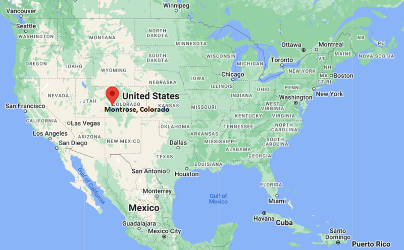
Montrose Map, Colorado, USA
Where is Montrose?: The Google Map showing the location of Montrose in the U.S. state of Colorado.
Where is Montrose Located?
Montrose is a city located in the Montrose County seat County of Colorado, United States. Montrose lies between 41.5770 Degrees North latitudes and 73.4085 Degrees West longitudes. According to 2020 U.S.census, the population of Montrose city is 20291 people and the city has a total area of 18.45 sq mi. The city has numerous parks and recreational facilities.
Most Viewed US Maps
| USA Sttae Map | USA Region Map | USA Road Map |
| USA County Map | Where is USA in World Map? | US ZIP Code Map |
| USA Time Zones Map | US State and Capitals Map | USA Physical Map |
Find 4,400+ U.S. Cities by State - Explore Their Locations and Get Detailed Information
Montrose, Colorado Quick Facts
| Attribute | Information |
|---|---|
| City | Montrose |
| County | Montrose County |
| State | Colorado |
| State Capital | Denver |
| US Region | Mountain West |
| Latitude | 38.4783° N |
| Longitude | 107.8762° W |
| Elevation | 5,807 ft (1,770 m) |
| Land Area | 18.53 sq mi |
| Water Area | 0.03 sq mi |
| Total Area | 18.56 sq mi |
| Population (2020 Census) | 20,291 |
| Population Density | Approximately 1,095 per sq mi |
| ZIP Codes | 81401, 81403 |
| Area Code | 970 |
| Time Zone Standard | Mountain Standard Time (MST, UTC−7) |
| Time Zone Daylight | Mountain Daylight Time (MDT, UTC−6) |
| Currency | United States Dollar (USD) |
| FIPS Code | 08-51675 |
| Congressional District | Colorado's 3rd Congressional District |
Transportation and Connectivity in Montrose
| Category | Information |
|---|---|
| Airport Name | Montrose Regional Airport |
| IATA Code | MTJ |
| Port | Not applicable |
| Major Highways | U.S. Highway 50, U.S. Highway 550, Colorado State Highway 90 |
| Train/Amtrak Service | No passenger rail service; nearest Amtrak access is Grand Junction |
| Local Bus/Transit Service | Montrose Public Transportation and regional transit services |
- U.S. Highway 50 – Major east–west route connecting Montrose with Gunnison, Grand Junction, and western Colorado communities.
- U.S. Highway 550 – Scenic highway connecting Montrose with Ouray, Silverton, and Durango.
- Colorado State Highway 90 – Regional route providing access to nearby rural communities.
- South Townsend Avenue – Main commercial corridor through the city.
Top Places to Visit in Montrose, Colorado
| Landmark Name | Type |
|---|---|
| Black Canyon of the Gunnison National Park | National Park |
| Ute Indian Museum | Museum |
| Montrose Botanic Gardens | Botanical Garden |
| Riverbottom Park | Park |
| Baldridge Park | Park |
| Ute Museum Garden | Cultural Attraction |
| South Rim of Black Canyon | Natural Attraction |
| Montrose County Historical Museum | Museum |
| Escalante Canyon | Natural Area |
| Ridgway State Park | State Park |
Driving Distances from Montrose, Colorado to Nearby Cities
| City | State | Distance (mi) | Approx. Drive Time |
|---|---|---|---|
| Delta | Colorado | 24 | 30 minutes |
| Ridgway | Colorado | 27 | 35 minutes |
| Ouray | Colorado | 37 | 45 minutes |
| Grand Junction | Colorado | 63 | 1 hour 15 minutes |
| Gunnison | Colorado | 96 | 1 hour 50 minutes |
| Durango | Colorado | 100 | 2 hours |
| Telluride | Colorado | 65 | 1 hour 45 minutes |
| Colorado Springs | Colorado | 300 | 5 hours |
| Denver | Colorado | 290 | 5 hours |
| Salt Lake City | Utah | 320 | 5 hours |
Colleges and Universities in Montrose, Colorado
| Institution Name | Type | Level | Notable For |
|---|---|---|---|
| Colorado Mesa University – Montrose Campus | Public | University Campus | Higher education and workforce programs |
| Western Colorado University | Public | University | Environmental studies and outdoor programs |
| Colorado Mountain College | Public | Community College | Career and technical education |
| Pikes Peak State College | Public | College | Professional and academic programs |
| Colorado Mesa University | Public | University | Business, science, and liberal arts |
Waterbodies in Montrose, Colorado
Uncompahgre River, Cimarron River, Gunnison River, Ridgway Reservoir, Blue Mesa Reservoir, Crawford Reservoir, Horsefly Creek, Coal Creek.
Stadiums in Montrose
Montrose High School Stadium, Friendship Field, Cerise Park Sports Complex, Stocker Stadium, Community Recreation Center Fields.
Montrose, Colorado — Key Historical Facts
- Montrose was founded in 1882 and named after Sir Walter Scott's novel A Legend of Montrose.
- The city developed as an agricultural and transportation center in the Uncompahgre Valley after irrigation projects transformed the surrounding farmland.
- The arrival of the railroad in the late nineteenth century helped Montrose become an important regional trade center.
- Montrose served as a gateway community for visitors traveling to the Black Canyon of the Gunnison and the San Juan Mountains.
- Today, Montrose is known for agriculture, outdoor recreation, tourism, and its role as a regional service center in southwestern Colorado.
References
- City of Montrose
- Montrose County Government
- U.S. Census Bureau
- Colorado Mesa University
- Visit Montrose Colorado
Colorado Maps and Info
- Where is Arvada
- Where is Black Forest
- Where is Boulder
- Where is Brighton
- Where is Broomfield
- Where is Castle Rock
- Where is Centennial
- Where is Cimarron Hills
- Where is Clifton
- Where is Columbine
- Where is Commerce City
- Where is Dakota Ridge
- Where is Durango
- Where is Englewood
- Where is Erie
- Where is Evans
- Where is Firestone
- Where is Fort Carson
- Where is Fort Collins
- Where is Fountain
- Where is Frederick
- Where is Golden
- Where is Grand Junction
- Where is Greeley
- Where is Greenwood Village
- Where is Highlands Ranch
- Where is Johnstown
- Where is Ken Caryl
- Where is Lafayette
- Where is Lakewood
- Where is Littleton
- Where is Lone Tree
- Where is Longmont
- Where is Loveland
- Where is Montrose
- Where is Northglenn
- Where is Parker
- Where is Pueblo
- Where is Pueblo West
- Where is Security-Widefield
- Where is Sherrelwood
- Where is Thornton
- Where is Welby
- Where is Westminster
- Where is Wheat Ridge
- Where is Windsor