
Where is Fort Collins Located? - Fort Collins is a city located in the Larimer County seat County of Colorado, United States. Fort Collins lies between 41.6612 Degrees North latitudes and 72.7795 Degrees West longitudes.
Location Map of Fort Collins, Colorado
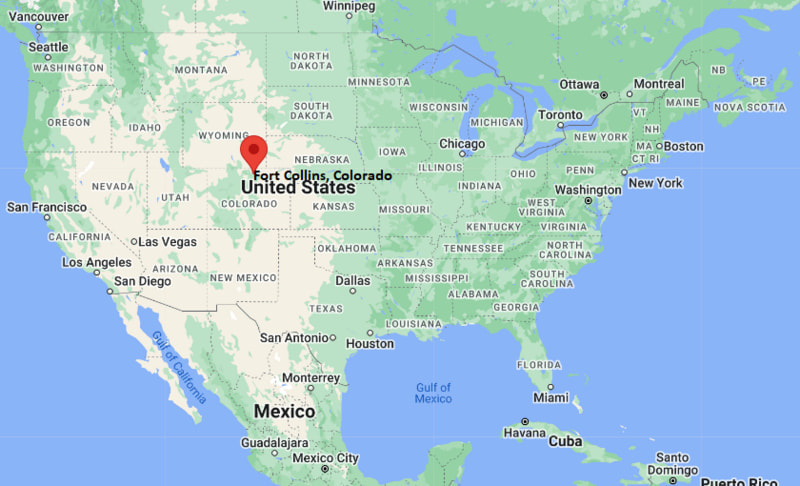
Fort Collins Map, Colorado, USA
Where is Fort Collins?: The Google Map showing the location of Fort Collins in the U.S. state of Colorado.
Where is Fort Collins Located?
Fort Collins is a city located in the Larimer County seat County of Colorado, United States. Fort Collins lies between 41.6612 Degrees North latitudes and 72.7795 Degrees West longitudes. According to 2020 U.S.census, the population of Fort Collins city is 169810 people and the city has a total area of 57.18 sq mi. The city has numerous parks and recreational facilities.
Most Viewed US Maps
| USA Sttae Map | USA Region Map | USA Road Map |
| USA County Map | Where is USA in World Map? | US ZIP Code Map |
| USA Time Zones Map | US State and Capitals Map | USA Physical Map |
Find 4,400+ U.S. Cities by State - Explore Their Locations and Get Detailed Information
Fort Collins, Colorado Quick Facts
| Property | Information |
|---|---|
| City | Fort Collins |
| County | Larimer County |
| State | Colorado |
| State Capital | Denver |
| US Region | Western United States |
| Latitude | 40.5853° N |
| Longitude | 105.0844° W |
| Elevation | 5,003 ft (1,525 m) |
| Land Area | 57.95 sq mi |
| Water Area | 1.67 sq mi |
| Total Area | 59.62 sq mi |
| Population (latest Census year) | 169,810 (2020 Census) |
| Population Density | 2,930 per sq mi |
| ZIP Codes | 80521, 80523, 80524, 80525, 80526, 80527, 80528 |
| Area Code | 970 |
| Time Zone Standard | Mountain Standard Time (MST, UTC−7) |
| Time Zone Daylight | Mountain Daylight Time (MDT, UTC−6) |
| Currency | US Dollar (USD) |
| FIPS Code | 08-27425 |
| Congressional District | 2nd Congressional District |
Nearby Cities to Fort Collins, Colorado
- Loveland, Colorado — 14 mi South
- Windsor, Colorado — 16 mi Southeast
- Timnath, Colorado — 8 mi East
- Wellington, Colorado — 10 mi North
- Laporte, Colorado — 5 mi Northwest
- Johnstown, Colorado — 27 mi Southeast
- Berthoud, Colorado — 27 mi South
- Greeley, Colorado — 31 mi East
- Longmont, Colorado — 42 mi South
- Cheyenne, Wyoming — 46 mi North
Driving Distances from Fort Collins, Colorado
| City | State | Distance (mi) | Approx. Drive Time |
|---|---|---|---|
| Laporte | Colorado | 5 | 10 min |
| Timnath | Colorado | 8 | 12 min |
| Wellington | Colorado | 10 | 15 min |
| Loveland | Colorado | 14 | 20 min |
| Windsor | Colorado | 16 | 22 min |
| Johnstown | Colorado | 27 | 30 min |
| Berthoud | Colorado | 27 | 32 min |
| Greeley | Colorado | 31 | 40 min |
| Cheyenne | Wyoming | 46 | 50 min |
| Denver | Colorado | 65 | 1 hr 10 min |
Transportation and Connectivity in Fort Collins, Colorado
| Category | Information |
|---|---|
| Airport Name | Northern Colorado Regional Airport (nearest); Denver International Airport (major airport) |
| IATA Code | FNL (Northern Colorado Regional), DEN (Denver International) |
| Port | Not applicable |
| Major Highways | Interstate 25, U.S. Route 287, Colorado State Highway 14, Colorado State Highway 1 |
| Train/Amtrak Service | No direct Amtrak service; nearest station is Denver (via Bustang connection) |
| Local Bus/Transit Service | Transfort, FLEX Regional Bus, Bustang |
- Interstate 25 provides direct access to Denver, Cheyenne, Colorado Springs, and other Front Range communities.
- U.S. Route 287 serves as the primary north-south highway through Fort Collins and connects with Wyoming and central Colorado.
- Colorado State Highway 14 links the city with Poudre Canyon, Roosevelt National Forest, and northeastern Colorado.
- Transfort and FLEX bus services provide public transportation throughout Fort Collins and neighboring communities including Loveland.
What are top Places to Visit in Fort Collins, Colorado
| Landmark Name | Type |
|---|---|
| Old Town Fort Collins | Historic District |
| Colorado State University | University Campus |
| Horsetooth Reservoir | Reservoir & Recreation Area |
| The Gardens on Spring Creek | Botanical Garden |
| Fort Collins Museum of Discovery | Museum |
| Lory State Park | State Park |
| Cache la Poudre River National Heritage Area | Scenic & Historic Area |
| New Belgium Brewing Company | Brewery |
| Odell Brewing Company | Brewery |
| Spring Canyon Community Park | Community Park |
Colleges and Universities in Fort Collins, Colorado
| Institution Name | Type | Level | Notable For |
|---|---|---|---|
| Colorado State University | Public | University | Research, veterinary medicine, engineering, agriculture and business |
| Front Range Community College – Larimer Campus | Public | Community College | Transfer programs, workforce training and technical education |
| Institute of Business & Medical Careers | Private | Career College | Healthcare and business education |
| Poudre School District | Public | K–12 District | Comprehensive public education serving Fort Collins and surrounding communities |
Waterbodies in Fort Collins, Colorado
Cache la Poudre River, Horsetooth Reservoir, Fossil Creek Reservoir, Warren Lake, Sheldon Lake, Dixon Reservoir, Prospect Ponds, Spring Canyon Reservoir
Golf Courses in Fort Collins, Colorado
Collindale Golf Course, Southridge Golf Course, City Park Nine Golf Course, Harmony Club Golf Course, Ptarmigan Country Club, Highland Meadows Golf Course
Fort Collins, Colorado — Key Historical Facts
- Fort Collins was established in 1864 as a U.S. Army military outpost to protect travelers along the Overland Trail and was named after Colonel William O. Collins.
- After the military post closed in the late nineteenth century, the community developed into an agricultural center supported by irrigation projects and farming in the Cache la Poudre Valley.
- The founding of Colorado Agricultural College in 1870, now Colorado State University, transformed Fort Collins into a leading center for higher education and research.
- The city's economy expanded throughout the twentieth century with growth in manufacturing, technology, brewing, and scientific research while preserving its historic downtown.
- Today, Fort Collins is one of Colorado's largest cities, recognized for its vibrant Old Town, outdoor recreation, thriving craft beer industry, Colorado State University, and high quality of life.
References
Colorado Maps and Info
- Where is Arvada
- Where is Black Forest
- Where is Boulder
- Where is Brighton
- Where is Broomfield
- Where is Castle Rock
- Where is Centennial
- Where is Cimarron Hills
- Where is Clifton
- Where is Columbine
- Where is Commerce City
- Where is Dakota Ridge
- Where is Durango
- Where is Englewood
- Where is Erie
- Where is Evans
- Where is Firestone
- Where is Fort Carson
- Where is Fort Collins
- Where is Fountain
- Where is Frederick
- Where is Golden
- Where is Grand Junction
- Where is Greeley
- Where is Greenwood Village
- Where is Highlands Ranch
- Where is Johnstown
- Where is Ken Caryl
- Where is Lafayette
- Where is Lakewood
- Where is Littleton
- Where is Lone Tree
- Where is Longmont
- Where is Loveland
- Where is Montrose
- Where is Northglenn
- Where is Parker
- Where is Pueblo
- Where is Pueblo West
- Where is Security-Widefield
- Where is Sherrelwood
- Where is Thornton
- Where is Welby
- Where is Westminster
- Where is Wheat Ridge
- Where is Windsor