Map of Larimer County - Larimer County is a county located in the U.S. state of Colorado. Larimer County Map showing cities, highways, important places and water bodies. Get Where is Larimer County located in the map, major cities in Larimer county, population, areas, and places of interest.
Map of Larimer County, Colorado
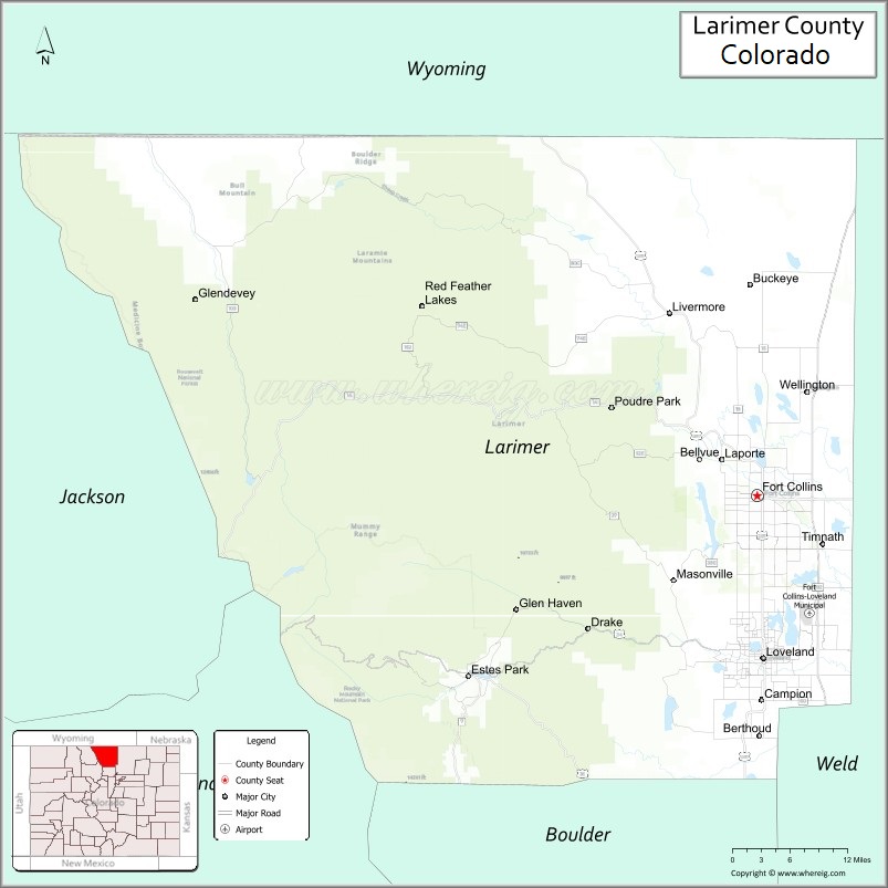
About Larimer County Map, Colorado: The map showing the county boundary, county seat, major cities, highways, water bodies and neighbouring counties.
Most Viewed Links
Map of Larimer County, Colorado
Larimer County is a county located in the U.S. state of Colorado. It's county seat is Fort Collins. As per 2020 census, the population of Larimer County is 362533 people and population density is square miles. According to the United States Census Bureau, the county has a total area of 2,631.75 sq mi (6,816 km2). Larimer County was established on -13938.
Larimer County Facts
| Continent | North America |
| Country | United States |
| State | Colorado |
| County Seat | Fort Collins |
| Largest City/Town | Fort Collins |
| Established | 1861 |
| Total Area | 2,640 sq mi (6,838 sq km) |
| Land Area | 2,596 sq mi (6,724 sq km) |
| Water Area | 44 sq mi (114 sq km) |
| Population | 359,066 (Census 2020) |
| Population Density | 138.3 people per sq mi |
| Time Zone | Mountain Time Zone (MST/MDT) |
| Major Highways | Interstate 25, US Highway 34, US Highway 287, State Highway 14 |
| Major Rivers | Cache la Poudre River, Big Thompson River |
| Neighboring Counties | Weld County, Boulder County, Grand County, Jackson County |
| Famous For | Fort Collins, Colorado State University, Rocky Mountain National Park, and outdoor recreation |
| Top Attractions | Rocky Mountain National Park, Horsetooth Reservoir, Estes Park, Cache la Poudre Canyon |
| Official Website | Official Website |
About Larimer County, Colorado
Larimer County is located in north-central Colorado in the United States and was established in 1861 as one of the original counties of the Colorado Territory. The county seat and largest city is Fort Collins. The county is known for mountain recreation, universities, scenic canyons, national parks, breweries, and outdoor activities along the Front Range.
Cities and Towns in Larimer County, Colorado
| City/Town | Population (Census 2020) | Latitude & Longitude |
|---|---|---|
| Fort Collins (county seat) | 169,810 | 40.5853°N, 105.0844°W |
| Loveland | 76,378 | 40.3978°N, 105.0749°W |
| Estes Park | 5,904 | 40.3772°N, 105.5217°W |
| Wellington | 9,889 | 40.7033°N, 105.0086°W |
| Berthoud (partly) | 10,332 | 40.3083°N, 105.0811°W |
| Timnath (partly) | 6,223 | 40.5333°N, 104.9853°W |
| Bellvue (CDP) | 2,000 | 40.6278°N, 105.1711°W |
| Drake (CDP) | 1,000 | 40.4314°N, 105.3400°W |
| Glen Haven (CDP) | 360 | 40.4533°N, 105.4494°W |
| Masonville (community) | Historic area | 40.4867°N, 105.2100°W |
Golf Courses in Larimer County, Colorado
| Golf Course | Location | Latitude & Longitude |
|---|---|---|
| Harmony Club | Timnath | 40.5272°N, 104.9658°W |
| Collindale Golf Course | Fort Collins | 40.5514°N, 105.0947°W |
| Mariana Butte Golf Course | Loveland | 40.4100°N, 105.1183°W |
| Estes Park 18-Hole Golf Course | Estes Park | 40.3600°N, 105.5006°W |
| Ptarmigan Country Club | Windsor nearby | 40.4681°N, 104.9858°W |
Roads and Highways in Larimer County, Colorado
Major highways connect the county to the Front Range, mountain recreation areas, and northern Colorado communities.
- Interstate 25 - major north-south interstate connecting Fort Collins with Denver and Wyoming
- US Highway 34 - route linking Loveland and Estes Park with Rocky Mountain National Park
- US Highway 287 - highway connecting Fort Collins with Boulder and Wyoming
- Colorado State Highway 14 - scenic route through the Cache la Poudre Canyon toward Walden
Neighboring Counties of Larimer County
- Weld County (east)
- Boulder County (south)
- Grand County (southwest)
- Jackson County (west)
Top Attractions in Larimer County, Colorado
The county offers a mix of natural, recreational, and cultural attractions.
- Rocky Mountain National Park - nationally known mountain park featuring alpine scenery and wildlife
- Horsetooth Reservoir - recreation area popular for boating, hiking, and camping
- Cache la Poudre River Canyon - scenic canyon known for rafting and fishing
- Estes Park - mountain resort town serving as a gateway to Rocky Mountain National Park
- Colorado State University - major university campus located in Fort Collins
- Historic Old Town Fort Collins - shopping, restaurants, breweries, and preserved architecture
- The Stanley Hotel - historic hotel famous for mountain views and literary history
- Devil's Backbone Open Space - hiking and rock formation recreation area
- Boyd Lake State Park - boating, camping, and water recreation destination
- Carter Lake - reservoir recreation area with fishing and camping
- Lory State Park - hiking, mountain biking, and wildlife viewing area
- New Belgium Brewing and Odell Brewing - popular brewery destinations in Fort Collins
Distance from Larimer County to Nearby Cities
The following distances are measured by road (driving).
- Fort Collins to Denver (Denver County), Colorado - 65 mi (105 km)
- Fort Collins to Boulder (Boulder County), Colorado - 42 mi (68 km)
- Fort Collins to Estes Park (Larimer County), Colorado - 41 mi (66 km)
- Fort Collins to Cheyenne (Laramie County), Wyoming - 46 mi (74 km)
- Fort Collins to Loveland (Larimer County), Colorado - 15 mi (24 km)
- Fort Collins to Greeley (Weld County), Colorado - 31 mi (50 km)
- Fort Collins to Colorado Springs (El Paso County), Colorado - 135 mi (217 km)
- Fort Collins to Laramie (Albany County), Wyoming - 65 mi (105 km)
- Fort Collins to Steamboat Springs (Routt County), Colorado - 152 mi (245 km)
- Fort Collins to Grand Junction (Mesa County), Colorado - 274 mi (441 km)
- Fort Collins to Breckenridge (Summit County), Colorado - 122 mi (196 km)
- Fort Collins to Moab (Grand County), Utah - 383 mi (616 km)
FAQs about Larimer County
Larimer County is located in north-central Colorado along the Front Range and Rocky Mountain regions of the United States.
The population of Larimer County was 359,066 according to the Census 2020.
Larimer County is known for Rocky Mountain National Park, Fort Collins, Colorado State University, and outdoor recreation.
The county is served by Interstate 25, US Highway 34, US Highway 287, and Colorado State Highway 14.
Popular attractions include Rocky Mountain National Park, Horsetooth Reservoir, Estes Park, and the Cache la Poudre Canyon.
References
- QuickFacts - U.S. Census Bureau
- United States Census Bureau
- United States Geological Survey (USGS)
- National Geodetic Survey
- Official Website
- Adams County Map
- Alamosa County Map
- Arapahoe County Map
- Archuleta County Map
- Baca County Map
- Bent County Map
- Boulder County Map
- Broomfield County Map
- Chaffee County Map
- Cheyenne County Map
- Clear Creek County Map
- Conejos County Map
- Costilla County Map
- Crowley County Map
- Custer County Map
- Delta County Map
- Denver County Map
- Dolores County Map
- Douglas County Map
- Eagle County Map
- Elbert County Map
- El Paso County Map
- Fremont County Map
- Garfield County Map
- Gilpin County Map
- Grand County Map
- Gunnison County Map
- Hinsdale County Map
- Huerfano County Map
- Jackson County Map
- Jefferson County Map
- Kiowa County Map
- Kit Carson County Map
- Lake County Map
- La Plata County Map
- Larimer County Map
- Las Animas County Map
- Lincoln County Map
- Logan County Map
- Mesa County Map
- Mineral County Map
- Moffat County Map
- Montezuma County Map
- Montrose County Map
- Morgan County Map
- Otero County Map
- Ouray County Map
- Park County Map
- Phillips County Map
- Pitkin County Map
- Prowers County Map
- Pueblo County Map
- Rio Blanco County Map
- Rio Grande County Map
- Routt County Map
- Saguache County Map
- San Juan County Map
- San Miguel County Map
- Sedgwick County Map
- Summit County Map
- Teller County Map
- Washington County Map
- Weld County Map
- Yuma County Map
- Alabama Counties
- Alaska boroughs
- Arizona Counties
- Arkansas Counties
- California County Map
- Colorado Counties
- Connecticut Counties
- Delaware Counties
- Florida County Map
- Georgia County Map
- Hawaii Counties
- Idaho Counties
- Illinois Counties
- Indiana Counties
- Iowa Counties
- Kansas Counties
- Kentucky Counties
- Louisiana Counties
- Maine Counties
- Maryland Counties
- Massachusetts Counties
- Michigan County Map
- Minnesota Counties
- Mississippi Counties
- Missouri Counties
- Montana Counties
- Nebraska Counties
- Nevada Counties
- New York Counties
- New Hampshire Counties
- New Jersey Counties
- New Mexico Counties
- North Carolina Counties
- North Dakota Counties
- Ohio County Map
- Oklahoma Counties
- Oregon Counties
- Pennsylvania Counties
- Rhode Island Counties
- South Carolina Counties
- South Dakota Counties
- Map of Tennessee
- Texas County Map
- Utah Counties
- Vermont Counties
- Virginia Counties
- Washington Counties
- West Virginia Counties
- Wisconsin Counties
- Wyoming Counties