Map of Gunnison County - Gunnison County is a county located in the U.S. state of Colorado. Gunnison County Map showing cities, highways, important places and water bodies. Get Where is Gunnison County located in the map, major cities in Gunnison county, population, areas, and places of interest.
Map of Gunnison County, Colorado
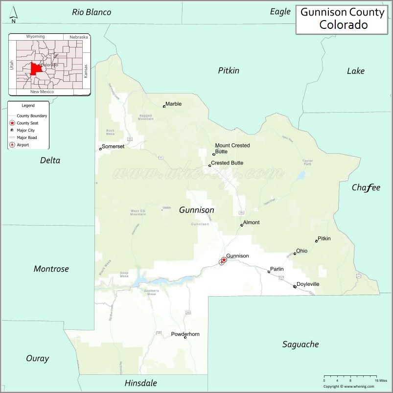
About Gunnison County Map, Colorado: The map showing the county boundary, county seat, major cities, highways, water bodies and neighbouring counties.
Most Viewed Links
Map of Gunnison County, Colorado
Gunnison County is a county located in the U.S. state of Colorado. It's county seat is Gunnison. As per 2020 census, the population of Gunnison County is 17281 people and population density is square miles. According to the United States Census Bureau, the county has a total area of 3,259.22 sq mi (8,441 km2). Gunnison County was established on -8331.
Gunnison County Facts
| Continent | North America |
| Country | United States |
| State | Colorado |
| County Seat | Gunnison |
| Largest City/Town | Gunnison |
| Established | 1877 |
| Total Area | 3,260 sq mi (8,443 sq km) |
| Land Area | 3,239 sq mi (8,389 sq km) |
| Water Area | 21 sq mi (54 sq km) |
| Population | 16,939 (Census 2020) |
| Population Density | 5.2 people per sq mi |
| Time Zone | Mountain Time Zone (MST/MDT) |
| Major Highways | US Highway 50, State Highway 135, State Highway 149 |
| Major Rivers | Gunnison River, Taylor River, East River |
| Neighboring Counties | Pitkin County, Chaffee County, Saguache County, Hinsdale County, Montrose County, Delta County, Mesa County |
| Famous For | Crested Butte skiing, Black Canyon region, mountain recreation, and alpine scenery |
| Top Attractions | Crested Butte, Blue Mesa Reservoir, Black Canyon nearby, Curecanti National Recreation Area |
| Official Website | Official Website |
About Gunnison County, Colorado
Gunnison County is located in central-western Colorado in the United States and was established in 1877. The county seat and largest town is Gunnison. The county is known for alpine mountain scenery, ski resorts, reservoirs, wilderness recreation, and extensive outdoor activities throughout the Rocky Mountains.
Cities and Towns in Gunnison County, Colorado
| City/Town | Population (Census 2020) | Latitude & Longitude |
|---|---|---|
| Gunnison (county seat) | 6,560 | 38.5458°N, 106.9253°W |
| Crested Butte | 1,639 | 38.8697°N, 106.9878°W |
| Marble | 133 | 39.0711°N, 107.1897°W |
| Mount Crested Butte | 801 | 38.8992°N, 106.9653°W |
| Pitkin | 72 | 38.6092°N, 106.5164°W |
| Parlin (CDP) | 40 | 38.5039°N, 106.7283°W |
| Almont (CDP) | 20 | 38.6664°N, 106.8492°W |
| Ohio City (historic community) | Historic site | 38.5950°N, 106.4328°W |
| Taylor Park communities | Regional area | 38.8200°N, 106.6100°W |
| Sapinero (CDP) | 90 | 38.4706°N, 107.3175°W |
Golf Courses in Gunnison County, Colorado
| Golf Course | Location | Latitude & Longitude |
|---|---|---|
| Dos Rios Golf Club | Gunnison | 38.5472°N, 106.9347°W |
| The Club at Crested Butte | Crested Butte | 38.8942°N, 106.9606°W |
| Skyland Golf Area | Crested Butte | 38.8564°N, 106.9697°W |
Roads and Highways in Gunnison County, Colorado
Major highways connect the county to mountain recreation areas, ski resorts, and neighboring valleys.
- US Highway 50 - major east-west route connecting Gunnison with Montrose, Salida, and western Colorado
- Colorado State Highway 135 - scenic route linking Gunnison with Crested Butte
- Colorado State Highway 149 - highway connecting Gunnison County with Lake City and the San Juan Mountains
Neighboring Counties of Gunnison County
- Pitkin County (north)
- Chaffee County (east)
- Saguache County (southeast)
- Hinsdale County (south)
- Montrose County (west)
- Delta County (west)
- Mesa County (northwest)
Top Attractions in Gunnison County, Colorado
The county offers a mix of natural and recreational attractions.
- Crested Butte Mountain Resort - major ski and mountain biking destination
- Blue Mesa Reservoir - Colorado's largest body of water popular for boating and fishing
- Curecanti National Recreation Area - scenic reservoir and canyon recreation region
- Black Canyon of the Gunnison National Park nearby - dramatic canyon landscapes and hiking trails
- Maroon Bells-Snowmass Wilderness access areas - alpine hiking and mountain scenery
- Taylor Park Reservoir - camping, fishing, ATV riding, and outdoor recreation area
- Gunnison National Forest - forest recreation area with hiking, camping, and wildlife viewing
- Crested Butte Wildflower Festival - annual event celebrating alpine wildflowers and mountain culture
- Monarch Pass nearby - scenic mountain pass with hiking and winter recreation
- Pioneer Museum in Gunnison - local history museum with mining and ranching exhibits
- Crystal Mill near Marble - famous historic mountain mill and photography destination
- Hartman Rocks Recreation Area - mountain biking and rock climbing area near Gunnison
Distance from Gunnison County to Nearby Cities
The following distances are measured by road (driving).
- Gunnison to Crested Butte (Gunnison County), Colorado - 28 mi (45 km)
- Gunnison to Montrose (Montrose County), Colorado - 65 mi (105 km)
- Gunnison to Salida (Chaffee County), Colorado - 64 mi (103 km)
- Gunnison to Aspen (Pitkin County), Colorado - 107 mi (172 km)
- Gunnison to Grand Junction (Mesa County), Colorado - 123 mi (198 km)
- Gunnison to Denver (Denver County), Colorado - 200 mi (322 km)
- Gunnison to Colorado Springs (El Paso County), Colorado - 163 mi (262 km)
- Gunnison to Durango (La Plata County), Colorado - 168 mi (270 km)
- Gunnison to Telluride (San Miguel County), Colorado - 129 mi (208 km)
- Gunnison to Breckenridge (Summit County), Colorado - 122 mi (196 km)
- Gunnison to Alamosa (Alamosa County), Colorado - 127 mi (204 km)
- Gunnison to Moab (Grand County), Utah - 233 mi (375 km)
FAQs about Gunnison County
Gunnison County is located in central-western Colorado within the Rocky Mountains region of the United States.
The population of Gunnison County was 16,939 according to the Census 2020.
Gunnison County is known for Crested Butte skiing, alpine scenery, reservoirs, and outdoor recreation opportunities.
The county is served by US Highway 50, Colorado State Highway 135, and Colorado State Highway 149.
Yes, Gunnison County has golf facilities including Dos Rios Golf Club and The Club at Crested Butte.
References
- QuickFacts - U.S. Census Bureau
- United States Census Bureau
- United States Geological Survey (USGS)
- National Geodetic Survey
- Official Website
- Adams County Map
- Alamosa County Map
- Arapahoe County Map
- Archuleta County Map
- Baca County Map
- Bent County Map
- Boulder County Map
- Broomfield County Map
- Chaffee County Map
- Cheyenne County Map
- Clear Creek County Map
- Conejos County Map
- Costilla County Map
- Crowley County Map
- Custer County Map
- Delta County Map
- Denver County Map
- Dolores County Map
- Douglas County Map
- Eagle County Map
- Elbert County Map
- El Paso County Map
- Fremont County Map
- Garfield County Map
- Gilpin County Map
- Grand County Map
- Gunnison County Map
- Hinsdale County Map
- Huerfano County Map
- Jackson County Map
- Jefferson County Map
- Kiowa County Map
- Kit Carson County Map
- Lake County Map
- La Plata County Map
- Larimer County Map
- Las Animas County Map
- Lincoln County Map
- Logan County Map
- Mesa County Map
- Mineral County Map
- Moffat County Map
- Montezuma County Map
- Montrose County Map
- Morgan County Map
- Otero County Map
- Ouray County Map
- Park County Map
- Phillips County Map
- Pitkin County Map
- Prowers County Map
- Pueblo County Map
- Rio Blanco County Map
- Rio Grande County Map
- Routt County Map
- Saguache County Map
- San Juan County Map
- San Miguel County Map
- Sedgwick County Map
- Summit County Map
- Teller County Map
- Washington County Map
- Weld County Map
- Yuma County Map
- Alabama Counties
- Alaska boroughs
- Arizona Counties
- Arkansas Counties
- California County Map
- Colorado Counties
- Connecticut Counties
- Delaware Counties
- Florida County Map
- Georgia County Map
- Hawaii Counties
- Idaho Counties
- Illinois Counties
- Indiana Counties
- Iowa Counties
- Kansas Counties
- Kentucky Counties
- Louisiana Counties
- Maine Counties
- Maryland Counties
- Massachusetts Counties
- Michigan County Map
- Minnesota Counties
- Mississippi Counties
- Missouri Counties
- Montana Counties
- Nebraska Counties
- Nevada Counties
- New York Counties
- New Hampshire Counties
- New Jersey Counties
- New Mexico Counties
- North Carolina Counties
- North Dakota Counties
- Ohio County Map
- Oklahoma Counties
- Oregon Counties
- Pennsylvania Counties
- Rhode Island Counties
- South Carolina Counties
- South Dakota Counties
- Map of Tennessee
- Texas County Map
- Utah Counties
- Vermont Counties
- Virginia Counties
- Washington Counties
- West Virginia Counties
- Wisconsin Counties
- Wyoming Counties