Map of Prowers County - Prowers County is a county located in the U.S. state of Colorado. Prowers County Map showing cities, highways, important places and water bodies. Get Where is Prowers County located in the map, major cities in Prowers county, population, areas, and places of interest.
Map of Prowers County, Colorado
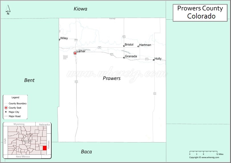
About Prowers County Map, Colorado: The map showing the county boundary, county seat, major cities, highways, water bodies and neighbouring counties.
Most Viewed Links
Map of Prowers County, Colorado
Prowers County is a county located in the U.S. state of Colorado. It's county seat is Lamar. As per 2020 census, the population of Prowers County is 11996 people and population density is square miles. According to the United States Census Bureau, the county has a total area of 1,645.37 sq mi (4,261 km2). Prowers County was established on -3915.
Prowers County Facts
| Continent | North America |
| Country | United States |
| State | Colorado |
| County Seat | Lamar |
| Largest City/Town | Lamar |
| Established | 1889 |
| Total Area | 1,644 sq mi (4,258 sq km) |
| Land Area | 1,638 sq mi (4,242 sq km) |
| Water Area | 6 sq mi (16 sq km) |
| Population | 11,999 (Census 2020) |
| Population Density | 7.3 people per sq mi |
| Time Zone | Mountain Time Zone (MST/MDT) |
| Major Highways | US Highway 50, US Highway 287, State Highway 196 |
| Major Rivers | Arkansas River |
| Neighboring Counties | Bent County, Kiowa County, Baca County, Hamilton County (KS), Stanton County (KS) |
| Famous For | Agriculture, Arkansas River valley, Lamar, and southeastern Colorado prairie landscapes |
| Top Attractions | Big Timbers Museum, Lamar Loop, John Martin Reservoir nearby, Sand Creek Massacre historic region |
| Official Website | Official Website |
About Prowers County, Colorado
Prowers County is located in southeastern Colorado in the United States and was established in 1889. The county seat and largest city is Lamar. The county is known for agriculture, prairie landscapes, historic Santa Fe Trail connections, and Arkansas River valley communities near the Kansas border.
Cities and Towns in Prowers County, Colorado
| City/Town | Population (Census 2020) | Latitude & Longitude |
|---|---|---|
| Lamar (county seat) | 7,687 | 38.0872°N, 102.6207°W |
| Granada | 505 | 38.0639°N, 102.3111°W |
| Holly | 802 | 38.0525°N, 102.1231°W |
| Hartman | 81 | 38.1214°N, 102.2194°W |
| Wiley | 405 | 38.1556°N, 102.7192°W |
| May Valley area | Rural prairie region | 38.1500°N, 102.4500°W |
| Big Timbers region | Historic Arkansas River area | 38.0833°N, 102.6333°W |
| Two Buttes nearby area | Regional landmark area | 37.5647°N, 102.3931°W |
Golf Courses in Prowers County, Colorado
| Golf Course | Location | Latitude & Longitude |
|---|---|---|
| Spreading Antlers Golf Course | Lamar | 38.0908°N, 102.6139°W |
| Springfield Golf Club | Springfield nearby | 37.4086°N, 102.6194°W |
| La Junta Municipal Golf Course | La Junta nearby | 37.9842°N, 103.5458°W |
Roads and Highways in Prowers County, Colorado
Major highways connect the county to southeastern Colorado, Kansas, and Arkansas River valley communities.
- US Highway 50 - major east-west highway connecting Lamar with Pueblo and western Kansas
- US Highway 287 - north-south route linking Lamar with Oklahoma, Texas, and northern Colorado
- Colorado State Highway 196 - regional highway serving agricultural and prairie communities
Neighboring Counties of Prowers County
- Bent County (west)
- Kiowa County (north)
- Baca County (south)
- Hamilton County, Kansas (east)
- Stanton County, Kansas (northeast)
Top Attractions in Prowers County, Colorado
The county offers a mix of prairie, historical, and cultural attractions.
- Big Timbers Museum - regional history museum focused on pioneer and Santa Fe Trail heritage
- Lamar Historic Downtown - local shops, restaurants, and historic architecture
- Arkansas River recreation areas - fishing, birdwatching, and outdoor activities
- Granada Relocation Center historical site nearby - preserved World War II Japanese American internment camp site
- John Martin Reservoir State Park nearby - boating, fishing, camping, and wildlife viewing destination
- Santa Fe Trail historic routes - wagon trail landmarks and interpretive areas
- Sand Creek Massacre National Historic Site region nearby - important historical landmark
- Prairie wildlife viewing areas - habitat for migratory birds and plains wildlife
- Spreading Antlers Golf Course - recreational golf destination in Lamar
- Local agricultural fairs and rodeos - events celebrating farming and ranching heritage
- High Plains scenic drives - open prairie landscapes and rural Colorado scenery
- Historic railroad heritage sites - transportation history tied to southeastern Colorado development
Distance from Prowers County to Nearby Cities
The following distances are measured by road (driving).
- Lamar to La Junta (Otero County), Colorado - 68 mi (109 km)
- Lamar to Pueblo (Pueblo County), Colorado - 128 mi (206 km)
- Lamar to Dodge City (Ford County), Kansas - 120 mi (193 km)
- Lamar to Colorado Springs (El Paso County), Colorado - 183 mi (294 km)
- Lamar to Denver (Denver County), Colorado - 242 mi (389 km)
- Lamar to Garden City (Finney County), Kansas - 96 mi (154 km)
- Lamar to Amarillo (Potter County), Texas - 220 mi (354 km)
- Lamar to Wichita (Sedgwick County), Kansas - 250 mi (402 km)
- Lamar to Albuquerque (Bernalillo County), New Mexico - 367 mi (591 km)
- Lamar to Grand Junction (Mesa County), Colorado - 415 mi (668 km)
- Lamar to Oklahoma City (Oklahoma County), Oklahoma - 351 mi (565 km)
- Lamar to Santa Fe (Santa Fe County), New Mexico - 283 mi (455 km)
FAQs about Prowers County
Prowers County is located in southeastern Colorado near the Kansas border in the United States.
The population of Prowers County was 11,999 according to the Census 2020.
Prowers County is known for agriculture, Arkansas River valley communities, prairie landscapes, and Santa Fe Trail history.
The county is served by US Highway 50, US Highway 287, and Colorado State Highway 196.
Popular attractions include the Big Timbers Museum, John Martin Reservoir nearby, Arkansas River recreation areas, and Santa Fe Trail historic sites.
References
- QuickFacts - U.S. Census Bureau
- United States Census Bureau
- United States Geological Survey (USGS)
- National Geodetic Survey
- Official Website
- Adams County Map
- Alamosa County Map
- Arapahoe County Map
- Archuleta County Map
- Baca County Map
- Bent County Map
- Boulder County Map
- Broomfield County Map
- Chaffee County Map
- Cheyenne County Map
- Clear Creek County Map
- Conejos County Map
- Costilla County Map
- Crowley County Map
- Custer County Map
- Delta County Map
- Denver County Map
- Dolores County Map
- Douglas County Map
- Eagle County Map
- Elbert County Map
- El Paso County Map
- Fremont County Map
- Garfield County Map
- Gilpin County Map
- Grand County Map
- Gunnison County Map
- Hinsdale County Map
- Huerfano County Map
- Jackson County Map
- Jefferson County Map
- Kiowa County Map
- Kit Carson County Map
- Lake County Map
- La Plata County Map
- Larimer County Map
- Las Animas County Map
- Lincoln County Map
- Logan County Map
- Mesa County Map
- Mineral County Map
- Moffat County Map
- Montezuma County Map
- Montrose County Map
- Morgan County Map
- Otero County Map
- Ouray County Map
- Park County Map
- Phillips County Map
- Pitkin County Map
- Prowers County Map
- Pueblo County Map
- Rio Blanco County Map
- Rio Grande County Map
- Routt County Map
- Saguache County Map
- San Juan County Map
- San Miguel County Map
- Sedgwick County Map
- Summit County Map
- Teller County Map
- Washington County Map
- Weld County Map
- Yuma County Map
- Alabama Counties
- Alaska boroughs
- Arizona Counties
- Arkansas Counties
- California County Map
- Colorado Counties
- Connecticut Counties
- Delaware Counties
- Florida County Map
- Georgia County Map
- Hawaii Counties
- Idaho Counties
- Illinois Counties
- Indiana Counties
- Iowa Counties
- Kansas Counties
- Kentucky Counties
- Louisiana Counties
- Maine Counties
- Maryland Counties
- Massachusetts Counties
- Michigan County Map
- Minnesota Counties
- Mississippi Counties
- Missouri Counties
- Montana Counties
- Nebraska Counties
- Nevada Counties
- New York Counties
- New Hampshire Counties
- New Jersey Counties
- New Mexico Counties
- North Carolina Counties
- North Dakota Counties
- Ohio County Map
- Oklahoma Counties
- Oregon Counties
- Pennsylvania Counties
- Rhode Island Counties
- South Carolina Counties
- South Dakota Counties
- Map of Tennessee
- Texas County Map
- Utah Counties
- Vermont Counties
- Virginia Counties
- Washington Counties
- West Virginia Counties
- Wisconsin Counties
- Wyoming Counties