Map of Crowley County - Crowley County is a county located in the U.S. state of Colorado. Crowley County Map showing cities, highways, important places and water bodies. Get Where is Crowley County located in the map, major cities in Crowley county, population, areas, and places of interest.
Map of Crowley County, Colorado
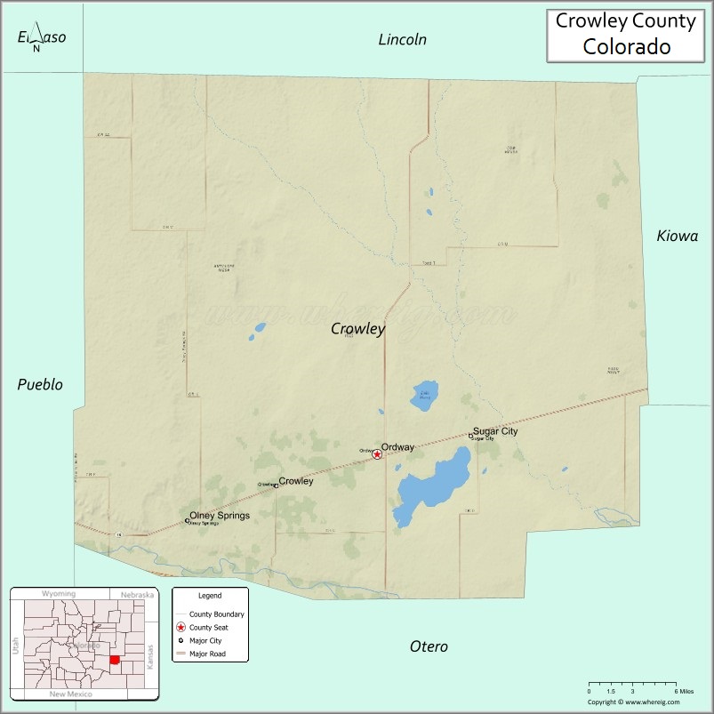
About Crowley County Map, Colorado: The map showing the county boundary, county seat, major cities, highways, water bodies and neighbouring counties.
Most Viewed Links
Map of Crowley County, Colorado
Crowley County is a county located in the U.S. state of Colorado. It's county seat is Ordway. As per 2020 census, the population of Crowley County is 6012 people and population density is square miles. According to the United States Census Bureau, the county has a total area of 800.27 sq mi (2,073 km2). Crowley County was established on 4167.
Crowley County Facts
| Continent | North America |
| Country | United States |
| State | Colorado |
| County Seat | Ordway |
| Largest City/Town | Ordway |
| Established | 1911 |
| Total Area | 800 sq mi (2,072 sq km) |
| Land Area | 787 sq mi (2,039 sq km) |
| Water Area | 13 sq mi (34 sq km) |
| Population | 5,922 (Census 2020) |
| Population Density | 7.5 people per sq mi |
| Time Zone | Mountain Time Zone (MST/MDT) |
| Major Highways | US Highway 50, State Highway 96, State Highway 71 |
| Major Rivers | Arkansas River |
| Neighboring Counties | Lincoln County, Otero County, Pueblo County, Kiowa County |
| Famous For | Agriculture, Arkansas Valley farming, historic rail communities, and prairie landscapes |
| Top Attractions | Lake Henry, Arkansas River Valley, Crowley County Heritage Center, Ordway parks |
| Official Website | Official Website |
About Crowley County, Colorado
Crowley County is located in southeastern Colorado in the United States and was established in 1911. The county seat and largest town is Ordway. The county lies within the Arkansas River Valley region and is known for farming, ranching, prairie scenery, irrigation agriculture, and small rural communities.
Cities and Towns in Crowley County, Colorado
| City/Town | Population (Census 2020) | Latitude & Longitude |
|---|---|---|
| Ordway (county seat) | 1,066 | 38.2181°N, 103.7564°W |
| Crowley | 166 | 38.1931°N, 103.8578°W |
| Olney Springs | 315 | 38.1639°N, 103.9431°W |
| Sugar City | 237 | 38.2361°N, 103.6631°W |
| North Avondale (CDP) | 210 | 38.2439°N, 103.6575°W |
Golf Courses in Crowley County, Colorado
| Golf Course | Location | Latitude & Longitude |
|---|---|---|
| Ordway Golf Club | Ordway | 38.2206°N, 103.7478°W |
| Arkansas Valley Regional Golf Area | Sugar City | 38.2375°N, 103.6642°W |
Roads and Highways in Crowley County, Colorado
Major highways connect the county to southeastern Colorado communities and agricultural regions.
- US Highway 50 - major east-west route connecting Ordway with Pueblo and La Junta
- Colorado State Highway 96 - regional highway linking the county with Kiowa County and Pueblo County
- Colorado State Highway 71 - north-south route connecting Ordway with Rocky Ford and eastern plains areas
Neighboring Counties of Crowley County
- Lincoln County (north)
- Kiowa County (east)
- Otero County (south)
- Pueblo County (west)
Top Attractions in Crowley County, Colorado
The county offers a mix of natural and historical attractions.
- Lake Henry - reservoir area popular for fishing, boating, and birdwatching
- Arkansas River Valley Landscapes - scenic agricultural valley with open prairie views
- Crowley County Heritage Center - museum highlighting local farming and railroad history
- Ordway City Park - public park with recreation facilities and community events
- Olney Springs Community Area - small-town historic district and recreation spaces
- Great Plains Prairie Areas - open grasslands with wildlife viewing opportunities
- Sugar City Historic Community - historic agricultural settlement in the Arkansas Valley
- Lake Meredith nearby - regional recreation area for camping and fishing
- Crowley County Fairgrounds - local venue for rodeos, fairs, and agricultural events
- Historic Railroad Corridors - former rail routes tied to early southeastern Colorado development
Distance from Crowley County to Nearby Cities
The following distances are measured by road (driving).
- Ordway to La Junta (Otero County), Colorado - 22 mi (35 km)
- Ordway to Pueblo (Pueblo County), Colorado - 58 mi (93 km)
- Ordway to Rocky Ford (Otero County), Colorado - 18 mi (29 km)
- Ordway to Colorado Springs (El Paso County), Colorado - 98 mi (158 km)
- Ordway to Lamar (Prowers County), Colorado - 81 mi (130 km)
- Ordway to Denver (Denver County), Colorado - 170 mi (274 km)
- Ordway to Canon City (Fremont County), Colorado - 81 mi (130 km)
- Ordway to Trinidad (Las Animas County), Colorado - 116 mi (187 km)
- Ordway to Walsenburg (Huerfano County), Colorado - 89 mi (143 km)
- Ordway to Burlington (Kit Carson County), Colorado - 153 mi (246 km)
- Ordway to Garden City (Finney County), Kansas - 211 mi (340 km)
- Ordway to Dodge City (Ford County), Kansas - 189 mi (304 km)
FAQs about Crowley County
Crowley County is located in southeastern Colorado within the Arkansas River Valley region of the United States.
The population of Crowley County was 5,922 according to the Census 2020.
Crowley County is known for agriculture, prairie landscapes, Arkansas Valley farming, and rural Colorado communities.
The county is served by US Highway 50, Colorado State Highway 96, and Colorado State Highway 71.
Yes, Crowley County has local golf facilities including Ordway Golf Club and nearby regional golf areas.
References
- QuickFacts - U.S. Census Bureau
- United States Census Bureau
- United States Geological Survey (USGS)
- National Geodetic Survey
- Official Website
- Adams County Map
- Alamosa County Map
- Arapahoe County Map
- Archuleta County Map
- Baca County Map
- Bent County Map
- Boulder County Map
- Broomfield County Map
- Chaffee County Map
- Cheyenne County Map
- Clear Creek County Map
- Conejos County Map
- Costilla County Map
- Crowley County Map
- Custer County Map
- Delta County Map
- Denver County Map
- Dolores County Map
- Douglas County Map
- Eagle County Map
- Elbert County Map
- El Paso County Map
- Fremont County Map
- Garfield County Map
- Gilpin County Map
- Grand County Map
- Gunnison County Map
- Hinsdale County Map
- Huerfano County Map
- Jackson County Map
- Jefferson County Map
- Kiowa County Map
- Kit Carson County Map
- Lake County Map
- La Plata County Map
- Larimer County Map
- Las Animas County Map
- Lincoln County Map
- Logan County Map
- Mesa County Map
- Mineral County Map
- Moffat County Map
- Montezuma County Map
- Montrose County Map
- Morgan County Map
- Otero County Map
- Ouray County Map
- Park County Map
- Phillips County Map
- Pitkin County Map
- Prowers County Map
- Pueblo County Map
- Rio Blanco County Map
- Rio Grande County Map
- Routt County Map
- Saguache County Map
- San Juan County Map
- San Miguel County Map
- Sedgwick County Map
- Summit County Map
- Teller County Map
- Washington County Map
- Weld County Map
- Yuma County Map
- Alabama Counties
- Alaska boroughs
- Arizona Counties
- Arkansas Counties
- California County Map
- Colorado Counties
- Connecticut Counties
- Delaware Counties
- Florida County Map
- Georgia County Map
- Hawaii Counties
- Idaho Counties
- Illinois Counties
- Indiana Counties
- Iowa Counties
- Kansas Counties
- Kentucky Counties
- Louisiana Counties
- Maine Counties
- Maryland Counties
- Massachusetts Counties
- Michigan County Map
- Minnesota Counties
- Mississippi Counties
- Missouri Counties
- Montana Counties
- Nebraska Counties
- Nevada Counties
- New York Counties
- New Hampshire Counties
- New Jersey Counties
- New Mexico Counties
- North Carolina Counties
- North Dakota Counties
- Ohio County Map
- Oklahoma Counties
- Oregon Counties
- Pennsylvania Counties
- Rhode Island Counties
- South Carolina Counties
- South Dakota Counties
- Map of Tennessee
- Texas County Map
- Utah Counties
- Vermont Counties
- Virginia Counties
- Washington Counties
- West Virginia Counties
- Wisconsin Counties
- Wyoming Counties